Report on Sangay (Ecuador) — January 2019

Bulletin of the Global Volcanism Network, vol. 44, no. 1 (January 2019)
Managing Editor: Edward Venzke.
Edited by Janine B. Krippner.
Sangay (Ecuador) Eruption produced ash plumes, lava flows, and rockfalls during August-December 2018
Please cite this report as:
Global Volcanism Program, 2019. Report on Sangay (Ecuador) (Krippner, J.B., and Venzke, E., eds.). Bulletin of the Global Volcanism Network, 44:1. Smithsonian Institution. https://doi.org/10.5479/si.GVP.BGVN201901-352090
Sangay
Ecuador
2.005°S, 78.341°W; summit elev. 5286 m
All times are local (unless otherwise noted)
Sangay is the southernmost active volcano in Ecuador and has displayed frequent eruptive activity since 1628, producing pyroclastic flows, lava flows, ash plumes, and lahars. An eruption from July through October 2017 produced ash plumes and lava flows on the ESE flank. After nine months of quiescence an eruption occurred from 8 August to 7 December 2018, with four months of continuous activity producing ash plumes, lava flows, and rockfalls. This report covers March through December 2018 and summarizes reports issued by the Instituto Geofisico, the Washington Volcano Ash Advisory Center (VAAC), and satellite data.
There was no reported activity from March through July. After nine months of inactivity a new eruptive phase began on 8 August 2018. On this day the Washington VAAC reported a possible ash plume that rose approximately 500 m above the vent and drifted 28 km WSW. An ash plume on 11 August reached a height of 2.3 km above the crater and moved towards the WSW. Prior to these two events, the last ash plume was detected on 13 October 2017.
The NASA Fire Information for Resource Management System (FIRMS) thermal alert and the first thermal anomaly alert issued by the MODVOLC near-real-time thermal monitoring algorithm for this eruptive episode was on 14 August. The eruption onset was confirmed visually on 14 August when an incandescent lava flow was seen on the upper SE flank on a webcam image (figure 25). Sentinel-2 detected elevated temperatures at the summit and lava effusion on the ESE flank (figure 26).
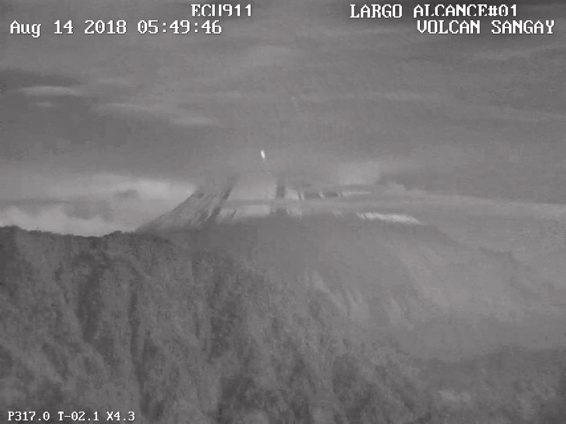 |
Figure 25. Visual confirmation of eruptive activity with incandescence on the upper SE flank of Sangay volcano on 14 August. Webcam image by ECU911 from the city of Macas, courtesy of Instituto Geofisico (14 August 2018 report). |
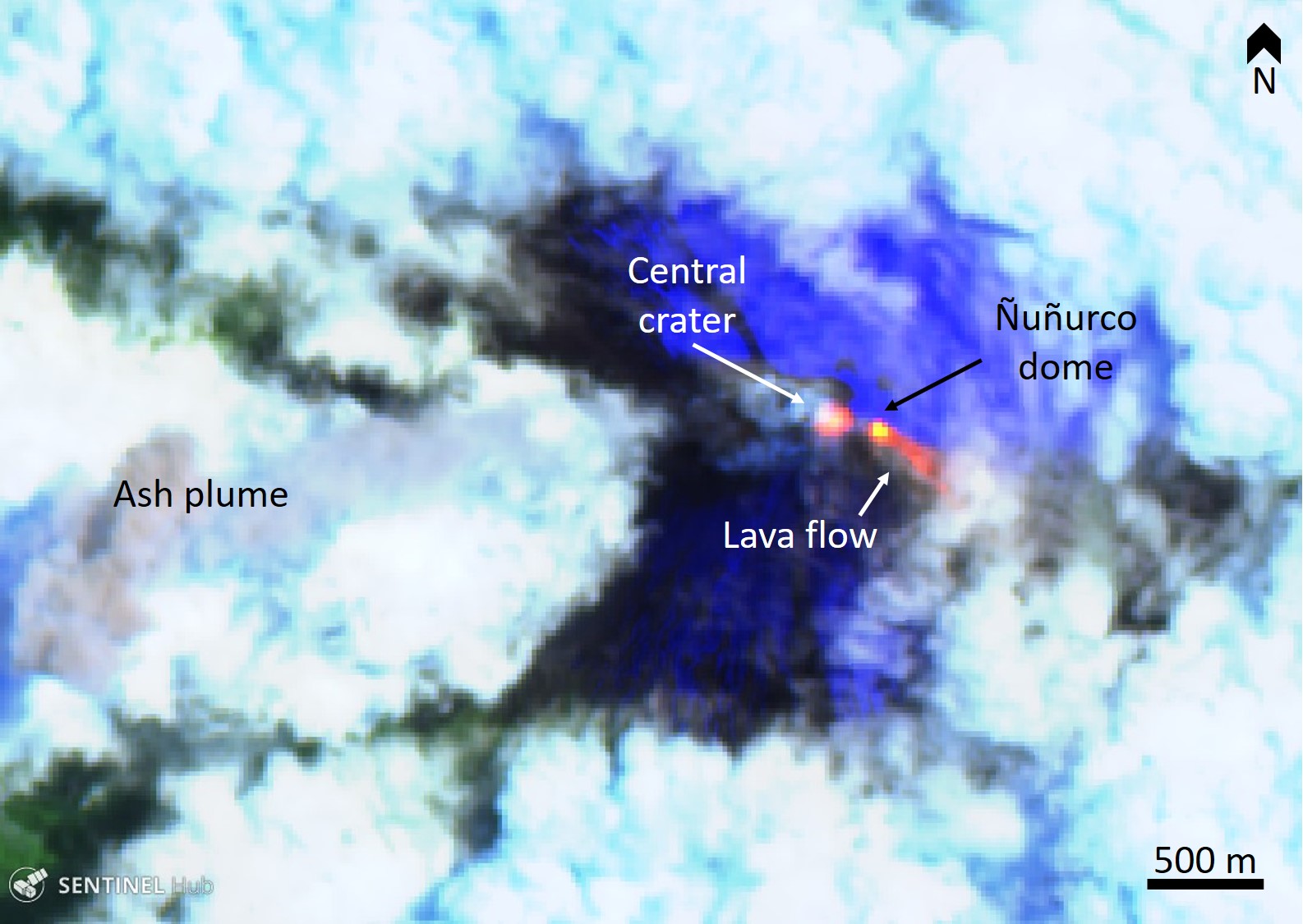 |
Figure 26. Sentinel-2 thermal satellite image showing the active central crater, Ñuñurco dome, and a lava flow (bright orange/yellow) on the ESE flank of Sangay on 25 August 2018. The bright blue indicates snow on the volcano and the white/light blue areas are meteoric clouds. Sentinel-2 false color (Urban) image (bands 12, 11, 4) courtesy of Sentinel Hub Playground. |
During 28 August to 3 September ash emissions reached altitudes of 5.8-6.7 km and traveled various directions out to 45 km. Ash plumes on 11, 13, 15, and 17 September reached altitudes of 5.8-6.4 km and drifted to the SW and W. Light ashfall occurred in the city of Guayaquil on 18 September, 170 km W. Ash plumes reached 5.8 to 6.1 km altitude on 19 and 20 September and drifted 37 km to the WNW and W.
Activity continued through October with lava emission. A Sentinel-2 thermal satellite image acquired on 24 October shows the lava flow on the ESE flank, with elevated thermal energy at the central crater and the Ñuñurco dome (figure 27). The final MODVOLC thermal alert was on 30 November 2018. During this time, lava flows were emitted and flowed down the ESE flank, and ash plumes were often produced and traveled to the W and NW (figure 28). From 2 December there was a substantial decrease in seismicity, ten times less than the previous months (figure 29). No further activity was noted in December.
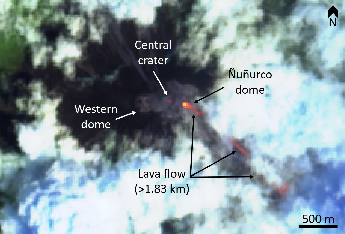 |
Figure 27. False color Sentinel-2 Satellite image of Sangay acquired on 24 October 2018 showing the active crater, the Ñuñurco dome, and a hot lava flow (bright orange/yellow) that has traveled more than 1.83 km. Sentinel-2 false color (Urban) image (bands 12, 11, 4) courtesy of Sentinel Hub Playground, figure labels and description courtesy of Instituto Geofisico (17 December 2018 report). |
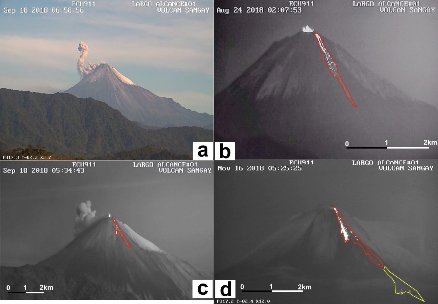 |
Figure 28. The activity of Sangay during September, August, and November 2018. Small explosive events occurred at the main crater throughout the eruptive episode. The red outlines the active lava flow on the ESE flank and the yellow indicates the area impacted by rockfalls and possible collapse of the lava flow front. Annotated images courtesy of Instituto Geofisico (21 November 2018 report), webcam images taken by ECU-911 from the city of Macas. |
 |
Figure 29. Chart showing the number of seismic events during the November-December 2018 activity at Sangay. The tremor was related to the lava flow activity, VT (volcano-tectonic) events are related to rock fracturing, LP (long-period) events are related to fluid movement, and explosions are the number of detected explosions. Between 25 and 88 explosions were detected per day prior to a decrease in seismicity on 2 December. Courtesy of Instituto Geofisico (17 December 2018 report). |
Elevated temperatures on the volcano were detected from 14 August to 30 November (figure 30). During this period the Washington Volcanic Ash Advisory Center (VAAC) issued 164 alerts for ash plumes. The ash plumes occasionally exceeded 2 km above the crater but were typically below 1.4 km, drifting in different directions through time (figures 31 and 32). The continuous emission of lava produced flows that traveled 1-2 km from the vent. Rockfalls and possible small pyroclastic flows produced at the lava flow fronts reached a distance of 7 km from the crater. Due to a decrease in thermal activity, ash plumes, and seismicity, Instituto Geofisico declared the eruption over on 7 December, after 121 days of activity.
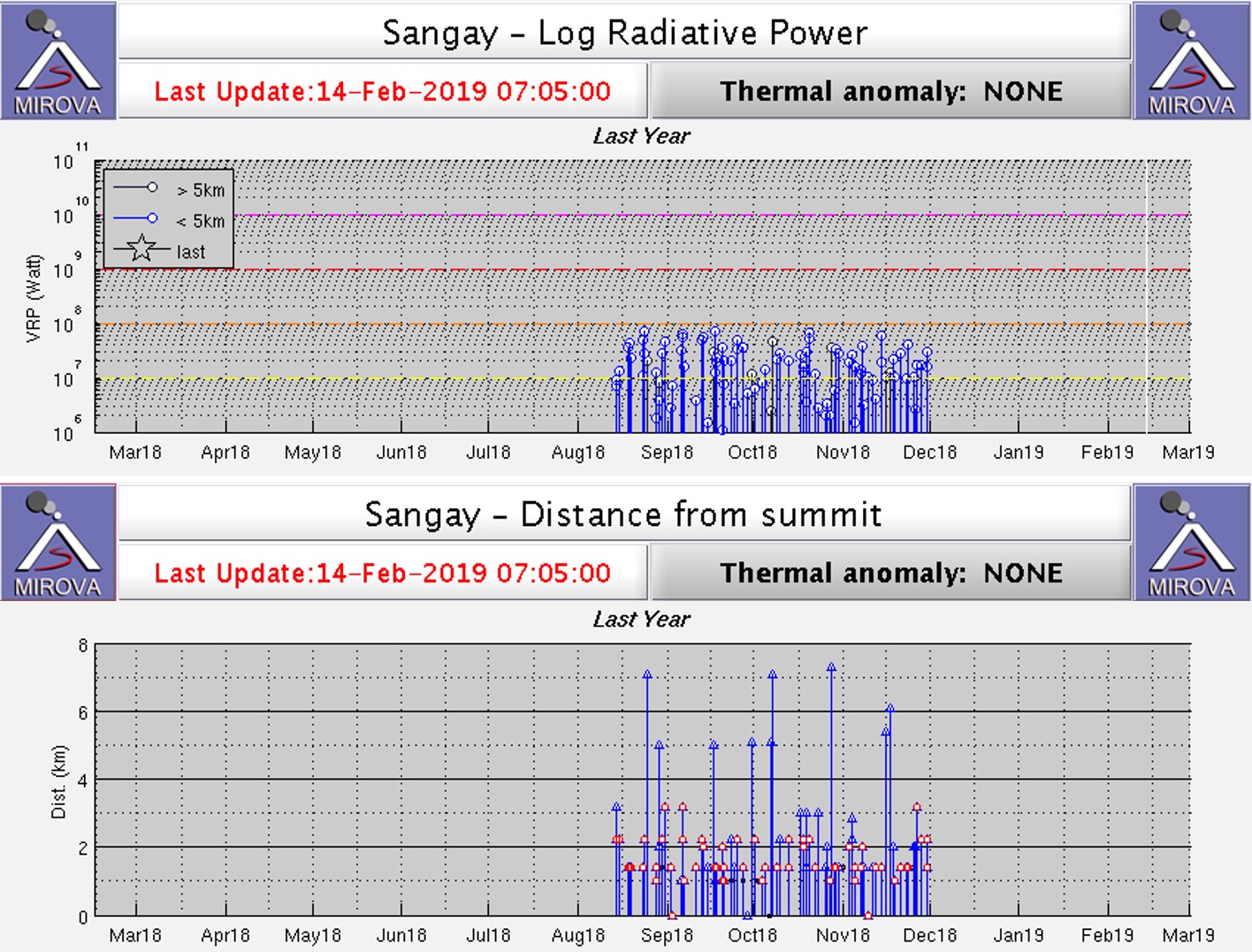 |
Figure 30. Plot of MODIS (Moderate Resolution Imaging Spectroradiometer) thermal infrared satellite data analyzed by MIROVA from February 2018 to 2019. Top: the log radiative power of thermal anomalies showing through the eruptive episode. Bottom: The locations of the crater, dome, and lava flow as indicated by thermal anomalies, measured as the distance of the thermal anomalies from the vent in kilometers. Courtesy of MIROVA. |
 |
Figure 31. The ash plume heights in meters above the Sangay crater during the 2018 August to December eruption period (top) with detected thermal energy (bottom). Ash plume heights were given by the Washington VAAC and thermal anomalies were calculated by the MODVOLC satellite algorithm. Courtesy of Instituto Geofisico (17 December 2018 report). |
 |
Figure 32. A summary of ash plumes from Sangay during the August-December 2018 eruptive episode. A) The ash plume heights as reported by the Washington VAAC. The red line gives the average value for that month while the box represents the standard deviation. The maximum heights are indicated by the circles. B) The ash plume extents overlain over an image of Ecuador. Courtesy of Instituto Geofisico (21 November 2018 report). |
Geological Summary. The isolated Sangay volcano, located east of the Andean crest, is the southernmost of Ecuador's volcanoes and its most active. The steep-sided, glacier-covered, dominantly andesitic volcano grew within the open calderas of two previous edifices which were destroyed by collapse to the east, producing large debris avalanches that reached the Amazonian lowlands. The modern edifice dates back to at least 14,000 years ago. It towers above the tropical jungle on the east side; on the other sides flat plains of ash have been eroded by heavy rains into steep-walled canyons up to 600 m deep. The earliest report of an eruption was in 1628. Almost continuous eruptions were reported from 1728 until 1916, and again from 1934 to the present. The almost constant activity has caused frequent changes to the morphology of the summit crater complex.
Information Contacts: Instituto Geofísico (IG-EPN), Escuela Politécnica Nacional, Casilla 17-01-2759, Quito, Ecuador (URL: http://www.igepn.edu.ec); ECU911 - Integrated Security Service ECU 911, ulio Endara street s/n. Sector Parque Itchimbía Quito – Ecuador (URL: http://www.ecu911.gob.ec/servicio-integrado-de-seguridad-ecu-911/); Hawai'i Institute of Geophysics and Planetology (HIGP) - MODVOLC Thermal Alerts System, School of Ocean and Earth Science and Technology (SOEST), Univ. of Hawai'i, 2525 Correa Road, Honolulu, HI 96822, USA (URL: http://modis.higp.hawaii.edu/); MIROVA (Middle InfraRed Observation of Volcanic Activity), a collaborative project between the Universities of Turin and Florence (Italy) supported by the Centre for Volcanic Risk of the Italian Civil Protection Department (URL: http://www.mirovaweb.it/); Sentinel Hub Playground (URL: https://www.sentinel-hub.com/explore/sentinel-playground).