Report on Kerinci (Indonesia) — February 2019
Bulletin of the Global Volcanism Network, vol. 44, no. 2 (February 2019)
Managing Editor: Edward Venzke.
Edited by Janine B. Krippner.
Kerinci (Indonesia) A persistent gas-and-steam plume and intermittent ash plumes occurred from July 2018 through January 2019
Please cite this report as:
Global Volcanism Program, 2019. Report on Kerinci (Indonesia) (Krippner, J.B., and Venzke, E., eds.). Bulletin of the Global Volcanism Network, 44:2. Smithsonian Institution. https://doi.org/10.5479/si.GVP.BGVN201902-261170
Kerinci
Indonesia
1.697°S, 101.264°E; summit elev. 3800 m
All times are local (unless otherwise noted)
Kerinci is a frequently active volcano in Sumatra, Indonesia. Recent activity has consisted of intermittent explosions, ash, and gas-and-steam plumes. The volcano alert has been at Level II since 9 September 2007. This report summarizes activity during July 2018-January 2019 based on reports by The Indonesia volcano monitoring agency, Pusat Vulkanologi dan Mitigasi Bencana Geologi (PVMBG, also known as Indonesian Center for Volcanology and Geological Hazard Mitigation, CVGHM), MAGMA Indonesia, notices from the Darwin Volcano Ash Advisory Center (Darwin VAAC), and satellite data.
Throughout this period dilute gas-and-steam plumes rising about 300 m above the summit were frequently observed and seismicity continued (figure 6). During July through January ash plumes were observed by the Darwin VAAC up to 4.3 km altitude and dispersed in multiple directions (table 7 and figure 7).
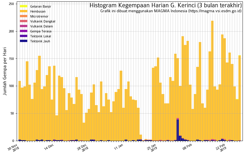 |
Figure 6. Graph showing seismic activity at Kerinci from November 2018 through February 2019. Courtesy of MAGMA Indonesia. |
Table 7. Summary of ash plumes (altitude and drift direction) for Kerinci during July 2018 through January 2019. The summit is at 3.5 km altitude. Data courtesy of the Darwin Volcanic Ash Advisory Center (VAAC) and MAGMA Indonesia.
| Date | Ash plume altitude (km) | Ash plume drift direction |
| 22 Jul 2018 | 4.3 | SW |
| 28-30 Sep 2018 | 4.3 | SW, W |
| 02 Oct 2018 | 4.3 | SW, W |
| 18-22 Oct 2018 | 4.3 | N, W, WSW, SW |
| 19 Jan 2019 | 4 | E to SE |
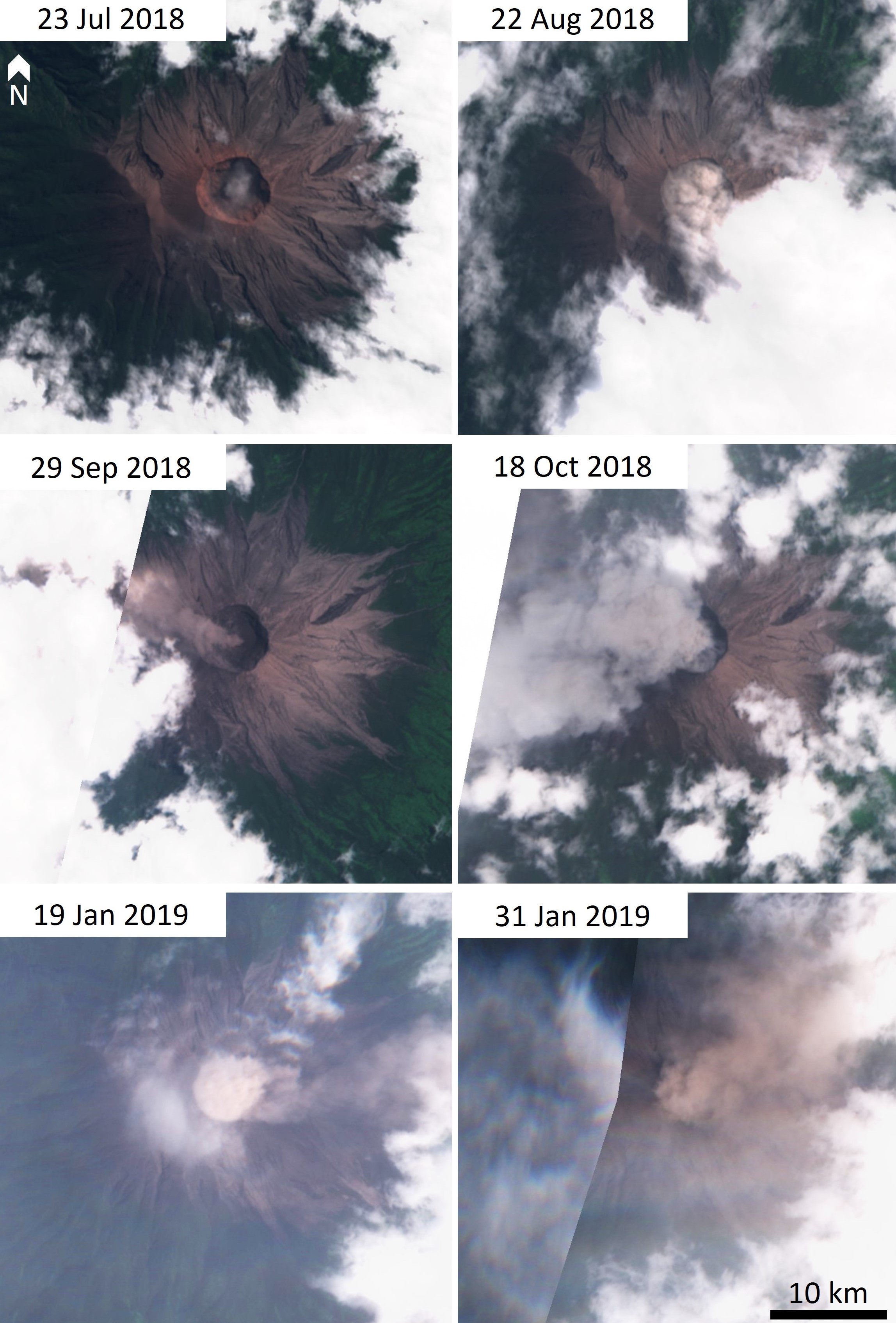 |
Figure 7. Dilute ash plumes at Kerinci during July 2018-January 2019. Sentinel-2 natural color (bands 4, 3, 2) satellite images courtesy of Sentinel Hub Playground. |
Based on satellite data, a Darwin VAAC advisory reported an ash plume to 4.3 km altitude on 22 July that drifted to the SW and S. Only one day with elevated thermal emission was noted in Sentinel-2 satellite data for the entire reporting period, on 13 September 2018 (figure 8). No thermal signatures were detected by MODVOLC. On 28-29 September there was an ash plume observed to 500-600 m above the peak that dispersed to the W. Several VAAC reports on 2 and 18-22 October detected ash plumes that rose to 4.3 km altitude and drifted in different directions. On 19 January from 0734 to 1000 an ash plume rose to 200 m above the crater and dispersed to the E and SE (figure 9).
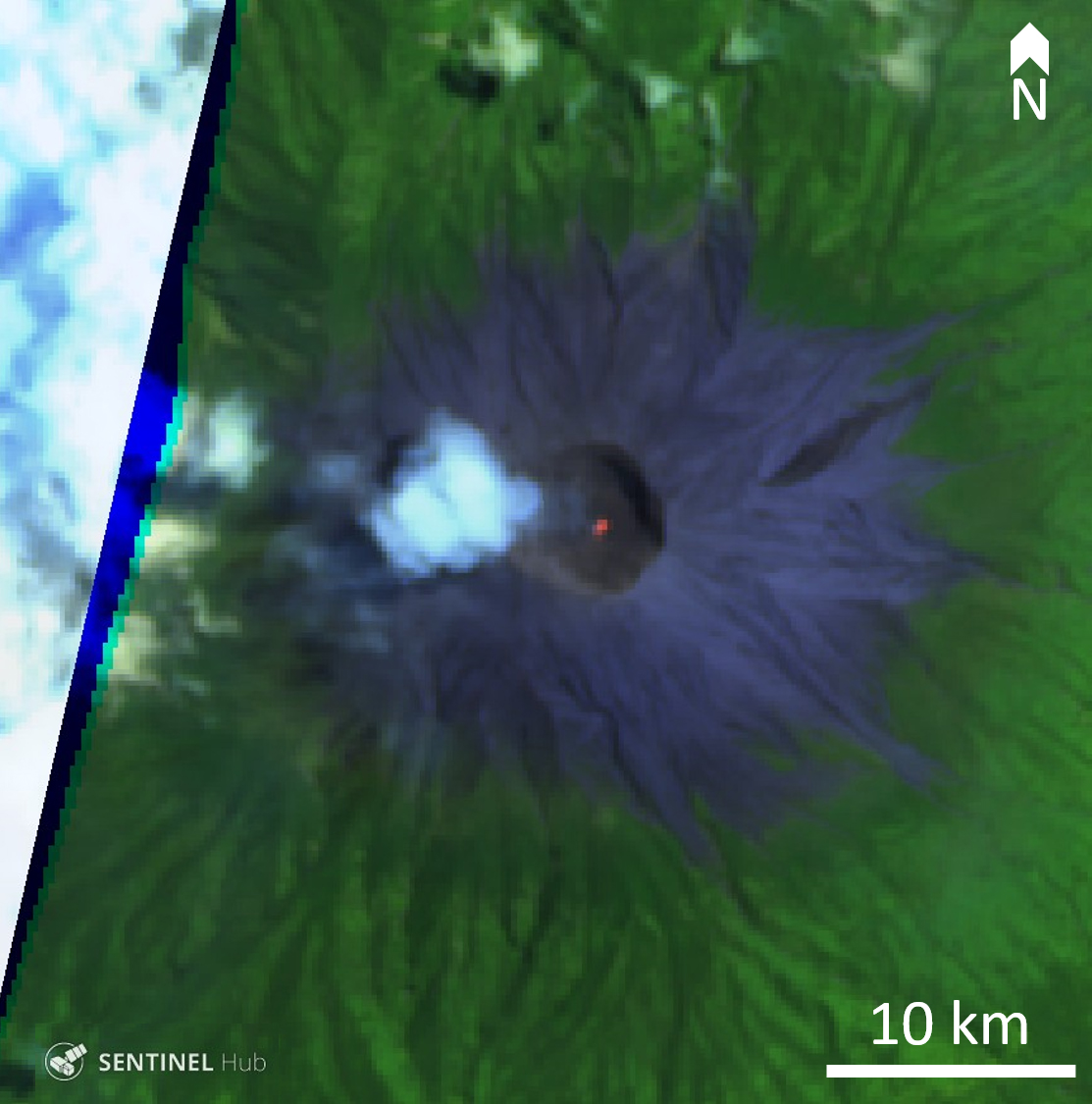 |
Figure 8. Small thermal anomaly at Kerinci volcano on 13 September 2018. False color (urban) image (band 12, 11, 4) courtesy of Sentinel Hub Playground. |
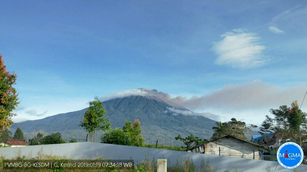 |
Figure 9. Small ash plume at Kerinci on 19 January 2019 that reached 200 m above the crater and traveled west. Courtesy of MAGMA Indonesia. |
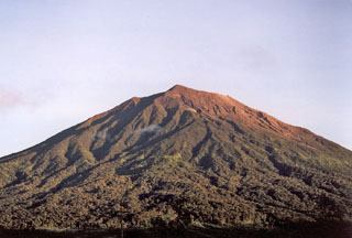
Geological Summary. Gunung Kerinci in central Sumatra forms Indonesia's highest volcano and is one of the most active in Sumatra. It is capped by an unvegetated young summit cone that was constructed NE of an older crater remnant. There is a deep 600-m-wide summit crater often partially filled by a small crater lake that lies on the NE crater floor, opposite the SW-rim summit. The massive 13 x 25 km wide volcano towers 2400-3300 m above surrounding plains and is elongated in a N-S direction. Frequently active, Kerinci has been the source of numerous moderate explosive eruptions since its first recorded eruption in 1838.
Information Contacts: Pusat Vulkanologi dan Mitigasi Bencana Geologi (PVMBG, also known as Indonesian Center for Volcanology and Geological Hazard Mitigation, CVGHM), Jalan Diponegoro 57, Bandung 40122, Indonesia (URL: http://www.vsi.esdm.go.id/); MAGMA Indonesia, Kementerian Energi dan Sumber Daya Mineral (URL: https://magma.vsi.esdm.go.id/); Darwin Volcanic Ash Advisory Centre (VAAC), Bureau of Meteorology, Northern Territory Regional Office, PO Box 40050, Casuarina, NT 0811, Australia (URL: http://www.bom.gov.au/info/vaac/); Sentinel Hub Playground (URL: https://www.sentinel-hub.com/explore/sentinel-playground).