Report on Bezymianny (Russia) — February 2019
Bulletin of the Global Volcanism Network, vol. 44, no. 2 (February 2019)
Managing Editor: Edward Venzke.
Research and preparation by Sara Arav-Piper.
Bezymianny (Russia) Ongoing low-level thermal anomalies during July 2018-January 2019; some strong ash explosions
Please cite this report as:
Global Volcanism Program, 2019. Report on Bezymianny (Russia) (Venzke, E., ed.). Bulletin of the Global Volcanism Network, 44:2. Smithsonian Institution. https://doi.org/10.5479/si.GVP.BGVN201902-300250
Bezymianny
Russia
55.972°N, 160.595°E; summit elev. 2882 m
All times are local (unless otherwise noted)
Volcanic activity at Bezymianny has been frequent for the past 60 years, and almost continuous since May 2010. Moderate gas-steam activity and thermal anomalies were reported during the majority of this reporting period from July 2018 through January 2019 with one explosive event reported in 20 January 2019 (figure 28). Weekly data for this reporting period was provided by the Kamchatka Volcanic Eruptions Response Team (KVERT), during which the Aviation Color Code (ACC) remained at Yellow (the second lowest level in a four color alert code).
Moderate gas-and-steam activity was reported during this period from the beginning of July 2018 (figure 27) through 20 January 2019, although cloud cover frequently obscured views. On 20 July 2018, KVERT reported that satellite data showed an ash cloud that drifted for about 100 km SE. Another strong explosive eruption at 1610 UTC on 20 January 2019 resulted in an ash plume that rose to 10-11 km and drifted for about 870 km NW (figure 28).
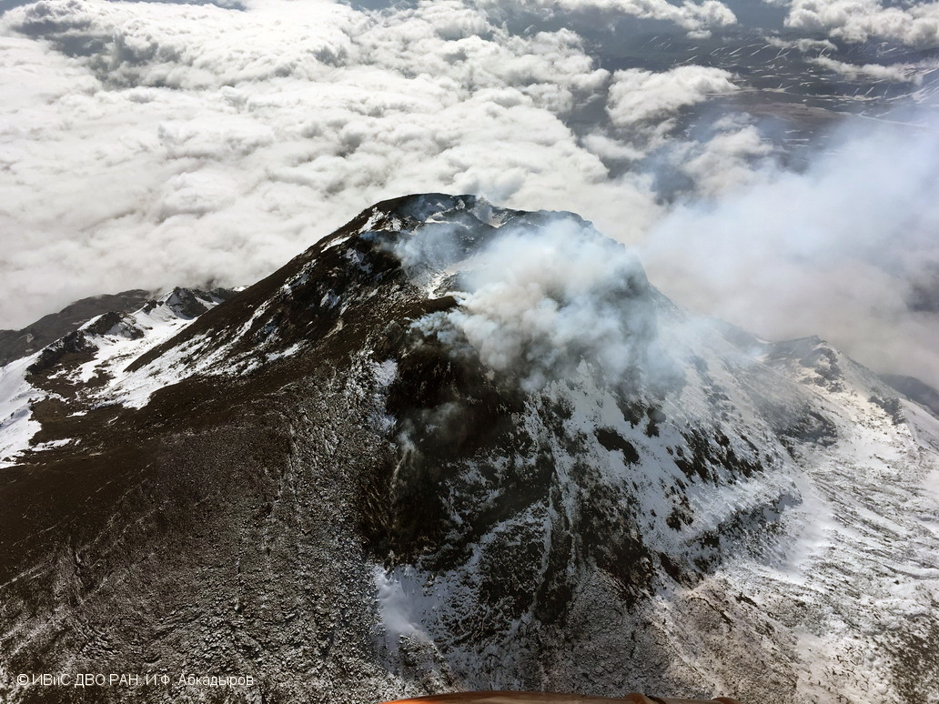 |
Figure 27. Aerial photo showing the lava dome at Bezymianny on 9 July 2018. Photo by I. F. Abkadryov, courtesy of Institute of Volcanology and Seismoloty FEB, IVS FEB RAS, KVERT. |
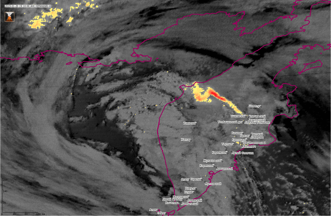 |
Figure 28. Himawari-8 satellite image showing the ash plume from an explosive eruption at Bezymianny extending W across the Kamchatka Peninsula at 1910 UTC on 20 January 2019. Data from VolSatView information system; courtesy of Institute of Volcanology and Seismology IVS FEB RAS, KVERT. |
A thermal anomaly at the volcano was reported by KVERT throughout this period. MODIS infrared satellite data processed by MIROVA showed low-power thermal anomalies over the previous year, with an increase in frequency and power during 22-27 January 2019 (figure 29).
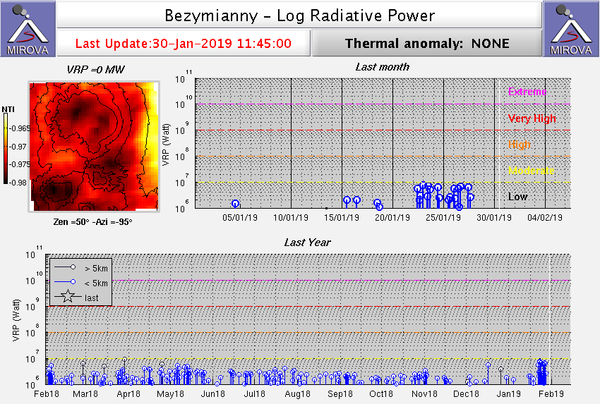 |
Figure 29. Thermal anomalies at Beymianny for the year ending 30 January 2019 recorded by the MIROVA system (log radiative power). Courtesy of MIROVA. |
Geological Summary. The modern Bezymianny, much smaller than its massive neighbors Kamen and Kliuchevskoi on the Kamchatka Peninsula, was formed about 4,700 years ago over a late-Pleistocene lava-dome complex and an edifice built about 11,000-7,000 years ago. Three periods of intensified activity have occurred during the past 3,000 years. The latest period, which was preceded by a 1,000-year quiescence, began with the dramatic 1955-56 eruption. This eruption, similar to that of St. Helens in 1980, produced a large open crater that was formed by collapse of the summit and an associated lateral blast. Subsequent episodic but ongoing lava-dome growth, accompanied by intermittent explosive activity and pyroclastic flows, has largely filled the 1956 crater.
Information Contacts: Kamchatka Volcanic Eruptions Response Team (KVERT), Far Eastern Branch, Russian Academy of Sciences, 9 Piip Blvd., Petropavlovsk-Kamchatsky, 683006, Russia (URL: http://www.kscnet.ru/ivs/kvert/); Institute of Volcanology and Seismology, Far Eastern Branch, Russian Academy of Sciences (IVS FEB RAS), 9 Piip Blvd., Petropavlovsk-Kamchatsky 683006, Russia (URL: http://www.kscnet.ru/ivs/eng/); MIROVA (Middle InfraRed Observation of Volcanic Activity), a collaborative project between the Universities of Turin and Florence (Italy) supported by the Centre for Volcanic Risk of the Italian Civil Protection Department (URL: http://www.mirovaweb.it/).