Report on Semeru (Indonesia) — April 2019

Bulletin of the Global Volcanism Network, vol. 44, no. 4 (April 2019)
Managing Editor: Edward Venzke.
Research and preparation by Paul Berger.
Semeru (Indonesia) Decreased activity after October 2018
Please cite this report as:
Global Volcanism Program, 2019. Report on Semeru (Indonesia) (Venzke, E., ed.). Bulletin of the Global Volcanism Network, 44:4. Smithsonian Institution. https://doi.org/10.5479/si.GVP.BGVN201904-263300
Semeru
Indonesia
8.108°S, 112.922°E; summit elev. 3657 m
All times are local (unless otherwise noted)
The ongoing eruption at Semeru has been characterized by numerous ash explosions and thermal anomalies, but activity apparently diminished in 2018 (BGVN 43:01 and 43:09); this decreased activity continued through at least February 2019. The current report summarizes activity from 24 August 2018 to 28 February 2019.
The Indonesian volcano monitoring agency, Pusat Vulkanologi dan Mitigasi Bencana Geologi (PVMBG, also known as Indonesian Center for Volcanology and Geological Hazard Mitigation, CVGHM), reported ongoing daily seismicity, dominated by explosion earthquakes and emission-related events from late November through February (figure 35). Ash plumes resulting in aviation advisories by the Darwin Volcanic Ash Advisory Centre (VAAC) were reported on 4, 6-7, and 19 September, and 12 October 2018. The next significant ash plume reported by the VAAC wasn't until 24 February 2019 (table 23).
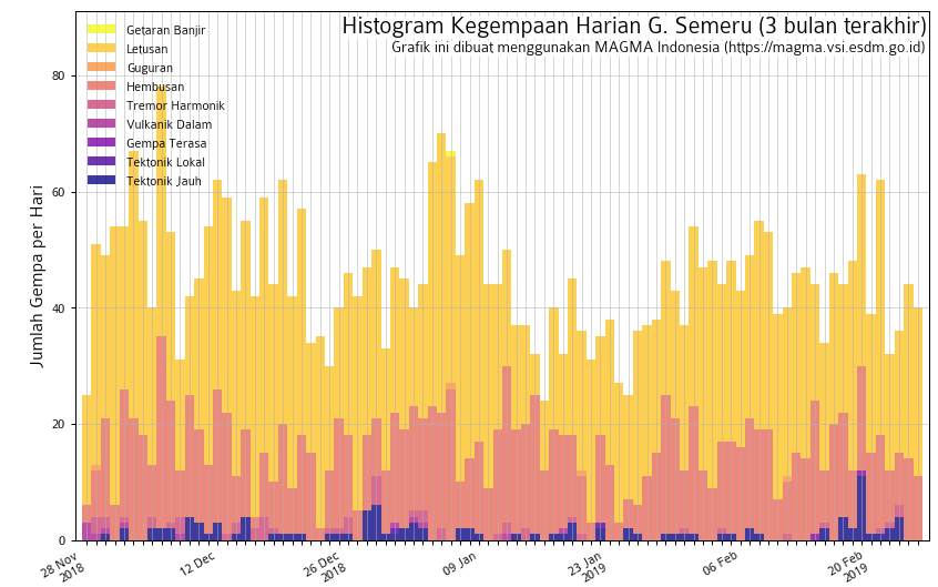 |
Figure 35. Seismicity recorded at Semeru during 28 November 2018-26 February 2019. Plot shows explosion earthquakes ('Letusan'), emission-related events ('Hembusan'), felt earthquakes ('Gempa Terasa'), local tectonic events ('Tektonic Lokal'), and distant tectonic events ('Tektonic Jauh'). Courtesy of PVMBG and MAGMA Indonesia. |
Table 23. Summary of ash plumes at Semeru during 25 August 2018 through February 2019. The summit is at 3,657 m elevation. Data courtesy of Darwin VAAC.
| Date | Plume altitude (km) | Plume drift | Remarks |
| 04 Sep 2018 | 4.3 | W | -- |
| 06-07 Sep 2018 | 4.3 | SW | -- |
| 19 Sep 2018 | 4 | SSW | Possible ash-and-steam plume. |
| 12 Oct 2018 | 4.5 | W | Discrete eruption. |
| 24 Feb 2019 | 4.3 | W | Discrete volcanic ash eruption. |
Thermal anomalies using MODIS satellite instruments processed by the MODVOLC algorithm were only recorded on 26, 28, and 30 August 2018, and 22 and 31 October 2018. The MIROVA (Middle InfraRed Observation of Volcanic Activity) system detected numerous hotspots within 5 km of the volcano during August and early September, with a significant decrease in frequency through October (figure 36); only a few scattered hotspots were recorded from November 2018 through February 2019.
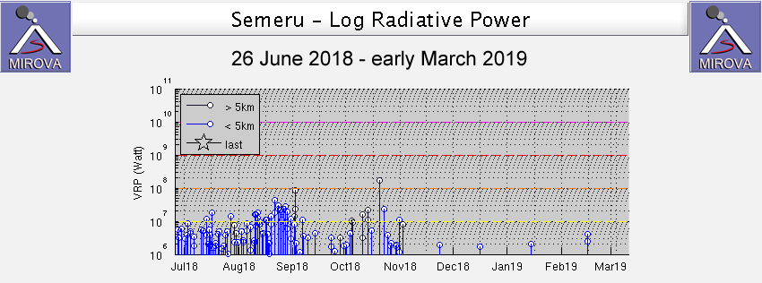 |
Figure 36. MIROVA plot of thermal anomalies (Log Radiative Power) at Semeru during July 2018-February 2019. Courtesy of MIROVA. |
Geological Summary. Semeru, the highest volcano on Java, and one of its most active, lies at the southern end of a volcanic massif extending north to the Tengger caldera. The steep-sided volcano, also referred to as Mahameru (Great Mountain), rises above coastal plains to the south. Gunung Semeru was constructed south of the overlapping Ajek-ajek and Jambangan calderas. A line of lake-filled maars was constructed along a N-S trend cutting through the summit, and cinder cones and lava domes occupy the eastern and NE flanks. Summit topography is complicated by the shifting of craters from NW to SE. Frequent 19th and 20th century eruptions were dominated by small-to-moderate explosions from the summit crater, with occasional lava flows and larger explosive eruptions accompanied by pyroclastic flows that have reached the lower flanks of the volcano.
Information Contacts: Pusat Vulkanologi dan Mitigasi Bencana Geologi (PVMBG, also known as Indonesian Center for Volcanology and Geological Hazard Mitigation, CVGHM), Jalan Diponegoro 57, Bandung 40122, Indonesia (URL: http://www.vsi.esdm.go.id/); MAGMA Indonesia, Kementerian Energi dan Sumber Daya Mineral (URL: https://magma.vsi.esdm.go.id/); Darwin Volcanic Ash Advisory Centre (VAAC), Bureau of Meteorology, Northern Territory Regional Office, PO Box 40050, Casuarina, NT 0811, Australia (URL: http://www.bom.gov.au/info/vaac/); MIROVA (Middle InfraRed Observation of Volcanic Activity), a collaborative project between the Universities of Turin and Florence (Italy) supported by the Centre for Volcanic Risk of the Italian Civil Protection Department (URL: http://www.mirovaweb.it/); Hawai'i Institute of Geophysics and Planetology (HIGP) - MODVOLC Thermal Alerts System, School of Ocean and Earth Science and Technology (SOEST), Univ. of Hawai'i, 2525 Correa Road, Honolulu, HI 96822, USA (URL: http://modis.higp.hawaii.edu/).