Report on Kerinci (Indonesia) — June 2019
Bulletin of the Global Volcanism Network, vol. 44, no. 6 (June 2019)
Managing Editor: Edward Venzke.
Edited by A. Elizabeth Crafford.
Kerinci (Indonesia) Intermittent explosions with ash plumes, February-May 2019
Please cite this report as:
Global Volcanism Program, 2019. Report on Kerinci (Indonesia) (Crafford, A.E., and Venzke, E., eds.). Bulletin of the Global Volcanism Network, 44:6. Smithsonian Institution. https://doi.org/10.5479/si.GVP.BGVN201906-261170
Kerinci
Indonesia
1.697°S, 101.264°E; summit elev. 3800 m
All times are local (unless otherwise noted)
Frequently active, Indonesia's Mount Kerinci on Sumatra has been the source of numerous moderate explosive eruptions since its first recorded eruption in 1838. Intermittent explosions with ash plumes, usually multiple times per month, have characterized activity since April 2018. Similar activity continued during February-May 2019, the period covered in this report with information provided primarily by the Indonesian volcano monitoring agency, Pusat Vulkanologi dan Mitigasi Bencana Geologi (PVMBG, also known as Indonesian Center for Volcanology and Geological Hazard Mitigation, CVGHM), MAGMA Indonesia, notices from the Darwin Volcano Ash Advisory Center (Darwin VAAC), and satellite data. PVMBG has maintained an Alert Level II (of 4) at Kerinci for several years.
On 13 February 2019 the Kerinci Volcano Observatory (KVO), part of PVMBG, noted a brownish-white ash emission that was drifting NE about 400 m above the summit. The seismicity during the event was dominated by continuous volcanic tremor. A brown ash emission was reported on 7 March 2019 that rose to 3.9 km altitude and drifted NE. Ash also drifted 1,300 m down the SE flank. Another ash plume the next morning drifted W at 4.5 km altitude, according to KVO. On 10, 11, and 13 March KVO reported brown ash plumes drifting NE from the summit at about 4.0-4.3 km altitude. The Darwin VAAC observed continuous ash emissions in satellite imagery on 15 March drifting W at 4.3 m altitude that dissipated after about 3 hours (figure 10). A gray ash emission was reported on 19 March about 600 m above the summit drifting NE; local news media noted that residents of Kayo Aro reported emissions on both 18 and 19 March (figure 11). An ash emission appeared in satellite imagery on 25 March (figure 10). On 30 March the observatory reported two ash plumes; a brown emission at 0351 UTC and a gray emission at 0746 UTC that both drifted NE at about 4.4 km altitude and dissipated within a few hours. PVMBG reported another gray ash plume the following day at a similar altitude.
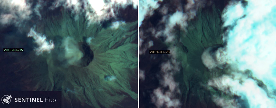 |
Figure 10. Sentinel-2 satellite imagery of Kerinci from 15 (left) and 25 (right) March 2019 showed evidence of ash plumes rising from the summit. Kerinci's summit crater is about 500 m wide. "Geology" rendering (bands 12, 4, 2), courtesy of Sentinel Hub Playground. |
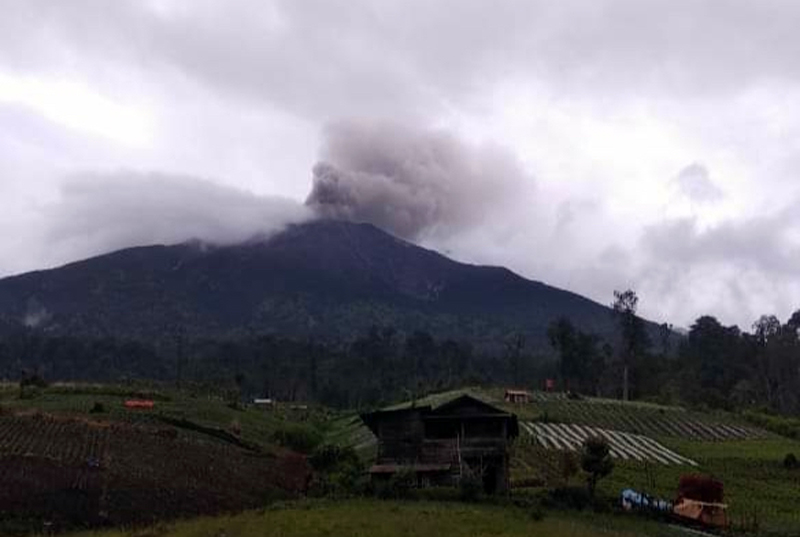 |
Figure 11. Dense ash plumes from Kerinci were reported by local news media on 18 and 19 March 2019. Courtesy of Nusana Jambi. |
Activity continued during April with a brown ash emission reported on 3 April by several different agencies; the Darwin VAAC and PVMBG daily reports noted that the plume was about 500 m above the summit (4.3 km altitude) drifting NE. KVO observed two brown ash emissions on 13 April (UTC) that rose to 4.2 km altitude and drifted NE. Satellite imagery showed minor ash emissions from the summit on 14 April; steam plumes 100-500 m above the summit characterized activity for the remainder of April (figure 12).
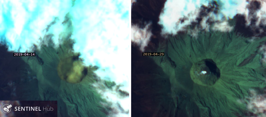 |
Figure 12. A dilute ash emission rose from the summit of Kerinci on 14 April 2019 (left); only steam emissions were present on a clear 29 April in Sentinel-2 imagery (right). "Geology" rendering (bands 12, 4, 2), courtesy of Sentinel Hub Playground. |
Ashfall on the NE and S flanks within 7 km of the volcano was reported on 2 May 2019. According to a news article, at least five villages were affected late on 2 May, including Tanjung Bungo, Sangir, Sangir Tengah, Sungai Rumpun, and Bendung Air (figures 13 and 14). The smell of sulfur was apparent in the villages. Brown ash emissions were observed on 3 and 4 May that rose to 4.6 and 4.1 km altitude and drifted SE. The Darwin VAAC reported an emission on 5 May, based on a pilot report, that rose to 6.7 km altitude and drifted NE for about an hour before dissipating. A brown ash emission on 10 May rose 700 m above the summit and drifted SE. Satellite imagery captured ash emissions from the summit on 14 and 24 May (figure 15). For the remainder of the month, 300-700-m-high dense steam plumes were noted daily until PVMBG reported white and brown plumes on 26 and 27 May rising 500-1,000 m above the summit. Although thermal anomalies were not reported during the period, persistent weak SO2 emissions were identified in TROPOMI instrument satellite data multiple times per month (figure 16).
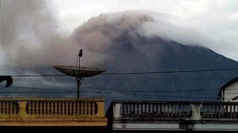 |
Figure 13. Ashfall was reported from five villages on the flanks of Kerinci on 2 May 2019. Courtesy of Uzone. |
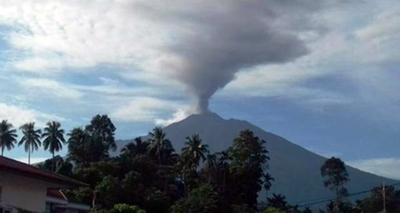 |
Figure 14. An ash plume at Kerinci rose hundreds of meters on 2 May 2019; ashfall was reported in several nearby villages. Courtesy of Kerinci Time. |
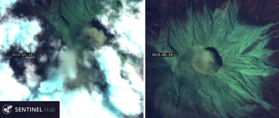 |
Figure 15. Ash emissions from Kerinci were captured in Sentinel-2 satellite imagery on 14 (left) and 24 (right) May 2019. The summit crater is about 500 m wide. "Geology" rendering (bands 12, 4, 2), courtesy of Sentinel Hub Playground. |
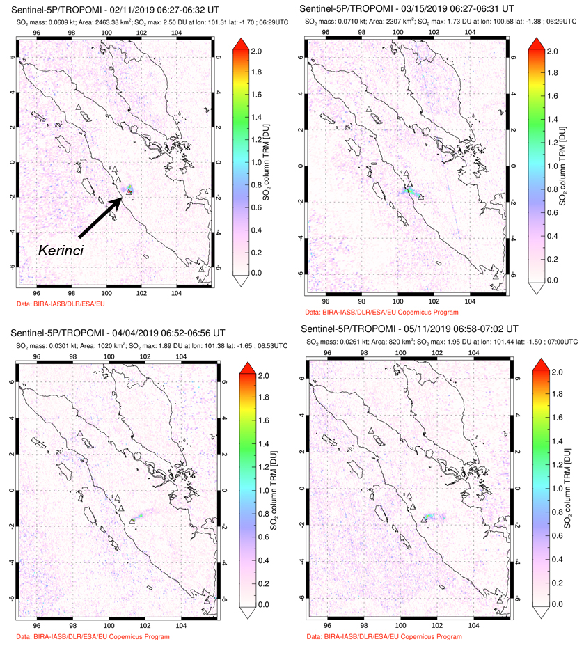 |
Figure 16. Weak SO2 anomalies from Kerinci emissions were captured by the TROPOMI instrument on the Sentinel-5P satellite multiple times each month from February to May 2019. Courtesy of NASA Goddard Space Flight Center. |
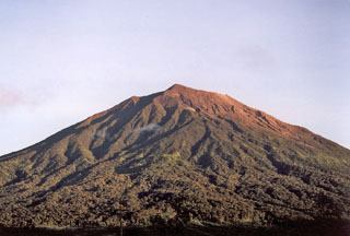
Geological Summary. Gunung Kerinci in central Sumatra forms Indonesia's highest volcano and is one of the most active in Sumatra. It is capped by an unvegetated young summit cone that was constructed NE of an older crater remnant. There is a deep 600-m-wide summit crater often partially filled by a small crater lake that lies on the NE crater floor, opposite the SW-rim summit. The massive 13 x 25 km wide volcano towers 2400-3300 m above surrounding plains and is elongated in a N-S direction. Frequently active, Kerinci has been the source of numerous moderate explosive eruptions since its first recorded eruption in 1838.
Information Contacts: Pusat Vulkanologi dan Mitigasi Bencana Geologi (PVMBG, also known as Indonesian Center for Volcanology and Geological Hazard Mitigation, CVGHM), Jalan Diponegoro 57, Bandung 40122, Indonesia (URL: http://www.vsi.esdm.go.id/); MAGMA Indonesia, Kementerian Energi dan Sumber Daya Mineral (URL: https://magma.vsi.esdm.go.id/); Sentinel Hub Playground (URL: https://www.sentinel-hub.com/explore/sentinel-playground); Global Sulfur Dioxide Monitoring Page, Atmospheric Chemistry and Dynamics Laboratory, NASA Goddard Space Flight Center (NASA/GSFC), 8800 Greenbelt Road, Goddard, Maryland, USA (URL: https://so2.gsfc.nasa.gov/); Nuansa Jambi, Informasi Utama Jambi: (URL: https://nuansajambi.com/2019/03/20/gunung-kerinci-semburkan-asap-tebal/); Kerinci Time (URL: https://kerincitime.co.id/gunung-kerinci-semburkan-abu-vulkanik.html); Uzone.id (URL: https://news.uzone.id/gunung-kerinci-erupsi-5-desa-tertutup-abu-tebal).