Report on Colima (Mexico) — August 2019

Bulletin of the Global Volcanism Network, vol. 44, no. 8 (August 2019)
Managing Editor: Edward Venzke.
Research and preparation by Kadie Bennis.
Colima (Mexico) Renewed volcanism after two years of quiet; explosion on 11 May 2019
Please cite this report as:
Global Volcanism Program, 2019. Report on Colima (Mexico) (Venzke, E., ed.). Bulletin of the Global Volcanism Network, 44:8. Smithsonian Institution. https://doi.org/10.5479/si.GVP.BGVN201908-341040
Colima
Mexico
19.514°N, 103.62°W; summit elev. 3850 m
All times are local (unless otherwise noted)
Frequent historical eruptions at Volcán de Colima date back to the 16th century and include explosive activity, lava flows, and large debris avalanches. The most recent eruptive episode began in January 2013 and continued through March 2017. Previous reports have covered activity involving ash plumes with extensive ashfall, lava flows, lahars, and pyroclastic flows (BGVN 41:01 and 42:08). In late April 2019, increased seismicity related to volcanic activity began again. This report covers activity through July 2019. The primary source of information was the Centro Universitario de Estudios e Investigaciones de Vulcanologia, Universidad de Colima (CUEIV-UdC).
On 11 May 2019, CUEIV-UdC reported an explosion that was recorded by several monitoring stations. A thermal camera located south of Colima captured thermal anomalies associated with the explosion as well as intermittent degassing, which mainly consisted of water vapor (figure 134). A report from the Unidad Estatal de Protección Civil de Colima (UEPCC), and seismic and infrasound network data from CUEIV-UdC, recorded about 60 high-frequency events, 16 landslides, and 14 low-magnitude explosions occurring on the NE side of the crater during 11-24 May. Drone imagery showed fumarolic activity occurring on the inner wall of this crater on 22 May (figure 135).
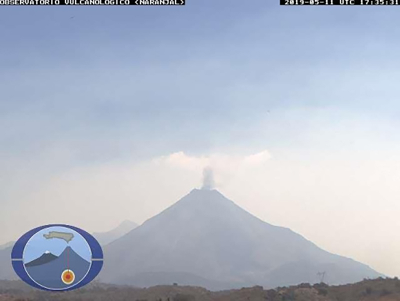 |
Figure 134. Gas emissions from Colima during the 11 May 2019 eruption as seen from the Naranjal station. Courtesy of CUEIV-UdC (Boletin Seminal de la Actividad del Volcan de Colima 17 mayo 2019 no 121). |
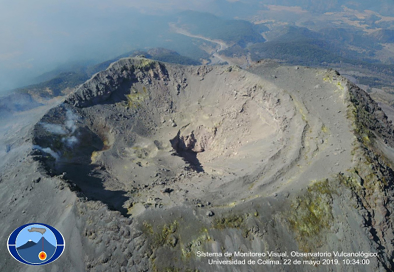 |
Figure 135. A drone photo showing fumarolic activity occurring within the NE wall of the crater at Colima on 22 May 2019. Courtesy of CUEIV-UdC (Boletin Seminal de la Actividad del Volcan de Colima 24 mayo 2019 no 122). |
Small explosions and gas-and-steam emissions continued intermittently through mid-July 2019 concentrated on the NE side of the crater. An overflight on 9 July 2019 revealed that subsidence from the consistent activity slightly increased the diameter of the vent; other areas within the crater also showed evidence of subsidence and some collapsed material on the outer W wall (figure 136). During the weeks of 19 and 26 July 2019, monitoring cameras and seismic data recorded eight lahars.
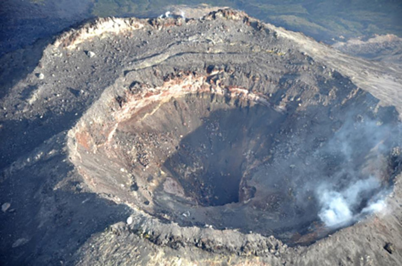 |
Figure 136. A drone photo of the crater at Colima on 8 July 2019 shows continuing fumarolic activity and evidence of a collapsed wall on the W exterior side. Courtesy of CUEIV-UdC (Boletin Seminal de la Actividad del Volcan de Colima 12 julio 2019 no 129). |
Geological Summary. The Colima complex is the most prominent volcanic center of the western Mexican Volcanic Belt. It consists of two southward-younging volcanoes, Nevado de Colima (the high point of the complex) on the north and the historically active Volcán de Colima at the south. A group of late-Pleistocene cinder cones is located on the floor of the Colima graben west and east of the complex. Volcán de Colima (also known as Volcán Fuego) is a youthful stratovolcano constructed within a 5-km-wide scarp, breached to the south, that has been the source of large debris avalanches. Major slope failures have occurred repeatedly from both the Nevado and Colima cones, producing thick debris-avalanche deposits on three sides of the complex. Frequent recorded eruptions date back to the 16th century. Occasional major explosive eruptions have destroyed the summit (most recently in 1913) and left a deep, steep-sided crater that was slowly refilled and then overtopped by lava dome growth.
Information Contacts: Centro Universitario de Estudios e Investigaciones de Vulcanologia, Universidad de Colima (CUEIV-UdC), Colima, Col. 28045, Mexico; Centro Universitario de Estudios Vulcanologicos y Facultad de Ciencias de la Universidad de Colima, Avenida Universidad 333, Colima, Col. 28045, Mexico (URL: http://portal.ucol.mx/cueiv/); Unidad Estatal de Protección Civil, Colima, Roberto Esperón No. 1170 Col. de los Trabajadores, C.P. 28020, Mexico (URL: http://www.proteccioncivil.col.gob.mx/).