Lateiki
Tonga
19.18°S, 174.87°W; summit elev. 43 m
All times are local (unless otherwise noted)
Lateiki (Metis Shoal) is one of several submarine and island volcanoes on the W side of the Tonga trench in the South Pacific. It has produced ephemeral islands multiple times since the first confirmed activity in the mid-19th century. Two eruptions, in 1967 and 1979, produced islands that survived for a few months before eroding beneath the surface. An eruption in 1995 produced a larger island that persisted, possibly until a new eruption in mid-October 2019 destroyed it and built a new short-lived island. Information was provided by the Ministry of Lands, Survey and Natural Resources of the Government of the Kingdom of Tonga, and from satellite information and news sources.
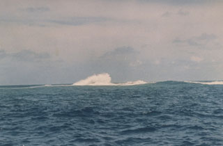
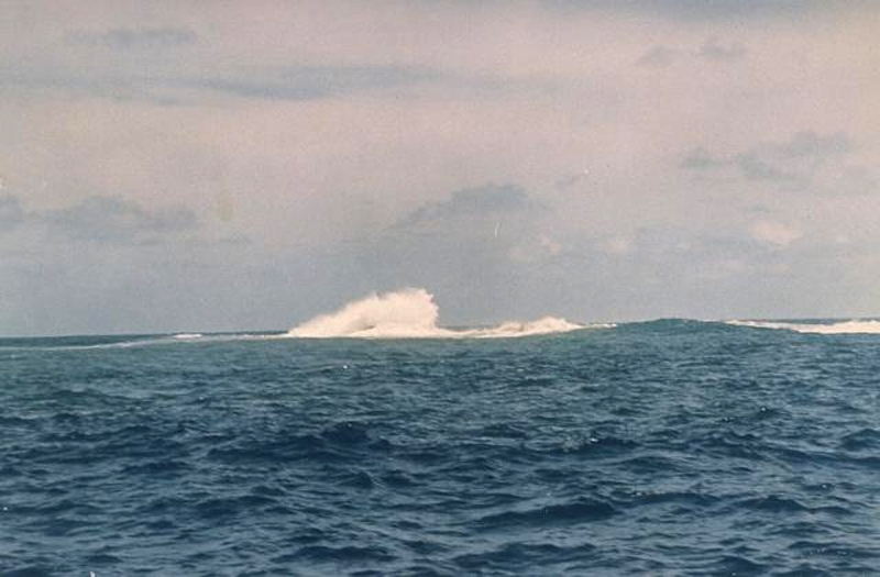
Review of eruptions during 1967-1995. The first reported 20th century eruption at this location was observed by sailors beginning on 12 December 1967 (CSLP 02-67); incandescent ejecta rose several hundred meters into the air and "steam and smoke" rose at least 1,000 m from the ocean surface. The eruption created a small island that was reported to be a few tens of meters high, and a few thousand meters in length and width. Eruptive activity appeared to end in early January 1968, and the island quickly eroded beneath the surface by the end of February (figure 6). When observed in April 1968 the island was gone, with only plumes of yellowish water in the area of the former island.
A large steam plume and ejecta were observed on 19 June 1979, along with a "growing area of tephra" around the site with a diameter of 16 km by the end of June (SEAN 04:06). Geologists visited the site in mid-July and at that time the island was about 300 m long, 120 m wide, and 15 m high, composed of tephra ranging in size from ash to large bombs (SEAN 04:07); ash emissions were still occurring from the E side of the island. It was determined that the new island was located about 1 km E of the 1967-68 island. By early October 1979 the island had nearly disappeared beneath the ocean surface.
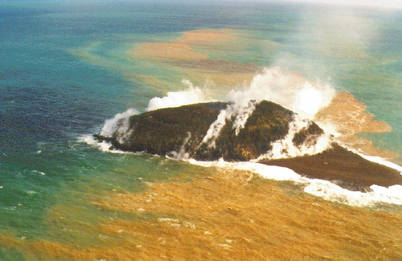
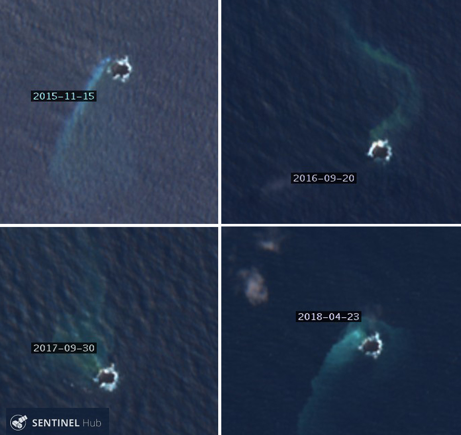
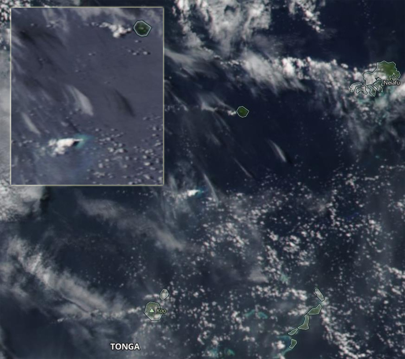
A new eruption was first observed on 6 June 1995. A new island appeared above the waves as a growing lava dome on 12 June (BGVN 20:06). Numerous ash plumes rose hundreds of meters and dissipated downwind. By late June an elliptical dome, about 300 x 250 m in size and 50 m high, had stopped growing. The new island it formed was composed of hardened lava and not the tuff cones of earlier islands (figure 7) according to visitors to the island; pumice was not observed. An overflight of the area in December 2006 showed that an island was still present (figure 8), possibly from the June 1995 eruption. Sentinel-2 satellite imagery confirming the presence of Lateiki Island and discolored water was clearly recorded multiple times between 2015 and 2019. This suggests that the island created in 1995 could have lasted for more than 20 years (figure 9).
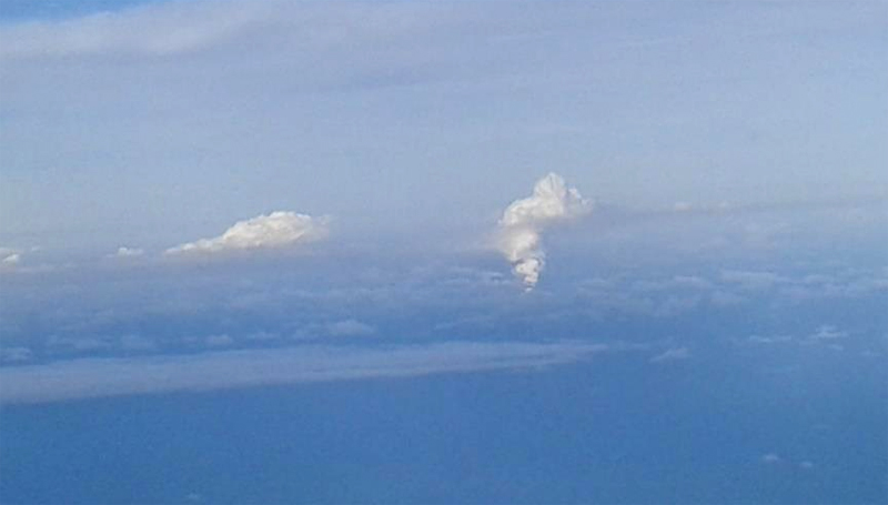
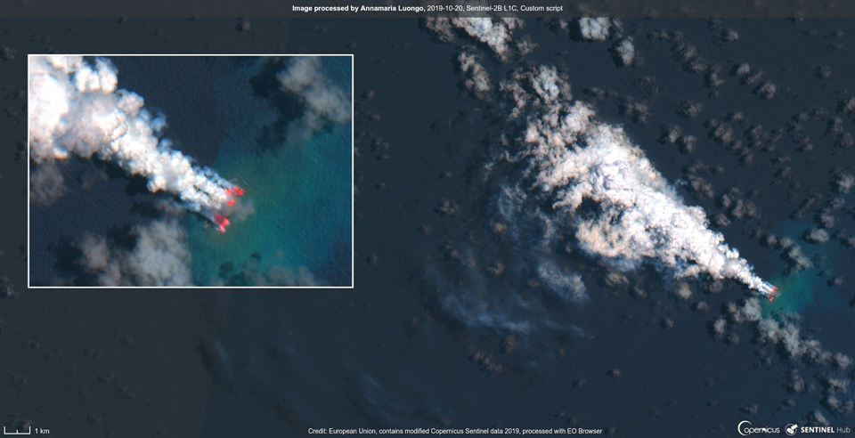
New eruption in October 2019. The Kingdom of Tonga reported a new eruption at Lateiki on 13 October 2019, first noted by a ship at 0800 on 14 October. NASA satellite imagery confirmed the eruption taking place that day (figure 10). The following morning a pilot from Real Tonga Airlines photographed the steam plume and reported a plume height of 4.6-5.2 km altitude (figure 11). The Wellington VAAC issued an aviation advisory report noting the pilot's observation of steam, but no ash plume was visible in satellite imagery. They issued a second report on 22 October of a similar steam plume reported by a pilot at 3.7 km altitude. The MODVOLC thermal alert system recorded three thermal alerts from Lateiki, one each on 18, 20, and 22 October 2019.
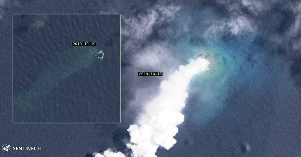
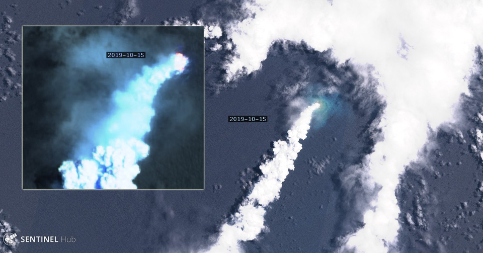
The first satellite image of the eruption on 15 October 2019 showed activity over a large area, much bigger than the preexisting island that was visible on 10 October (figure 12). Although the eruption produced a steam plume that drifted several tens of kilometers SW and strong incandescent activity, no ash plume was visible, similar to reports of dense steam with little ash during the 1968 and 1979 eruptions (figure 13). Strong incandescence and a dense steam plume were still present on 20 October (figure 14).
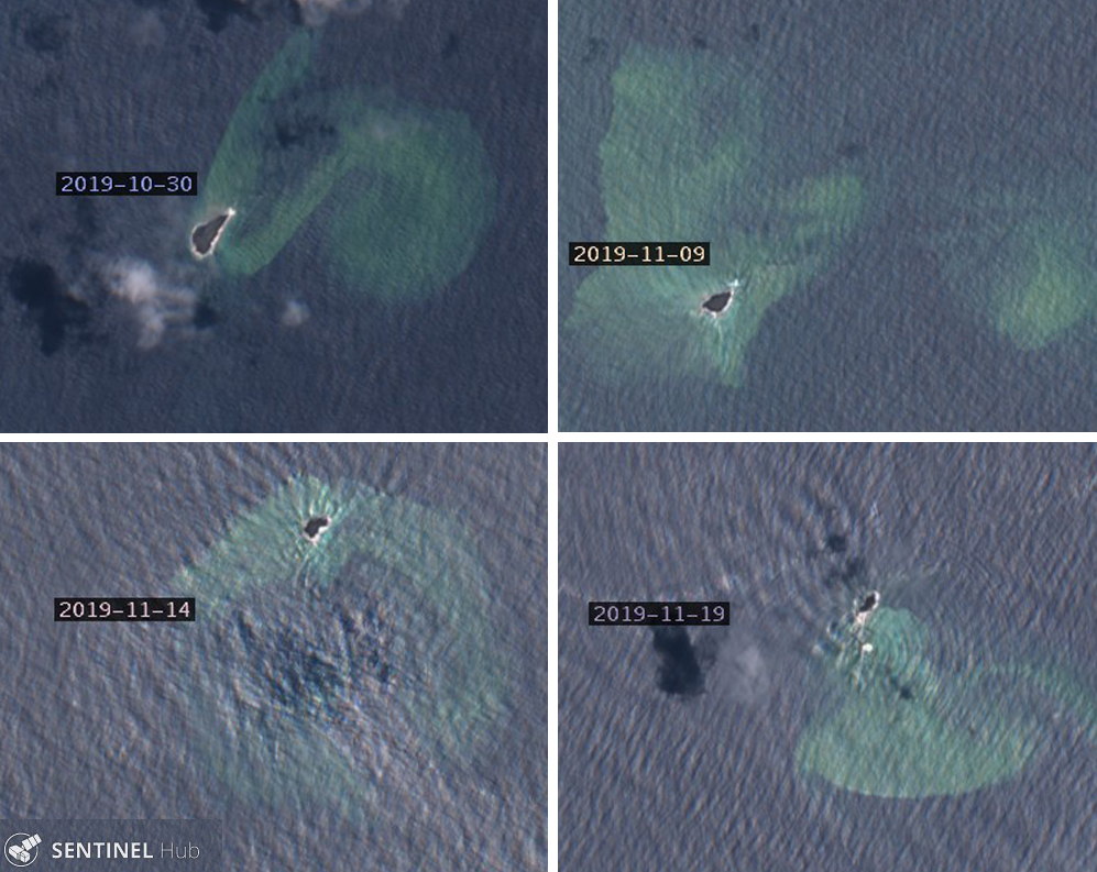
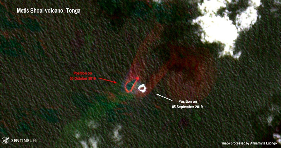
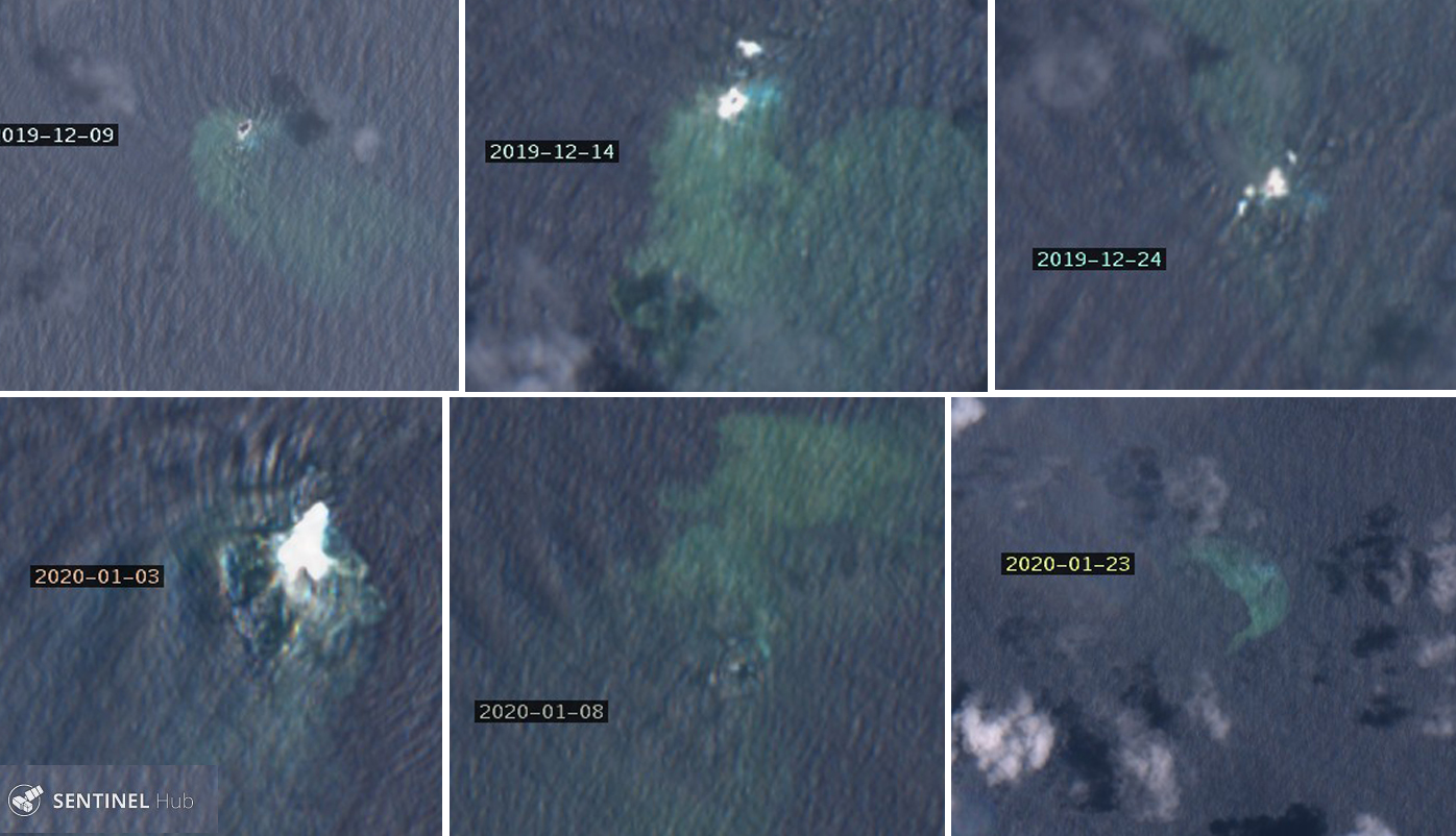
A clear satellite image on 30 October 2019 revealed an island estimated to be about 100 m wide and 400 m long, according to geologist Taaniela Kula of the Tonga Geological Service of the Ministry of Lands, Survey and Natural Resources as reported by a local news source (Matangitonga). There was no obvious fumarolic steam activity from the surface, but a plume of greenish brown seawater swirled away from the island towards the NE (figure 15). In a comparison of the location of the old Lateiki island with the new one in satellite images, it was clear that the new island was located as far as 250 m to the NW (figure 16) on 30 October. Over the course of the next few weeks, the island's size decreased significantly; by 19 November, it was perhaps one-quarter the size it had been at the end of October. Lateiki Island continued to diminish during December 2019 and January 2020, and by mid-month only traces of discolored sea water were visible beneath the waves over the eruption site (figure 17).
Geological Summary. Lateiki, previously known as Metis Shoal, is a submarine volcano midway between the islands of Kao and Late that has produced a series of ephemeral islands since the first confirmed activity in the mid-19th century. An island, perhaps not in eruption, was reported in 1781 and subsequently eroded away. During periods of inactivity following 20th-century eruptions, waves have been observed to break on rocky reefs or sandy banks with depths of 10 m or less. Dacitic tuff cones formed during the eruptions in 1967 and 1979 were soon eroded beneath the ocean surface. An eruption in 1995 produced an island with a diameter of 280 m and a height of 43 m following growth of a lava dome above the surface.
Information Contacts: Government of the Kingdom of Tonga, PO Box 5, Nuku'alofa, Tonga (URL: http://www.gov.to/ ); Royal New Zealand Air Force (URL: http://www.airforce.mil.nz/); NASA Worldview (URL: https://worldview.earthdata.nasa.gov/); Hawai'i Institute of Geophysics and Planetology (HIGP) - MODVOLC Thermal Alerts System, School of Ocean and Earth Science and Technology (SOEST), Univ. of Hawai'i, 2525 Correa Road, Honolulu, HI 96822, USA (URL: http://modis.higp.hawaii.edu/); Sentinel Hub Playground (URL: https://www.sentinel-hub.com/explore/sentinel-playground); Annamaria Luongo, Brussels, Belgium (Twitter: @annamaria_84, URL: https://twitter.com/annamaria_84 ); Taaniela Kula, Tonga Geological Service, Ministry of Lands, Survey and Natural Resources; Matangi Tonga Online (URL: https://matangitonga.to/2019/11/06/eruption-lateiki).