Report on Shishaldin (United States) — October 1975
Natural Science Event Bulletin, vol. 1, no. 1 (October 1975)
Managing Editor: David Squires.
Shishaldin (United States) Ash eruptions; continuous activity in September and into October
Please cite this report as:
Global Volcanism Program, 1975. Report on Shishaldin (United States) (Squires, D., ed.). Natural Science Event Bulletin, 1:1. Smithsonian Institution. https://doi.org/10.5479/si.GVP.NSEB197510-311360
Shishaldin
United States
54.756°N, 163.97°W; summit elev. 2857 m
All times are local (unless otherwise noted)
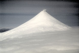
Shishaldin, during the few times it could be observed from Cold Bay, was seen to be continually active in September and into October. At 2215 on 16 September, NOAA's RV Millard Freeman, at 55.55°N, 163.82°W experienced rainfall that contained ash. This continued for 15 minutes while the ship was headed on course 250° true. The ash eruptions had apparently ceased by the end of October.
Geological Summary. The symmetrical glacier-covered Shishaldin in the Aleutian Islands is the westernmost of three large stratovolcanoes in the eastern half of Unimak Island. The Aleuts named the volcano Sisquk, meaning "mountain which points the way when I am lost." Constructed atop an older glacially dissected edifice, it is largely basaltic in composition. Remnants of an older edifice are exposed on the W and NE sides at 1,500-1,800 m elevation. There are over two dozen pyroclastic cones on its NW flank, which is covered by massive aa lava flows. Frequent explosive activity, primarily consisting of Strombolian ash eruptions from the small summit crater, but sometimes producing lava flows, has been recorded since the 18th century. A steam plume often rises from the summit crater.
Information Contacts: P. Sventek, USAF, Cold Bay; T. Miller, USGS, Anchorage.