Report on Taal (Philippines) — September 1976

Natural Science Event Bulletin, vol. 1, no. 12 (September 1976)
Managing Editor: David Squires.
Taal (Philippines) Precursors trigger evacuation before explosive eruptions in early September
Please cite this report as:
Global Volcanism Program, 1976. Report on Taal (Philippines) (Squires, D., ed.). Natural Science Event Bulletin, 1:12. Smithsonian Institution. https://doi.org/10.5479/si.GVP.NSEB197609-273070
Taal
Philippines
14.0106°N, 120.9975°E; summit elev. 311 m
All times are local (unless otherwise noted)
COMVOL scientists monitoring Taal during late August noted the following signs of increased activity: profuse steaming from the junction of the SW portion of the 1966-70 eruption cone and the western rim of the pre-1965 lagoon (figure 1); visible ground heating at some points above the pre-1965 lagoon; and a rise in the temperature of some ground probes in the area to 95°C. As a result of these observations, the evacuation of several thousand persons from Taal Island ("Volcano Island" on figures 1 and 2) and some lakeshore towns was recommended on 31 August.
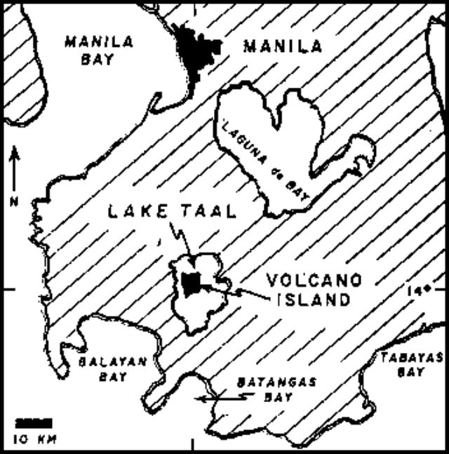 |
Figure 1. Index map showing the area around Taal, after Moxham (1967). Land area is shaded. |
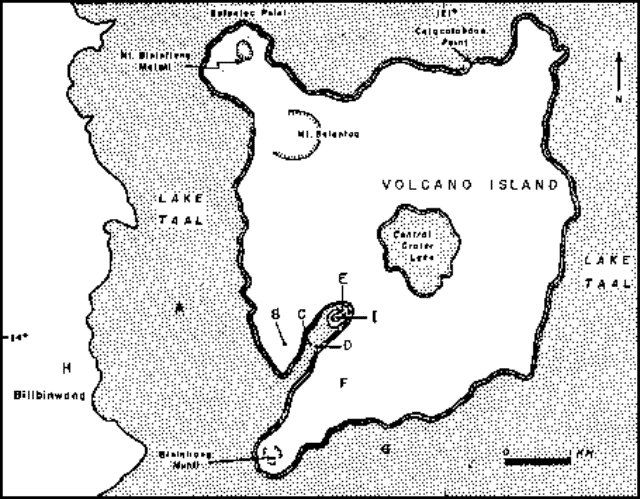 |
Figure 2. Map of Taal Island and vicinity, October 1965, after Moxham (1967). The 1965 explosion crater extends SW from I; the 1966 explosion crater formed immediately to the NW. |
2 September: Steaming increased at the 1966-70 eruption site and at the main crater. The area of steaming had expanded considerably, particularly to the SW. A fissure widened from 5 to 20 cm and lengthened from 50 to 100 m. Seismic activity was low.
3 September: An eruption of steam and ash began at about 0430 from Mt. Tabaro vent, a few meters SW of the site of 1966-70 activity. Eruptions occurred at about 4-minute intervals, producing clouds 1,500-3,000 m high. Harmonic tremor accompanied the activity. Evacuation had been completed at 0400.
4 September: Eruptive activity ceased at 0500. Renewed steam and ash emission occurred between 0900 and 0920 and again at 1300; the latter included some large fragments and produced a cloud 300-400 m high. Harmonic tremor was recorded during eruptions. Brownish ash blanketed the S half of the island to an unknown depth.
5 September: Individual eruptive bursts contained a greater proportion of ash and large fragments than those of previous days. No incandescent material or rumbling was observed. During the morning, eruption periods were longer than the repose periods separating them; by late afternoon, eruptions lasted about 3 minutes, followed by about 5 minutes of repose. Eruptions were nearly vertical with a slight southward component; the resulting clouds reached more than 2,000 m in the morning, but were limited to 300 m by strong SW winds in the afternoon. Late-afternoon rain caused steaming to intensify. Continuous harmonic tremor of 4 mm amplitude was recorded. The new vent was enlarged by coalescence with the adjacent cone.
6 September: Harmonic tremor amplitudes began to increase at 0330 to 3-10 mm. Emission of black, grayish-black, or reddish-brown ash-laden eruption clouds was continuous, accompanied by faint rumbling and occasional brief lightning flashes just above the vent. The eruption clouds, which contained some large rock fragments, averaged 200-300 m, reaching a maximum of 2,200 m in the early morning. Activity had slackened by afternoon, when maximum eruption cloud height was slightly more than 500 m, and the diameter was about 50 m. Lower ejection velocity and light wind caused much of the erupted material to collapse and form base surges at the foot of the 1966 cone. Rock fragments up to 30 cm in diameter produced dust clouds on the 1966 cone by impact and downslope rolling. By 1700, activity was still continuous, but the eruption cloud had diminished to 30 m across and less than 500 m high. Maximum harmonic tremor amplitude had declined.
7 September: Steam and ash eruptions continued, generating a 3,000-m cloud and base surges over the SW flank. Harmonic tremor was continuous and had a maximum amplitude of 5 mm. A new fissure opened, measuring 100 m x 20 cm.
8 September: After a midmorning period of quiescence, a new vent opened a few meters SW of the active vent of the past several days. Ash and larger fragments were ejected to 250 m height. Maximum harmonic tremor amplitude increased to 8 mm.
9 September: The strongest explosion of the eruption produced base surges that moved over the 1965 and 1966 craters. Harmonic tremor amplitudes rose from 5 to 9 mm shortly before the explosion, and reached a maximum of 12 mm during the explosion. By late afternoon, eruptive force had declined, but ash emission was still continuous and voluminous. Strong west winds carried the ash across Lake Taal to its E shore.
10 September: At 2331, incandescent gases and some incandescent fragments were noted for the first time, accompanied by a continuous hollow sound. Steam and ash emission continued.
11 September: Minor fountaining and incandescent ash clouds were observed. Steam and ash emission continued.
Reference. Moxham, R.M., 1967, Changes in surface temperature at Taal volcano, Philippines 1965-1966: BV, v. 31, p. 215-234.
Geological Summary. Taal is one of the most active volcanoes in the Philippines and has produced some powerful eruptions. The 15 x 20 km Talisay (Taal) caldera is largely filled by Lake Taal, whose 267 km2 surface lies only 3 m above sea level. The maximum depth of the lake is 160 m, with several submerged eruptive centers. The 5-km-wide Volcano Island in north-central Lake Taal is the location of all observed eruptions. The island is composed of coalescing small stratovolcanoes, tuff rings, and scoria cones. Powerful pyroclastic flows and surges have caused many fatalities.
Information Contacts: G. Andal, COMVOL, Quezon City; W. Ward, HQ 13th Air Force (PACAF); D. Shackelford, Villa Park, CA.