Report on Kavachi (Solomon Islands) — October 1976
Natural Science Event Bulletin, vol. 1, no. 13 (October 1976)
Managing Editor: David Squires.
Kavachi (Solomon Islands) Pyroclastic eruptions continue through September
Please cite this report as:
Global Volcanism Program, 1976. Report on Kavachi (Solomon Islands) (Squires, D., ed.). Natural Science Event Bulletin, 1:13. Smithsonian Institution. https://doi.org/10.5479/si.GVP.NSEB197610-255060
Kavachi
Solomon Islands
8.991°S, 157.979°E; summit elev. -20 m
All times are local (unless otherwise noted)
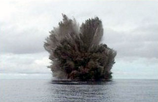
The lava flow, which began on 7 September when the cone first built itself above sea level, ceased between 9 and 11 September. Pyroclastic eruptions continued, with small bursts every 30 seconds and larger ones every 2 minutes. "Smoke" emission was continuous. Tephra deposition had filled the breach in the SE wall of the crater by 15 September. Photographs taken on that date show an elongate island (NW-SE) about 100 m in length. Pyroclastic activity lasted until at least 1 October, maintaining its 30-second and 2-minute periodicity. No pumice was reported. Cone height stabilized at 15-20 m, with accretion of tephra compensating for erosion by the sea. An observer 24 km away noted no activity on 6 October. A survey to determine the size and position of the new cone was planned for 12 October.
A temporary seismological station installed on Vakambo Island (8.37°S, 157.85°E, near New Georgia Island 73 km from Kavachi) began recording on 24 September. Twenty earthquakes were recorded 24 September-5 October, all with S-P separations corresponding to Kavachi epicenters, but they cannot be conclusively associated with the eruption since they were not recorded by another station. The station was operated by Deni Tuni.
Geological Summary. Named for a sea-god of the Gatokae and Vangunu peoples, Kavachi is located in the Solomon Islands south of Vangunu Island. Sometimes referred to as Rejo te Kvachi ("Kavachi's Oven"), this shallow submarine basaltic-to-andesitic volcano has produced ephemeral islands up to 1 km long many times since its first recorded eruption during 1939. Residents of the nearby islands of Vanguna and Nggatokae (Gatokae) reported "fire on the water" prior to 1939, a possible reference to earlier eruptions. The roughly conical edifice rises from water depths of 1.1-1.2 km on the north and greater depths to the SE. Frequent shallow submarine and occasional subaerial eruptions produce phreatomagmatic explosions that eject steam, ash, and incandescent bombs. On a number of occasions lava flows were observed on the ephemeral islands.
Information Contacts: R. Thompson, Geological Survey, Honiara.