Report on Taal (Philippines) — November 1976
Natural Science Event Bulletin, vol. 1, no. 14 (November 1976)
Managing Editor: David Squires.
Taal (Philippines) Strong, frequent eruptions with ashfall through mid-October
Please cite this report as:
Global Volcanism Program, 1976. Report on Taal (Philippines) (Squires, D., ed.). Natural Science Event Bulletin, 1:14. Smithsonian Institution. https://doi.org/10.5479/si.GVP.NSEB197611-273070
Taal
Philippines
14.0106°N, 120.9975°E; summit elev. 311 m
All times are local (unless otherwise noted)
Activity continued through September and early October.
13 September: Voluminous quantities of steam and ash were emitted, causing ashfalls at towns up to 10 km E of the vent. Harmonic tremor was continuous. Intermittent incandescence was reported during the previous week.
14 September: Strong steam and ash eruptions continued until evening, when activity slackened.
15 September: Activity increased around 0700. Just before noon, a strong explosion ejected rock fragments 150 m above the vent and produced an 1,800-m ash. Ash fell on towns surrounding Lake Taal, up to 16 km E and N of the vent. One mm of ash fell in a 20-minute period and a strong stench of sulfur was noted at the volcano station, 4 km from the vent.
17 September: Ash fell continuously on towns east and north of Lake Taal, frequently mixing with rain to fall as mud. Heavy ashfall and sulfur fumes forced the evacuation of Taal Island, except for a skeleton staff remaining at the volcano station. Many work animals had died and many others were ill, probably because of sulfur-contaminated food and water. Harmonic tremor gradually increased in amplitude.
18 September: Ash and sulfur emission decreased slightly in the evening.
19 September: Diminished activity allowed an inspection on the vent area. The new crater formed on the first day of the eruption was steaming weakly. Most activity was from a 100-m-diameter vent within the 1965-70 cone, on which scattered impact craters a few centimeters to 0.7 m across were present up to 500 m from the vent. Harmonic tremor amplitude had declined. Ash emission weakened further in the evening, with occasional brief pauses. Ash clouds took 2-3 minutes to rise 700 m.
20 September: Continuous eruption resumed in the morning. No incandescence was observed. Harmonic tremor amplitude was unchanged. About 100 people had eruption-related diseases: asthmatic bronchitis, gastroenteritis, respiratory tract infection, sore eyes, and allergy.
21-22 September: The eruption weakened considerably.
23 September: Steam and ash emission increased in intensity, but no incandescence was observed. Harmonic tremor amplitude increased.
4 October: The eruption resumed after a "short lull." Ash clouds rose more than 2,100 m, accompanied by lightning, thunderstorms, and harmonic tremor.
5 October: Ash emission, in black to brownish clouds, increased. By afternoon, heavy ashfall, which forced cars to use their headlights, had deposited 2.5 cm of ash in one town near Lake Taal.
7 October: Continuous heavy ashfall forced the evacuation of five towns up to 16 km E and N of the vent. The eruption was accompanied by hollow sounds from within the crater and by harmonic tremor. Profuse emission of white steam was occurring from the source of the 1968 lava flow. A new step fault was noted near the summit of the vent.
8 October: Ash-laden steam clouds were ejected continuously to a height of 500-600 m, depositing ash around Lake Taal. Activity had migrated back to the elongate main vent. Harmonic tremor amplitude began to increase at 0330.
10 October: A reconnaissance at 1200 noted ejection of coarser fragments, accompanied by hollow reverberations, lightning, and thunder. Ash fell SW of the vent (most ash had previously fallen to the N and E). Ash eruption ended at 1650.
11 October: Activity resumed at 0100 with the ejection of brownish ash clouds, accompanied by harmonic tremor.
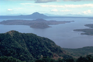
Geological Summary. Taal is one of the most active volcanoes in the Philippines and has produced some powerful eruptions. The 15 x 20 km Talisay (Taal) caldera is largely filled by Lake Taal, whose 267 km2 surface lies only 3 m above sea level. The maximum depth of the lake is 160 m, with several submerged eruptive centers. The 5-km-wide Volcano Island in north-central Lake Taal is the location of all observed eruptions. The island is composed of coalescing small stratovolcanoes, tuff rings, and scoria cones. Powerful pyroclastic flows and surges have caused many fatalities.
Information Contacts: Manila Times-Journal.

