Report on Izu-Torishima (Japan) — January 1977
Natural Science Event Bulletin, vol. 2, no. 1 (January 1977)
Managing Editor: David Squires.
Izu-Torishima (Japan) Possible submarine eruption in October 1975
Please cite this report as:
Global Volcanism Program, 1977. Report on Izu-Torishima (Japan) (Squires, D., ed.). Natural Science Event Bulletin, 2:1. Smithsonian Institution. https://doi.org/10.5479/si.GVP.NSEB197701-284090
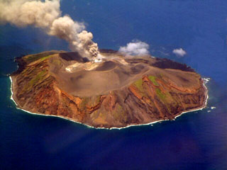
Izu-Torishima
Japan
30.484°N, 140.303°E; summit elev. 394 m
All times are local (unless otherwise noted)
[A table of possible submarine eruptions based on aerial observations of water discoloration by the Japanese Maritime Safety Agency included an entry for 30.38°N, 140.32°E, in October 1975. This location is ~11 km S of Tori-shima.]
Geological Summary. The circular, 2.7-km-wide island of Izu-Torishima in the southern Izu Islands is capped by an unvegetated summit cone formed during an eruption in 1939. Fresh lava flows from this eruption form part of the northern coastline of the basaltic-to-dacitic edifice. The volcano is referred to as Izu-Torishima to distinguish it from the several other Japanese island volcanoes called Torishima ("Bird Island"). The main cone is truncated by a 1.5-km-wide caldera that contains two central cones, of which Ioyama is the highest. Historical eruptions have also occurred from flank vents near the north coast and offshore submarine vents. A submarine caldera 6-8 km wide lies immediately to the north.
Information Contacts: AFP; U.S. Defense Mapping Agency.