Report on Matthew Island (France - claimed by Vanuatu) — July 1977
Natural Science Event Bulletin, vol. 2, no. 7 (July 1977)
Managing Editor: David Squires.
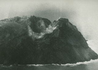
Matthew Island (France - claimed by Vanuatu) Photograph from 11 February showing the vent
Please cite this report as:
Global Volcanism Program, 1977. Report on Matthew Island (France - claimed by Vanuatu) (Squires, D., ed.). Natural Science Event Bulletin, 2:7. Smithsonian Institution. https://doi.org/10.5479/si.GVP.NSEB197707-258010
Matthew Island
France - claimed by Vanuatu
22.33°S, 171.32°E; summit elev. 177 m
All times are local (unless otherwise noted)
[An RNZAF crew flew over Matthew Island on 11 February and photographed the volcano. The vent was weakly emitting vapor (figure 1).]
 |
Figure 1. Photograph taken from the N on 11 February 1977, showing the vent and about 2/3 of Matthew Island. Photograph taken by the Royal New Zealand Air Force (RNZAF). |
Geological Summary. Matthew Island is composed of two low andesitic-to-dacitic cones separated by a narrow isthmus. The Matthew name originates from an English mariner who sighted the island in 1788. Only the triangular eastern portion of the 0.6 x 1.2 km island was present prior to the 1940s, when construction of the larger western segment began; it consists primarily of lava flows. The western cone contains a crater that is breached to the NW and is filled by a lava flow whose terminus forms the NW coast.
Information Contacts: I. Nairn, NZGS, Rotorua.