Report on Monowai (New Zealand) — October 1977
Natural Science Event Bulletin, vol. 2, no. 10 (October 1977)
Managing Editor: David Squires.
Monowai (New Zealand) Water discoloration extending 5 km from area of brown turbulence
Please cite this report as:
Global Volcanism Program, 1977. Report on Monowai (New Zealand) (Squires, D., ed.). Natural Science Event Bulletin, 2:10. Smithsonian Institution. https://doi.org/10.5479/si.GVP.NSEB197710-242050
Monowai
New Zealand
25.887°S, 177.188°W; summit elev. -132 m
All times are local (unless otherwise noted)
Royal New Zealand Air Force (RNZAF) personnel observed submarine volcanic activity at a site above the Tonga Ridge on 13 October at 1430. Discoloration stretched about 5 km SW from a patch of brown, gaseous, turbulent water 200 m in diameter. A sonar buoy dropped into the turbulent water detected pulsating rumbles and an explosion, believed to originate from a source about 4000 m deep. No records exist of previous activity in the area.
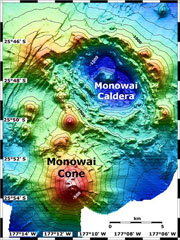
Geological Summary. Monowai, also known as Orion seamount, is a basaltic stratovolcano that rises from a depth of about 1,500 to within 100 m of the ocean surface about halfway between the Kermadec and Tonga island groups, at the southern end of the Tonga Ridge. Small cones occur on the N and W flanks, and an 8.5 x 11 km submarine caldera with a depth of more than 1,500 m lies to the NNE. Numerous eruptions have been identified using submarine acoustic signals since it was first recognized as a volcano in 1977. A shoal that had been reported in 1944 may have been a pumice raft or water disturbance due to degassing. Surface observations have included water discoloration, vigorous gas bubbling, and areas of upwelling water, sometimes accompanied by rumbling noises. It was named for one of the New Zealand Navy bathymetric survey ships that documented its morphology.
Information Contacts: J. Latter, DSIR, Wellington.