Report on Cerro Azul (Ecuador) — February 1979
Scientific Event Alert Network Bulletin, vol. 4, no. 2 (February 1979)
Managing Editor: David Squires.
Cerro Azul (Ecuador) Flank fissure eruption continuing after full month
Please cite this report as:
Global Volcanism Program, 1979. Report on Cerro Azul (Ecuador) (Squires, D., ed.). Scientific Event Alert Network Bulletin, 4:2. Smithsonian Institution. https://doi.org/10.5479/si.GVP.SEAN197902-353060
Cerro Azul
Ecuador
0.92°S, 91.408°W; summit elev. 1640 m
All times are local (unless otherwise noted)
The eruption was at an elevation of approximately 300 m on the E flank of Cerro Azul, a young shield volcano. The earliest report of activity is from fishing boats that were anchored in Iguana Cove, 5 km W of the volcano's caldera, on the night of 29 January. They experienced substantial ashfall overnight, but the first reported glow seen from the village of Villamil, 23 km E of the eruption, was not until two nights later. The eruption site was seen on the morning of 2 February by Howard Snell and Hans Kruuk, who landed on the S coast that afternoon and reached a good viewing position 3-4 km from the vent on 3 February. Lava fountaining reached 300 m above the 20-50-m new crater rim, and fed a lava flow moving SE toward the sea. The main vent was 6 km E of the caldera center, near the low point between Cerro Azul and Sierra Negra volcanoes. This area was the site of recent eruptions (apparently in 1952 or the 1940's) that fed lava flows toward the sea both to the NW and SE, forming a narrow lava barrier on the otherwise vegetated low landscape between the two volcanoes. The main 1979 vent was several hundred meters into this older lava, and the new flow moved SE along the SW margin of the older flow. The flow front advanced an estimated 1-2 km during the night of 4-5 February. Another vent, roughly 400-500 m E of the main one, was recognized on February 6 or 7 and appeared to be a later development.
Cloud cover over the eruption area is normally heavy and was particularly bad during the eruption. On the first clear day (8 February), Snell described a "thunderhead" cloud to an estimated 5-7 km above the vent with substantial amounts of tephra being carried downwind. No other cloud data have been reported. Snell's last view of the eruption was 10 February, when fountaining remained vigorous and the flow had traveled an estimated 8 km toward the sea. Geologist Patricio Ramón reached the eruption site that day and reported that the eruption was from a radial fissure 600-700 m long, with lava flowing from its full length. Four principal vents were active, but the main one described by Snell was the most vigorous. Eruptive intensity declined during the next 5 days. Although quite active on 14 February, there was a strong decrease on the 15th when Ramón left to return to CDRS. During Ramón's time at the eruption, the flow advanced no closer to the sea, remaining 5-6 km from the shore, but became much broader. Snell estimated that the maximum flow width was approximately 1 km whereas it was 3-4 km wide when Ramón left nearly a week later.
There were no reports of the eruption for the following 2 weeks (the site is not directly visible from the SE side of Sierra Negra, the only inhabited part of Isla Isabela, and is distant from all normal tour routes in the archipelago), but on the night of 28 February Captain Bernardo of the San Juan observed red glow over the eruption site. On 4 March the weather was clear and an eruptive cloud was seen by Snell and H. Hoeck from the opposite side of Cerro Azul, roughly 15 km away on the NW coast.
Further Reference. De Roy Moore, T., 1980, The awakening volcano: Pacific Discovery, v. 33, no. 4, p. 25-31.
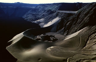
Geological Summary. Located at the SW tip of the J-shaped Isabela Island, Cerro Azul contains a steep-walled 4 x 5 km nested summit caldera complex that is one of the smallest diameter, but at 650 m one of the deepest in the Galápagos Islands. The shield volcano is the second highest of the archipelago. A conspicuous bench occupies the SW and west sides of the caldera, which formed during several episodes of collapse. Youthful lava flows cover much of the caldera floor, which has also contained ephemeral lakes. A prominent tuff cone located at the ENE side of the caldera is evidence of episodic hydrovolcanism. Numerous spatter cones dot the western flanks. Fresh-looking lava flows, many erupted from circumferential fissures, descend the NE and NW flanks. Historical eruptions date back only to 1932, but Cerro Azul has been one of the most active Galápagos volcanoes since that time. Solfataric activity continues within the caldera.
Information Contacts: H. Snell, P. Ramón, and H. Hoeck, CDRS, Galápagos.