Report on Lateiki (Tonga) — July 1979
Scientific Event Alert Network Bulletin, vol. 4, no. 7 (July 1979)
Managing Editor: David Squires.
Lateiki (Tonga) New island grows to 15 m high in mid-July
Please cite this report as:
Global Volcanism Program, 1979. Report on Lateiki (Tonga) (Squires, D., ed.). Scientific Event Alert Network Bulletin, 4:7. Smithsonian Institution. https://doi.org/10.5479/si.GVP.SEAN197907-243070
Lateiki
Tonga
19.18°S, 174.87°W; summit elev. 43 m
All times are local (unless otherwise noted)
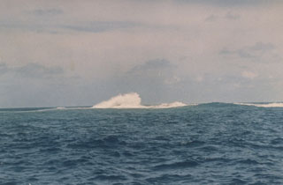
Geologists aboard the RV Bulikula inspected the volcanoes along the Tonga Arc between 3 and 21 July. A new island, named Late Iki, had formed above Metis Shoal at 19.18°S, 174.85°W, site of strong activity in June. The new island, comprised of tephra ranging in size from ash to large bombs, was ~300 m long, 120 m wide, and 15 m high in mid-July. Emission of hot ash continued from the E end of the island.
Short-lived islands were also formed over Metis Shoal during the eruptions of 1858 and 1967-8. The position determined (by satellite navigation) for the new island is approximately 1 km E of the one formed in 1967-68 (Melson and others, 1970). That island, estimated to have been 700 x 100 m and 15 m high, was eroded away within a month of the eruption's end.
No new pumice was being ejected by any of the volcanoes along the Tonga Arc.
Reference. Melson, W., Jarosewich, E., and Lundquist, C., 1970, Volcanic eruption at Metis Shoal, Tonga, 1967-1968, description and petrology: Smithsonian Contributions to the Earth Sciences, no. 4, 18 p.
Geological Summary. Lateiki, previously known as Metis Shoal, is a submarine volcano midway between the islands of Kao and Late that has produced a series of ephemeral islands since the first confirmed activity in the mid-19th century. An island, perhaps not in eruption, was reported in 1781 and subsequently eroded away. During periods of inactivity following 20th-century eruptions, waves have been observed to break on rocky reefs or sandy banks with depths of 10 m or less. Dacitic tuff cones formed during the eruptions in 1967 and 1979 were soon eroded beneath the ocean surface. An eruption in 1995 produced an island with a diameter of 280 m and a height of 43 m following growth of a lava dome above the surface.
Information Contacts: R. Richmond, Mineral Resources Dept., Fiji.