Report on St. Helens (United States) — March 1980

Scientific Event Alert Network Bulletin, vol. 5, no. 3 (March 1980)
Managing Editor: David Squires.
St. Helens (United States) Steam-and-ash explosions follow earthquake swarm
Please cite this report as:
Global Volcanism Program, 1980. Report on St. Helens (United States) (Squires, D., ed.). Scientific Event Alert Network Bulletin, 5:3. Smithsonian Institution. https://doi.org/10.5479/si.GVP.SEAN198003-321050
St. Helens
United States
46.2°N, 122.18°W; summit elev. 2549 m
All times are local (unless otherwise noted)
After [more than] a week of local seismicity, Mt. St. Helens began to erupt steam and ash on 27 March, the first eruption in the contiguous USA since the 1914-17 activity of Lassen Peak, California. Steam-and-ash explosions and earthquakes were continuing on 6 April, but no fresh magma had reached the surface.
Seismic activity [began to increase by 16 March and stronger activity was initiated] on 20 March at 1548 by a M [4.2] earthquake centered [about 4 km below] Mt. St. Helens. Events of magnitudes 3.5 on 22 March, 3.4 on 23 March, and 4.2, 3.4, and 3.4 on 24 March punctuated smaller events that were occurring every few minutes by the 24th at depths of less than 5 km. USGS and University of Washington seismologists installed an array of portable seismographs. USGS personnel who flew over the volcano on 24 March saw no new snow-free patches or fumaroles, but observed a number of snow avalanches triggered by earthquakes. Seismicity became more vigorous on 25 March, when eleven earthquakes of M 3.4-3.8 were recorded, and continued to increase the next day, when fourteen shocks of M 3.4-4.0 accompanied numerous smaller events that continued to occur.
At 1236 on 27 March, a loud noise heard more than 15 km from the summit heralded the initial steam-and-ash explosion. Ash emission continued until a M 4.5 earthquake was recorded at 1401. The explosion prompted the evacuation of about 360 persons from [near] Mt. St. Helens. A team of USGS volcanologists was sent to monitor the volcano. Helicopter reconnaissance revealed a new crater 60-75 m in diameter and about 50 m deep, located within the summit crater [that predated] the previous eruption, in 1857. A second explosion occurred at about 0300 the next morning, producing an ash-laden cloud that reached 2 km above the summit and a non-incandescent ash avalanche that flowed down the NW flank. Shortly thereafter, a steam plume rose to more than 3 km height. Aerial observers reported two nested arcuate fissures [first seen the afternoon of 27 March], one about 5 km long, the other about 1.5 km long, trending approximately E-W across the summit, S of and above the new crater.
By dawn on 28 March, pulses of dark, dense ash were rising to 3 km above the summit and some blocks were being ejected. Small mudflows moved in pulses and surges down the NE flank, reaching timberline by midafternoon. Occasional periods of rhythmic ash emission, lasting 45 minutes to l hour, occurred through the day, and more low-temperature ash avalanches traveled down the N and NE slopes. Many seismic events occurred, including one of M 4.2, concentrated in a zone about 2 km deep in the volcano's NW quadrant. That evening, the water level in Swift Lake Reservoir (figure 1) was lowered by at least 8 m as a precautionary measure, to accommodate any eruption-induced snowmelt runoff or mudflows.
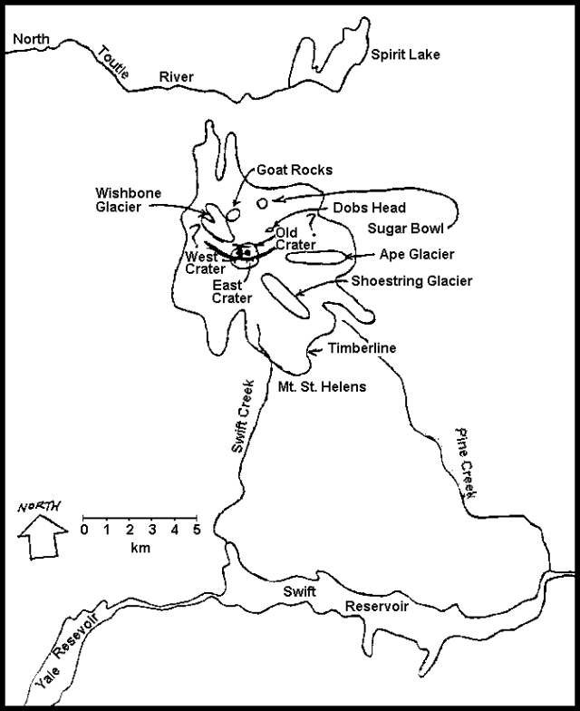 |
Figure 1. Sketch map of Mt. St. Helens. The positions and lengths of the arcuate summit fissures are approximate, as indicated by question marks at each end. The old summit crater is shown as larger than its actual diameter of about 0.5 km. The two active vents have coalesced at the surface, but maintain their separate identities. Courtesy of Robert Christiansen and Robert Tilling. |
A new 30- to 50-m-diameter crater, about 10 m from the one formed [on 27 March], was discovered during overflights 29 March. Blue flame was observed in the vents, at times flickering and jumping from one crater to the other. No strong ash pulses were reported between explosions on 28 March at 2300 and 30 March at 0410. During this period, seismic events appeared to migrate to the SSE along a 25 km-long linear trend, extending from 2 km depth in the volcano's NW quadrant to 15-20 km depth below Swift Reservoir, at the S foot of Mt. St. Helens. However, continuing analysis of the seismic data indicated that the apparent migration may be an artifact of data reduction and the crustal model used. Refinement of epicenter determinations is in progress.
Strong activity resumed on 30 March. At 0740 an anvil-shaped steam and ash cloud grew, producing ashfall as far away as Bend, Oregon, about 250 km to the S. The cloud could be seen on high-resolution NOAA weather satellite imagery, but the altitude of its top could not be estimated from the satellite data. An AP photo, probably of this explosion, clearly shows [an ash veil] moving most of the way down the SE flank. [D. Swanson notes that this phenomenon, described as a "sizeable ash avalanche" in the original report, was in fact only a veil of ash that moved slowly by gravity and deposited very little material.] Six more explosions projected ash to more than 1.5 km above the summit on the 30th.
A wind shift on 31 March sent ash from the continuing explosions W of the volcano onto more populated areas. Ashfall began about noon in the Kelso-Longview area (population 75,000), about 65 km W, leaving a thin layer of light-colored, abrasive material. Only minor venting occurred during the night of 31 March-1 April; three earthquakes of M 4.5-4.7 were recorded, with foci only 1 km beneath the summit, but the number of events was declining. Ash from a large explosion on 1 April was collected in Spokane, 500 km to the E.
Harmonic tremor was recorded for the first time from 1925 to 1930 on 1 April. This brief tremor episode was weak and poorly-defined, but vigorous, high-amplitude tremor, registered on nearly all seismic stations in W Washington, lasted from 1940 to 1955 on 2 April. Two bursts of harmonic tremor were recorded the next day, from 1840 to 1900 and 2100 to 2111; eleven individual earthquakes took place between the two tremor episodes on 3 April and a larger event occurred at 2115. Additional bursts of harmonic tremor occurred on 4 April from 0759 to 0826 and 1110 to 1142, and on 5 April between 1112 and 1130. Steam-and-ash emission continued intermittently through 6 April. Despite the bursts of tremor — evidence of magma movement within [or beneath] the volcano — there has been no evidence of juvenile material in any of the ejecta studied. To date, analysis of tilt and gravity data from the N flank has yielded no statistically significant deformation trends.
Geological Summary. Prior to 1980, Mount St. Helens was a conical volcano sometimes known as the Fujisan of America. During the 1980 eruption the upper 400 m of the summit was removed by slope failure, leaving a 2 x 3.5 km breached crater now partially filled by a lava dome. There have been nine major eruptive periods beginning about 40-50,000 years ago, and it has been the most active volcano in the Cascade Range during the Holocene. Prior to 2,200 years ago, tephra, lava domes, and pyroclastic flows were erupted, forming the older edifice, but few lava flows extended beyond the base of the volcano. The modern edifice consists of basaltic as well as andesitic and dacitic products from summit and flank vents. Eruptions in the 19th century originated from the Goat Rocks area on the N flank, and were witnessed by early settlers.
Information Contacts: D. Mullineaux, USGS, Denver CO; R. Christiansen, USGS, Menlo Park, CA; S. Malone, R. Crosson, E. Endo, Univ. of Washington; R. Tilling, USGS, Reston, VA.