Report on Chirinkotan (Russia) — June 1980
Scientific Event Alert Network Bulletin, vol. 5, no. 6 (June 1980)
Managing Editor: David Squires.
Chirinkotan (Russia) Lava flows and ash explosions
Please cite this report as:
Global Volcanism Program, 1980. Report on Chirinkotan (Russia) (Squires, D., ed.). Scientific Event Alert Network Bulletin, 5:6. Smithsonian Institution. https://doi.org/10.5479/si.GVP.SEAN198006-290260
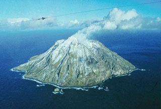
Chirinkotan
Russia
48.98°N, 153.48°E; summit elev. 724 m
All times are local (unless otherwise noted)
In April 1979, an eruption began from Chirinkotan volcano, which forms an isolated, uninhabited island about 3 km in diameter. Block lava flowed down the SSW flank in April and May. Ash explosions occurred regularly during the summer of 1979 and explosive activity increased in October. In January and April 1980, moderate explosions occurred 1-2 times per hour.
Geological Summary. The small, mostly unvegetated 3-km-wide island of Chirinkotan occupies the far end of an E-W volcanic chain that extends nearly 50 km W of the central part of the main Kuril Islands arc. It is the emergent summit of a volcano that rises 3000 m from the floor of the Kuril Basin. A small 1-km-wide caldera about 300-400 m deep is open to the SW. Lava flows from a cone within the breached crater reached the shore of the island. Historical eruptions have been recorded since the 18th century. Lava flows were observed by the English fur trader Captain Snow in the 1880s.
Information Contacts: G. Steinberg, Sakhalin Complex Institute.