Report on Kilauea (United States) — August 1981

Scientific Event Alert Network Bulletin, vol. 6, no. 8 (August 1981)
Managing Editor: Lindsay McClelland.
Kilauea (United States) More information on SW Rift intrusion
Please cite this report as:
Global Volcanism Program, 1981. Report on Kilauea (United States) (McClelland, L., ed.). Scientific Event Alert Network Bulletin, 6:8. Smithsonian Institution. https://doi.org/10.5479/si.GVP.SEAN198108-332010
Kilauea
United States
19.421°N, 155.287°W; summit elev. 1222 m
All times are local (unless otherwise noted)
An estimated 35 x 106 m3 of magma were intruded into Kīlauea's S summit region and SW rift 10-12 August, accompanied by seismicity, substantial summit deflation, and ground cracking in the SW summit area. Microearthquake activity in the S summit region began to increase about 0330 on 10 August, followed by the onset of rapid deflation about 1 hour later (figure 6). Earthquakes began to migrate away from the summit into the SW rift (figure 7) and by evening were concentrated about 17 km downrift, in approximately the same zone that had been seismically active during the later stages of the January-February intrusion. Seismic activity peaked during the evening of 10 August and gradually declined the next day. During the intrusion, seismic instruments detected thousands of small earthquakes, most shallower than 5 km, plus several magnitude 3.5-4.5 events that were felt near the volcano. Summit deflation continued, but at a slowly decreasing rate, until the late evening of 12 August, when inflation resumed. Weak harmonic tremor accompanied the slow summit reinflation. SW rift seismicity remained slightly above average in late August, but was continuing to decline.
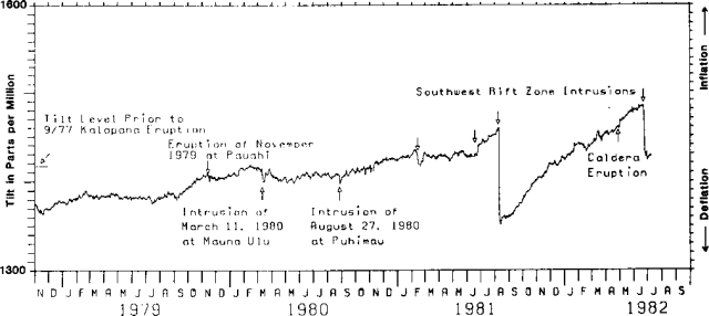 |
Figure 6. Summit tilt measured by HVO July 1978-June 1982. Tilt is recalculated to N60°W from E-W and N-S components. Each unit mark on the x axis represent 10 µrad of tilt (up = inflation). |
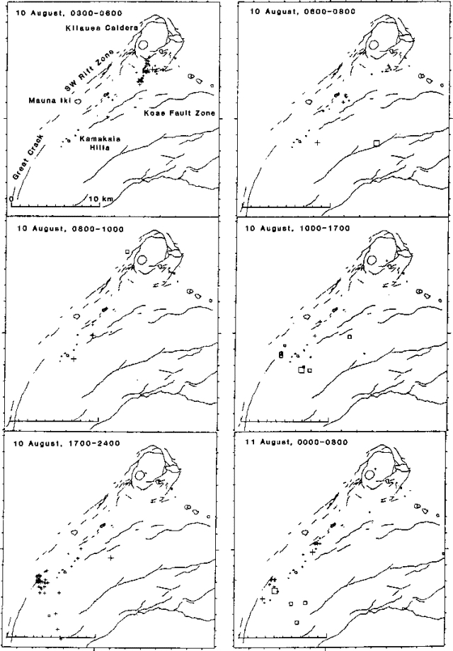 |
Figure 7. Locations of shallow (less than 7 km deep) summit and SW rift earthquakes recorded by HVO during various time intervals between 0330 on 10 August and 0800 on 11 August. Hypocenters less than 5 km deep are indicated by + signs; those deeper than 5 km by boxes. |
Geological Summary. Kilauea overlaps the E flank of the massive Mauna Loa shield volcano in the island of Hawaii. Eruptions are prominent in Polynesian legends; written documentation since 1820 records frequent summit and flank lava flow eruptions interspersed with periods of long-term lava lake activity at Halemaumau crater in the summit caldera until 1924. The 3 x 5 km caldera was formed in several stages about 1,500 years ago and during the 18th century; eruptions have also originated from the lengthy East and Southwest rift zones, which extend to the ocean in both directions. About 90% of the surface of the basaltic shield volcano is formed of lava flows less than about 1,100 years old; 70% of the surface is younger than 600 years. The long-term eruption from the East rift zone between 1983 and 2018 produced lava flows covering more than 100 km2, destroyed hundreds of houses, and added new coastline.
Information Contacts: Hawaiian Volcano Observatory, USGS.