Report on Teahitia (France) — April 1982

Scientific Event Alert Network Bulletin, vol. 7, no. 4 (April 1982)
Managing Editor: Lindsay McClelland.
Teahitia (France) Seismicity suggests first historical eruption
Please cite this report as:
Global Volcanism Program, 1982. Report on Teahitia (France) (McClelland, L., ed.). Scientific Event Alert Network Bulletin, 7:4. Smithsonian Institution. https://doi.org/10.5479/si.GVP.SEAN198204-333010
Teahitia
France
17.564°S, 148.821°W; summit elev. -1743 m
All times are local (unless otherwise noted)
On 14 March, the RSP began to record earthquakes in the vicinity of a seamount, with a summit at about 2 km below sea level, located about 3 km W of Rocard submarine volcano (17.640°S, 148.60°W) and 40 km NE of Tahiti's Taiarapu Peninsula. The increasing activity consisted only of low-magnitude earthquakes until 25 March, when the five Tahiti-Moorea seismic stations began to detect volcanic tremor of 5-10 Hz frequency (figure 1). The Laboratoire de Géophysique attributed the tremor to magma movement and submarine eruptions. Periods of tremor, of variable duration but nearly continuous on some days, accompanied the increasingly numerous discrete earthquakes. Tremor began to decline after 9 April and none has been recorded since the 18th. As of 23 April, weak earthquakes and episodic 1.5-2 Hz seismic noise continued. More than 10,000 individual earthquakes (ML > 0.9) were recorded during the swarm, the strongest of which had magnitudes of 3.5-4 (ML) and were felt on Tahiti.
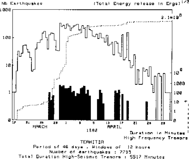 |
Figure 1. Seismicity near Teahitia during 17 March-30 April 1982. Number of recorded earthquakes at 12-hour intervals (solid line), duration of high-frequency tremor in minutes (bars), and cumulative seismic energy release (dashed line, log scale). Courtesy of J. Talandier. |
No volcanic activity had previously been known at the seamount, for which the name Teahitia has been proposed. The activity was similar to that of Mehetia (90 km ESE), March-December 1981.
Geological Summary. Teahitia is a submarine volcano in the Society Islands whose summit reaches to within ~1,700 m of the surface, 40 km NE of the SE tip of Tahiti Island. Several seismic swarms in the 1980s included volcanic tremor that may have resulted from submarine eruptions (Talandier and Opal, 1984). Rocks dredged in 1986 "exploded" when they reached the surface, suggesting recent lava extrusion that had not yet had time to equilibrate with pressure and temperature conditions on the submerged flanks of the edifice. Two hydrothermal fields each about 400 x 1,000 m exhibiting low-temperature hydrothermal venting were discovered on the flanks during submersible dives in 1986 and 1989.
Information Contacts: J.M. Talandier, Lab. de Géophysique, Tahiti.