Report on Galunggung (Indonesia) — July 1982
Scientific Event Alert Network Bulletin, vol. 7, no. 7 (July 1982)
Managing Editor: Lindsay McClelland.
Galunggung (Indonesia) Frequent eruptions continue
Please cite this report as:
Global Volcanism Program, 1982. Report on Galunggung (Indonesia) (McClelland, L., ed.). Scientific Event Alert Network Bulletin, 7:7. Smithsonian Institution. https://doi.org/10.5479/si.GVP.SEAN198207-263140
Galunggung
Indonesia
7.25°S, 108.058°E; summit elev. 2168 m
All times are local (unless otherwise noted)
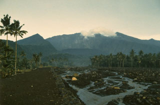
Intermittent eruptive activity continued to shower tephra on the area around the volcano and to send avalanches of pyroclastic material down river valleys draining SE.
Beginning at 1940 on 13 July and culminating with a fatal eruption on 16 July, explosions sent ash and lapilli as far as 40 km, destroying homes and refugee facilities. The first explosion was heard up to 50 km away, and rumbling sounds continued during the episode.
By 14 July at least 2 cm of ash had fallen in Tasikmalaya. The daytime sky was dark, the smell of sulfur noticeable. Explosions were heard as often as every 2 minutes, and the eruption column rose to 3-4 km. Six hot avalanches had traveled SE down the Cibanjaran and Cikunir Rivers, some as far as 2 km, by 15 July. At least 18 volcanic earthquakes had been recorded by the seismograph at Cikasasah, about 7 km SE of the volcano. When Galunggung erupted at 1500 on 16 July, at least 10 persons were killed, dozens injured, and many settlements destroyed. No information was available for 16-28 July.
Eruption plumes extending S and W were noted on GMS images 28, 29, 30, and 31 July, and 1 August. Images between 2000, 28 July and 0400, 29 July, showed a plume extending 800-900 km SSW from the volcano. Cloud-top temperatures of -40 to -45°C indicated an altitude of 10-10.5 km. This high plume was accompanied by a smaller, lower plume extending W. A new plume that had traveled WSW was seen on the image at 2300, 29 July. Indonesian radio reported that the 29 July eruption began at 1930 with thunderous explosions that continued for at least 3 hours and resulted in scorched forest areas. Tephra fell in Garut.
Satellite images recorded eruption plumes extending SW on 7, 9, 11, and 13 August. On 14 August a plume extended about 110 km S, then 110 km W. The Indonesian news agency Antara said the 9 August eruption began at 0935 with roars heard 50 km away and lasted over 3 hours. It produced "explosions of glowing magma," a 3-4-km-high eruption column, and tephra fall over a 40-km radius.
According to Antara, seismographs registered slight tremors of 2 mm amplitude on 13 August, followed by larger shocks of 8-12 mm amplitude at 1124. The eruption began at 1215 with rumbling and explosions that sent tephra and vapor to 2 km. At 1230 another tremor was recorded, accompanied by rumbling and tephra fall through a slight drizzle as far as Garut, where residents likened the sky to gloomy twilight. The eruption lasted until 1455.
Ash from the larger explosions has been reported as reaching Australia. Brilliant sunsets and twilight enhancement have been observed in Sydney.
Galunggung's explosive eruptions have forced the evacuation of 62,000 persons from the densely populated area close to the volcano. The horseshoe-shaped crater opens SE. Glowing avalanches have traveled 5 km, and mudflows generated by heavy rains 10 km down main river valleys draining in that direction. Houses, rice fields, fish ponds, and roads have been destroyed. The government of Indonesia asked UNDRO to coordinate international assistance and to help evaluate the hazards and relief needs.
Geological Summary. The forested slopes of Galunggung in western Java SE of Bandung are cut by a 2-km-wide collapse scarp open towards the ESE. The "Ten Thousand Hills of Tasikmalaya" dotting the plain below the volcano are debris-avalanche hummocks from the collapse about 4,200 years ago. An eruption in 1822 produced pyroclastic flows and lahars that killed over 4,000 people. A series of major explosive eruptions starting in April 1982 destroyed a number of villages, killed as many as 30 people, and forced over 60,000 to evacuate. Pyroclastic flows and heavy widespread ash caused significant damage. A large passenger jet that encountered the ash plume on 24 June lost power to all four engines but managed to land safely in Jakarta. The 1982 activity destroyed a 1918 dome and formed the Warirang crater, almost as wide as the valley, about 2 km down from the summit.
Information Contacts: M. Matson, S. Arnette, R. Borneman, D. Haller, and J. Hawkins, NOAA; D. Anderson, Singapore Airlines; Kompas and Sinar Harapan, Jakarta; Jakarta DRS; Antara News Agency, Jakarta; AFP; UNDRO News (July 1982).