Report on Okataina (New Zealand) — November 1982
Scientific Event Alert Network Bulletin, vol. 7, no. 11 (November 1982)
Managing Editor: Lindsay McClelland.
Okataina (New Zealand) Shallow earthquakes; no volcanic tremor
Please cite this report as:
Global Volcanism Program, 1982. Report on Okataina (New Zealand) (McClelland, L., ed.). Scientific Event Alert Network Bulletin, 7:11. Smithsonian Institution. https://doi.org/10.5479/si.GVP.SEAN198211-241050
Okataina
New Zealand
38.1569°S, 176.5069°E; summit elev. 1111 m
All times are local (unless otherwise noted)
A series of shallow earthquakes occurred 23-29 September a few kilometers SE of Haroharo Dome, in the Okataina Volcanic Center (figure 1). The main earthquake was at 1423 on 23 September. A foreshock preceded it by about 3 minutes, and three of the four large aftershocks followed at 1429, 1440, and 1452 (table 1). Many other aftershocks were recorded, the last at 0530 on 29 September.
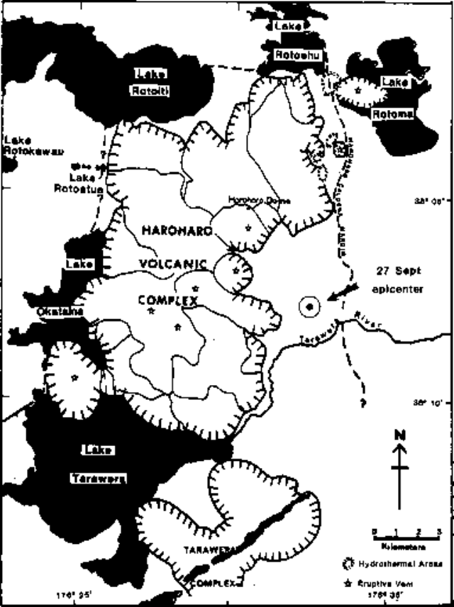 |
Figure 1. Map showing the Haroharo Volcanic Complex and part of the Tarawera Volcano in the Okataina Volcanic Center. From Cole and Nairn (1975). |
Table 1. Earthquakes of M > 2.5 recorded in the Okataina Volcanic Center during 23-29 September 1982.
| Date | Time | Magnitude |
| 23 Sep 1982 | 1420 | [3.3] |
| 23 Sep 1982 | 1423 | 4.1 |
| 23 Sep 1982 | 1429 | 2.6 |
| 23 Sep 1982 | 1440 | 3.2 |
| 23 Sep 1982 | 1452 | [2.9] |
| 27 Sep 1982 | 1806 | [2.7] |
I.A. Nairn, working on the N side of Tarawera Volcano (~11 km S of the epicenters) on 23 September, felt shocks and heard rockfalls nearby. He estimated the Modified Mercalli intensities of the foreshock and main shock as IV, and of the aftershocks at 1440 and 1452 at III-IV. He described the ground vibrations as low-frequency but relatively large-amplitude. Other nearby NZGS personnel noted the relatively low frequency of the felt shocks compared to typical local felt earthquakes. Observers noted that although they did not feel the shocks strongly outdoors, houses and vehicles resonated to large-amplitude vibrations. A small seiche was recorded on the N side of Lake Tarawera (7-8 km SW of the events). Three tilt networks around Tarawera Volcano showed no significant changes.
J.H. Latter placed the hypocenter for the 27 September event [at 38.129°S, 176.531°E, figure 1] about 5 km SE of Haroharo Dome at a depth of about 2 km. Nairn reported that this location coincides with a small area of surface faulting and geothermal activity. The 23 September earthquakes could not be located because of the lack of any nearby seismic records, but epicenters were estimated to be within 6 km of the 27 September event. Latter noted that the slow propagation of energy from the earthquakes and the low frequency of the felt shocks might suggest that they were "roof rock" events generated by activity in an underlying magma body. However, no volcanic tremor was detected during or after the earthquake sequence.
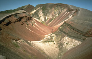
Although Haroharo has not been historically active, five eruptions in the last 10,000 years have been dated by 14C or tephrochronological methods. Very large explosive eruptions occurred roughly 2,050, 2,850, 5,050, and 7,050 years before the present (BP). Dome extrusion occurred at 2,450 years BP (± 400 years).
[Reference. Cole, J.W., and Nairn, I.A., 1975, Catalog of active volcanoes of the world, part XXII.]
Geological Summary. The massive, dominantly rhyolitic Okataina Volcanic Centre (OVC) is surrounded by extensive ignimbrite and pyroclastic sheets produced during multiple caldera-forming eruptions. Numerous lava domes and craters erupted from two subparallel NE-SW-trending vent lineations form the Haroharo and Tarawera volcanic complexes. Lava domes of the Haroharo complex, at the northern end of the OVC, occupy part of the 16 x 26 km Pleistocene Haroharo caldera, which formed incrementally between 300,000 and 50,000 years before present (BP). The oldest exposed rocks on the caldera floor are about 22,000 years old. The Tarawera complex at the southern end of OVC consists of 11 rhyolitic lava domes and associated lava flows. The oldest domes were formed as late as about 15,000 years BP, and the youngest were formed in the Kaharoa eruption about 800 years BP. The NE-SW Tarawera vent lineation extends from the two dacitic cones of Maungaongaonga and Mangakakaramea on the SW to Mount Edgecumbe on the NE. Construction of the Haroharo and Tarawera complexes impounded lakes Rotoiti, Totoehu, Okataina, and Tarawera against the outer margins of the Okataina ring structure. A major hydrothermal area is located at Waimangu; the world-renowned Pink and White Terrace siliceous sinter deposits were destroyed during the major basaltic explosive eruption of 1886.
Information Contacts: J. Latter, DSIR, Wellington; I. Nairn and B. Scott, NZGS, Rotorua; P. Otway, NZGS, Wairakei.