Report on Kilauea (United States) — January 1983

Scientific Event Alert Network Bulletin, vol. 8, no. 1 (January 1983)
Managing Editor: Lindsay McClelland.
Kilauea (United States) Major eruption in middle E Rift Zone
Please cite this report as:
Global Volcanism Program, 1983. Report on Kilauea (United States) (McClelland, L., ed.). Scientific Event Alert Network Bulletin, 8:1. Smithsonian Institution. https://doi.org/10.5479/si.GVP.SEAN198301-332010
Kilauea
United States
19.421°N, 155.287°W; summit elev. 1222 m
All times are local (unless otherwise noted)
[Much of the information in 07:12 was repeated or updated in 08:01. We have therefore combined the reports.] "An eruption in the E rift zone began at 0031 on 3 January. The outbreak began at Napau Crater (figure 15), 14 km SE of the caldera rim, and extended progressively NE. By 0740, the line of eruptive fissures was 6 km long and its E end was about 0.7 km SE of Pu'u Kahaualea. Fountaining and production of SE-moving lava flows of local extent continued until 1002. After a 4.5 hour pause, the eruption resumed at 1425 along a 100-m fissure at the NE (downrift) end of the vent system (about 600 m S of Pu'u Kahaualea). This eruption lasted until 1535. During this first day's activity, fountains up to 80 m high produced an estimated 2-3 x 10⁶ m3 of lava.
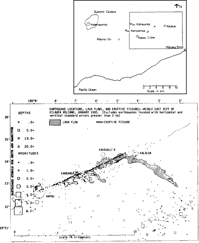 |
Figure 15. Index map of the summit region and E rift (top) and map of earthquake locations, lava flows, and eruptive fissures on the middle E rift zone, January 1983 (bottom). |
"The volcano remained quiet for nearly 2 days. Eruptive activity resumed at 1123 on 5 January and continued with only brief interruptions until 2049 on 6 January. The eruptive activity jumped from one segment to another of a kilometer-long section of the vent system S of Pu'u Kahaualea (including, at its E end, the easternmost vent of 3 January). A large amount of the lava poured into an open crack, parallel to the eruptive vents and about 0.1 km SE of their E ends. The crack was along a bounding fault at the NW edge of a prominent older graben. Minor aditional fountaining and flow production also occurred at, and within 1.5 km SW of, Pu'u Kamoamoa, along vents established on 3 January.
"On the morning of 7 January the main eruptive center shifted temporarily still farther NE to a 1 km-long line of vents approximately 1.4 km ESE of Pu'u Kahaualea. After a brief introductory emission from 0957-0959, these vents erupted strongly from 1030-1557 on 7 January. During this period, they produced the highest fountains of the eruption; maximum sustained fountain heights of 80-100 m were estimated, with bursts sending fragmented spatter higher. This episode also fed a lava flow nearly 6 km long that extended E toward Kalalua then turned SE toward the coast. The flow, with an estimated volume of about 4 x 10⁶ m3, converted to aa as its front passed near Kalalua and stopped nearly 5 km from the coast. A second eruption from the same vents, from 1625 on 7 January to 0430 on 8 January, produced a smaller lava flow that overrode the near end of the first flow from the vents E of Pu'u Kahaualea.
"Seven episodes of lava production ranging in duration from 8 minutes to 11 hours occurred 8-15 January from a group of vents S and SW of Pu'u Kahaualea that were active 5-6 January. The first and briefest of these (from 1446-1454 on 8 January) was from the E end of this group of vents. The remainder erupted from the W half of the kilometer-long line. Six of the seven extrusive episodes occurred 8-11 January, the latest on 15 January. One additional extrusion occurred 8 days later, during the evening of 23 January, when approximately 7000-8000 m3 of lava were erupted about 0.25 km E of Pu'u Kamoamoa following a magnitude 4.2 earthquake on the S flank.
"New lava covered an area of approximately 4.4 x 10⁶ m3. The erupted volume is estimated to be on the order of 10 x 106 m3. Repeated measurements indicate an eruption temperature of about 1,135°C. The basalt is slightly porphyritic with scattered small plagioclase and olivine phenocrysts.
"Strong emission of sulfur-rich gases has continued since the beginning of the eruption; widespread dispersal of the gases had caused vegetation damage over large areas of E Hawaii. Between extrusive events (and continuing at the time of this report) some vents S of Pu'u Kahaualea remained at temperatures of about 1,070°C and burning gases were visible at night. These vents periodically emit spatter composed, at least in part, of incandescent and partly melted fragments eroded from the vent walls.
Seismicity. "In the weeks prior to the eruption seismographs recorded increasing rates of microearthquakes in the E rift zone. At 0030 on 2 January the seismicity developed into a swarm of small shallow (depth < 5 km) earthquakes (figure 16) and weak harmonic tremor. The swarm started in the upper E rift near Mauna Ulu, increased in the early hours and migrated downrift about 9 km to Napau Crater. Tiny earthquakes were recorded at a rate of 3-5/minute; seismic intensity peaked between 0040 and 0110, when several earthquakes, magnitude 2.5 to 3.0, were felt in the Hawaii Volcanoes National Park area. From 0300 to 1300 2 January, the seismic zone spread farther downrift to beyond Pu'u Kamoamoa (figure 17). From then until the eruptive outbreak, small earthquakes accompanied by harmonic tremor occurred at a nearly constant rate, mainly along a zone between Napau Crater and Pu'u Kamoamoa. When the eruption was sighted at Napau Crater by a ground crew at 0031 on 3 January, [instruments] started to record increasing harmonic tremor amplitudes and constant summit deflation.
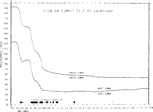 |
Figure 16. N-S and E-W components of summit tilt measured at Uwekahuna Vault, NW caldera rim, January 1983. Periods of lava production are also shown. |
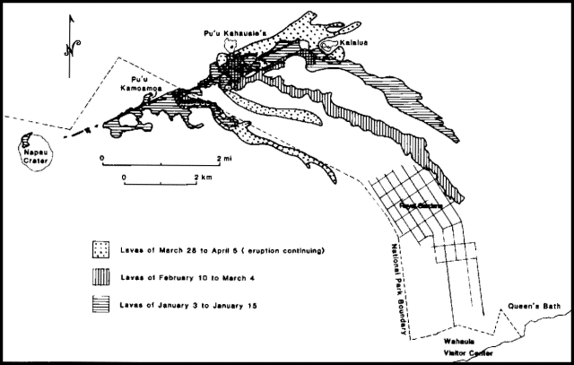 |
Figure 17. Map of 1983 lava flows and eruptive fissures on the middle E rift zone for the periods 3-15 January (horizontal lines), 10 February-4 March (vertical lines), and 28 March-5 April (dotted pattern). |
From 3 through 6 January the shallow earthquakes were broadly distributed from near Napau to beyond Pu'u Kahaualea. Harmonic tremor, although continuous, waxed and waned in consonance with the production of lava. In the early morning hours of 7 January, however, the shallow earthquake activity precursory to the opening of the vents E of Pu'u Kahaualea was concentrated in a zone that extended approximately from Pu'u Kahaualea to about 2 km downrift from Kalalua. Since then earthquake activity in the eruptive zone has been relatively low (figure 18). At the end of January, seismographs were still registering a moderate level of harmonic tremor originating from a source in the vicinity of the eruptive vents extending 2 or 3 km E of Pu'u Kamoamoa to near Pu'u Kahaualea.
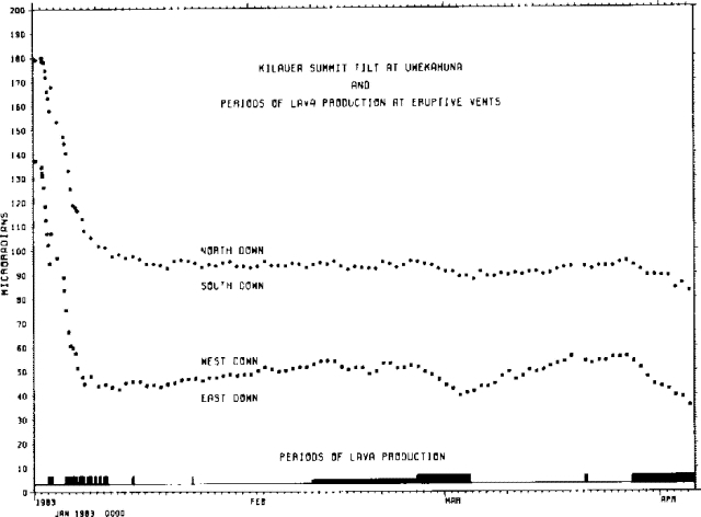 |
Figure 18. N-S and E-W components of summit tilt measured at Uwekahuna Vault, NW caldera rim, January-April 1983. Periods of lava production are also shown. |
"Throughout the month thousands of shallow earthquakes were generated in the eruption zone. Of these, nearly 500, most from depths of less than 4 km and magnitude 0.5-4.0, were processed for size and location. The vast majority of the earthquakes probably record emplacement and establishment of the feeder dike system, a process that was completed on the morning of 7 January.
"Deeper earthquakes (5 to 13 km) that occurred throughout the month beneath the S flank were more or less representative of adjustment of the S flank that continues over the long term. However, a somewhat elevationated frequency of occurrence of S flank earthquakes in the early part of the month was probably a direct response to increased stress from the magmatic activity in the rift zone.
Deformation. "Tiltmeters in the Uwekahuna Vault recorded a summit collapase of about 125 µrad (figure 16), which represents an estimated volume loss of 50 x 106 m3 from the summit region. Broken only by temporary inflation during the non-eruptive interval between 3 and 5 January, almost all of the summit deflation occurred at a high rate from early on 2 January to early on 8 January. The summit subsidence and the period of intense shallow seismic activity were coincident. Approximately 3/4 of the volume of extruded lava was erupted during the same period. Minor, very slow deflation of the summit continued until about 18 January. Gradual recovery of about 4 µrad of tilt occurred during the remainder of the month.
"Geo-electric and recorded tilt changes in the E rift zone on 3 January strongly suggest that magma was intruding the rift as far down as Kalalua at that time. However, observations of ground cracking, tilt measurements, and electronic distance measurements show that major extension (> 2 m) perpendicular to the rift zone occurred N and NE of Kalalua late on 6 January and during 7 January. An electronically measured line across the eruptive fissures S of Pu'u Kahaualea, initiated on 19 January, has shown a steady extension averaging 7 mm/day during the last part of January.
Summary. "Although no major lava production has occurred since 15 January (a minor extrusion occurred on 23 January), the continuing steady harmonic tremor, voluminous gas emission, occurrence of incandescent and flaming vents, and extension across the recently active eruptive fissure S of Pu'u Kahaualea indicate that the magmatic activity related to the January 1983 eruption has not yet ended."
Geological Summary. Kilauea overlaps the E flank of the massive Mauna Loa shield volcano in the island of Hawaii. Eruptions are prominent in Polynesian legends; written documentation since 1820 records frequent summit and flank lava flow eruptions interspersed with periods of long-term lava lake activity at Halemaumau crater in the summit caldera until 1924. The 3 x 5 km caldera was formed in several stages about 1,500 years ago and during the 18th century; eruptions have also originated from the lengthy East and Southwest rift zones, which extend to the ocean in both directions. About 90% of the surface of the basaltic shield volcano is formed of lava flows less than about 1,100 years old; 70% of the surface is younger than 600 years. The long-term eruption from the East rift zone between 1983 and 2018 produced lava flows covering more than 100 km2, destroyed hundreds of houses, and added new coastline.
Information Contacts: E. Wolfe, A. Okamura, R. Koyanagi, HVO.