Report on Michoacan-Guanajuato (Mexico) — April 1983
Scientific Event Alert Network Bulletin, vol. 8, no. 4 (April 1983)
Managing Editor: Lindsay McClelland.
Michoacan-Guanajuato (Mexico) Fumaroles emit acid gases
Please cite this report as:
Global Volcanism Program, 1983. Report on Michoacan-Guanajuato (Mexico) (McClelland, L., ed.). Scientific Event Alert Network Bulletin, 8:4. Smithsonian Institution. https://doi.org/10.5479/si.GVP.SEAN198304-341060
Michoacan-Guanajuato
Mexico
19.85°N, 101.75°W; summit elev. 3860 m
All times are local (unless otherwise noted)
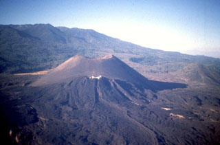
"Fumaroles at several localities were emitting small amounts of acid gases but there was no visible plume at the summit or elsewhere when visited 28 April-1 May. Temperatures were mostly less than 150°C but some were much hotter, over 400°C."
Geological Summary. The widespread Michoacán-Guanajuato volcanic field contains over 1,400 vents, including the historically active cinder cones of Parícutin and Jorullo, covering a 200 x 250 km wide area of Michoacán and Guanajuato states in west-central México. Cinder cones are the predominant volcanic form, but small shield volcanoes, lava domes, maars and tuff rings (many in the Valle de Santiago area), and coneless lava flows are also present. The volcanoes with shield-type morphologies are mostly Pleistocene in age, although the Michoacán-Guanajuato centers have higher slope angles and smaller basal diameters. Jorullo, which was constructed in the 18th century, and Parícutin, which grew above a former cornfield during 1943-52, are the two best known volcanic features scattered throughout the field.
Information Contacts: R. Stoiber, L. Benton, C. Connor, D. Douglass, D. Shumway, and J. Swartz, Dartmouth College.