Report on Tongariro (New Zealand) — May 1983
Scientific Event Alert Network Bulletin, vol. 8, no. 5 (May 1983)
Managing Editor: Lindsay McClelland.
Tongariro (New Zealand) Earthquake swarms
Please cite this report as:
Global Volcanism Program, 1983. Report on Tongariro (New Zealand) (McClelland, L., ed.). Scientific Event Alert Network Bulletin, 8:5. Smithsonian Institution. https://doi.org/10.5479/si.GVP.SEAN198305-241080
Tongariro
New Zealand
39.157°S, 175.632°E; summit elev. 1978 m
All times are local (unless otherwise noted)
The following seismic data, from Balsillie and Latter (1985), replaces the first two sentences of the original report, which dealt only with 16 May seismicity. [Three swarms of A-type earthquakes were recorded during the first half of 1983. The first and smallest included 14 events to M 1.8 on 16-19 February. About 20 A-type and 4 B-type (including the largest, at magnitude 2.4) shocks occurred 1-7 April, plus two episodes of possible volcanic tremor (for 7 hours on 2 April and 10 hours on 4 April). The largest swarm began gradually on 7 May, peaked 14-16 May (maximum magnitude 2.1), and ended about 29 May, accompanied by 4 more episodes of possible volcanic tremor. During the strongest activity, 15-20 events of M >1.0 were recorded daily.]
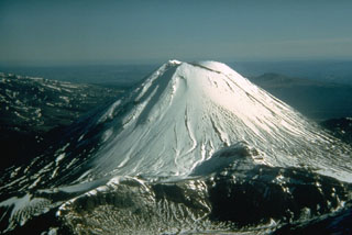
On 10 May, NZGS personnel measured temperatures of the hot gases issuing from the crater bottom. Rockfalls from the overhanging E crater wall and growing talus fans had reduced the degassing area. Temperatures of 320-350°C were measured 1-2 m from the accessible edge of the hot area. These reflected a nearly steady decrease: 620° (1 July 1978), 520° (24 February 1979), 478° (25 June 1981), 418° (21 January 1982), 458° (10 June 1982), [349° (4 May 1983) and 105° (7 February 1985]. Ngāuruhoe last erupted 12-23 February 1975, when strong explosive activity sent eruption plumes to 10 km and pyroclastic flows moved down the flanks (Nairn and Self, 1978).
Reference. Nairn, I.A., and Self, S., 1978, Explosive eruptions and pyroclastic avalanches from Ngāuruhoe in February 1975: JVGR, v. 3, p. 39-60.
Further Reference. Balsillie, F.H., and Latter, J.H., 1985, Volcano-seismic activity at Ngāuruhoe during 1983: New Zealand Volcanological Record, no. 13, p. 66-71.
Geological Summary. Tongariro is a large volcanic massif, located immediately NE of Ruapehu volcano, that is composed of more than a dozen composite cones constructed over a period of 275,000 years. Vents along a NE-trending zone extending from Saddle Cone (below Ruapehu) to Te Maari crater (including vents at the present-day location of Ngauruhoe) were active during several hundred years around 10,000 years ago, producing the largest known eruptions at the Tongariro complex during the Holocene. North Crater stratovolcano is truncated by a broad, shallow crater filled by a solidified lava lake that is cut on the NW side by a small explosion crater. The youngest cone, Ngauruhoe, is also the highest peak.
Information Contacts: W. Giggenbach, DSIR, Wellington.