Report on Grimsvotn (Iceland) — May 1983
Scientific Event Alert Network Bulletin, vol. 8, no. 5 (May 1983)
Managing Editor: Lindsay McClelland.
Grimsvotn (Iceland) Subglacial activity ejects large vapor plumes; small island in meltwater lake; minor ashfall; no jökulhlaups
Please cite this report as:
Global Volcanism Program, 1983. Report on Grimsvotn (Iceland) (McClelland, L., ed.). Scientific Event Alert Network Bulletin, 8:5. Smithsonian Institution. https://doi.org/10.5479/si.GVP.SEAN198305-373010
Grimsvotn
Iceland
64.416°N, 17.316°W; summit elev. 1719 m
All times are local (unless otherwise noted)
"A subglacial volcanic eruption started in Grímsvötn below the W part of the ice cap Vatnajökull on 28 or 29 May. The central part of the Grímsvötn area is a caldera of about 35 km2, one of the most active volcanic and geothermal areas in Iceland.
"Melting of ice due to intense geothermal activity and continuous inflow of ice causes a gradual buildup of meltwater below the 200-m-thick floating ice shelf in the caldera. This buildup culminates in a jökulhlaup (glacier burst) when the level of the lake reaches a certain threshold value. The water drains in a catastrophic flood beneath the ice, 50-60 km into the rivers on the Skeidarársandur outwash plain S of the ice cap. The jökulhlaups last about 3 weeks and occur about once to twice every decade, the last one in January-February 1982.
"The last definite volcanic eruption in the caldera was in 1934 but small eruptions may have occurred since without being noticed due to the remoteness of the area. In most cases known previous eruptions have been accompanied by jökulhlaups. The new eruption was preceded by an intense earthquake swarm that began at about 0400 on 28 May. The largest earthquakes were in the magnitude range 3-3.5. Earthquake activity declined at about 1000 and soon after that bursts of volcanic tremor began to appear on the seismograms. The tremor amplitude increased at about 1500 and intense bursts of tremor were recorded for the rest of that day and the next day. During the following days the tremor gradually decreased in amplitude.
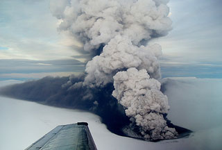
"The first definite observation of the eruption was on 29 May at 1030 from an aircraft, diverted to fly over Grímsvötn by request from seismologists. At that time the eruption had broken through the ice and produced a 5-km-long very thin ash fan downwind on the ice cap S of Grímsvötn. Steam clouds were observed in the direction of Grímsvötn on 28 May at about 2115. Weather satellite images on 29 May show a long narrow cirrus cloud that almost certainly originated at Grímsvötn during the morning of 29 May, at 0300 at the latest.
"When the eruption was observed on 29 May an opening had formed in the ice shelf inside the caldera near the SW wall. This lake was oval-shaped, about 300 m in diameter, and during 29 May covered by raft ice from the overhanging caldera wall. Explosions were observed in the lake at varying time intervals. The highest explosions reached about 50 m but the accompanying steam columns reached 1-2 km. During the next few days, weather conditions prevented direct observations except the height of the steam column. On 30 May, a maximum height of 6,000-7,000 m was observed, on the 31st 7,000-8,000 m, and on 1 June about 5,000 m. The steam column was intermittent, never continuous. After that, no activity has been observed, but on 5 June a small island was observed in the steaming lake.
"No change has been observed in the rivers that drain the glacier. At this time, it is not known whether the eruption has affected the lake level within the Grímsvötn caldera."
Further Reference. Einarsson, P., and Brandsdóttir, B., 1984, Seismic activity preceding and during the 1983 volcanic eruption in Grímsvötn, Iceland: Jökull, v. 34, p. 13-23.
Grönvold, K., and Jóhannesson, H., 1984, Eruption in Grímsvötn 1983; course of events and chemical studies of the tephra: Jökull, v. 34, p. 1-11.
Geological Summary. Grímsvötn, Iceland's most frequently active volcano in recent history, lies largely beneath the vast Vatnajökull icecap. The caldera lake is covered by a 200-m-thick ice shelf, and only the southern rim of the 6 x 8 km caldera is exposed. The geothermal area in the caldera causes frequent jökulhlaups (glacier outburst floods) when melting raises the water level high enough to lift its ice dam. Long NE-SW-trending fissure systems extend from the central volcano. The most prominent of these is the noted Laki (Skaftar) fissure, which extends to the SW and produced the world's largest known historical lava flow in 1783. The 15 km3 basaltic Laki lavas were erupted over 7 months from a 27-km-long fissure system. Extensive crop damage and livestock losses caused a severe famine that resulted in the loss of one-fifth of the population of Iceland.
Information Contacts: K. Grönvold, NVI; P. Einarsson and H. Björnsson, Univ. of Iceland.