Report on Colo (Indonesia) — July 1983
Scientific Event Alert Network Bulletin, vol. 8, no. 7 (July 1983)
Managing Editor: Lindsay McClelland.
Colo (Indonesia) Pyroclastic flows devastate island; clouds to stratosphere; evacuations prevent large death toll
Please cite this report as:
Global Volcanism Program, 1983. Report on Colo (Indonesia) (McClelland, L., ed.). Scientific Event Alert Network Bulletin, 8:7. Smithsonian Institution. https://doi.org/10.5479/si.GVP.SEAN198307-266010
Colo
Indonesia
0.162°S, 121.601°E; summit elev. 404 m
All times are local (unless otherwise noted)
An explosive eruption produced pyroclastic flows that destroyed most homes, vegetation, and animal life on 40 km2 Una Una Island and probably injected tephra into the stratosphere. Initial activity prompted evacuation of everyone on the island before the devastating explosions.
The eruption was preceded by seismicity that increased from 9-11 felt events/day on 8 July to 30-40/day on 15 July. The number of recorded events was 33 on 14 July, increasing the following days to 49, 53, and 73 then to an average of more than 90/day 18-21 July. The strongest earthquake was felt 400 km away on 18 July. That morning, a 1-km column of ash and incandescent material was ejected. AFP reported that a strong explosion occurred 19 July, and thick gray clouds containing incandescent tephra were visible from Ampana, more than 100 km to the S, the next day.
By the 20th, almost all houses and buildings in the eight villages near the volcano had been destroyed and nearly half of the residents of the island had been evacuated. All had left by the time of a major explosion on 21 July at 1623 that subjected 80% of the island to temperatures of up to 200°C. Tephra as large as 5-10 cm in diameter fell near a VSI observation vessel and the monitoring team reported flames on parts of the island. A government geologist estimated that all 700,000 coconut trees and all livestock on the island must have been burned, probably by pyroclastic flows. Ash darkened much of the region. People in Falu, 250 km away, were forced to protect themselves from ashfall until late 23 July. A VSI field party arriving on the island 22 July at 0100 felt ten earthquakes during their 15-hour stay and observed a 1.5-km eruption column at 1649.
On 23 July at 2055, a British Airways jet (en route from Singapore to Perth) flying at 10.6 km altitude encountered an eruption cloud at 1.4°S, 120.71°E, about 150 km S of Una Una (figure 1). Pilots noted a volcanic smell, lack of visibility, and St. Elmo's Fire around the windshield. The aircraft returned immediately to Singapore and suffered no damage. On 24 July at 1930, a satellite image showed a cloud about 120 km wide, extending about 600 km S from Una Una. Earlier in the eruption, weather clouds had obscured the Una Una area. Press reports quoted a local government official who said that 80% of the island was covered by volcanic clouds on 24 July, burning vegetation and destroying trees. On 26 July at 0000, the Japanese GMS satellite showed what appeared to be a dense eruption column rising from the island. On the next image, two hours later, a fan-shaped plume was visible, probably in or near the stratosphere. High-altitude material was blowing SW and W, while low and mid-level debris was drifting slowly S to SSE.
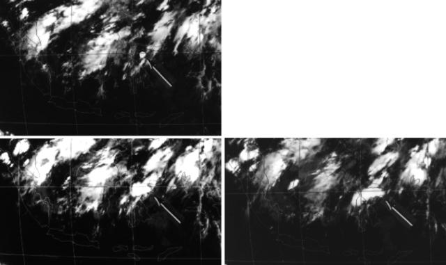 |
Figure 1. Portions of three GMS images showing the expansion of the cloud produced by the explosions of 23 July 1983, when hot avalanches devastated Una Una island shortly after residents had been evacuated. An arrow points to the eruption plume on each image. Land areas are outlined, from Sumatra and the Malay Peninsula at left to Timor and Halmahera at right. Image scans began at 1631 (upper left), 1831 (lower left), and 1931 (lower right), with "x" marking position of aircraft 84 minutes later. Courtesy of Yosihiro Sawada. [Originally from 8:9.] |
On 28 July at 0200 the GMS satellite showed a small plume over the island. By 0500 a plume about 60 km wide extended about 200 km WSW from the volcano. The plume appeared denser at 0800 and by 1100 vigorous activity fed a cloud that reached 118 E and at least 13.5 km altitude. At 1400 the plume stretched about 500 km to the WSW and was very dense within 250 km of the volcano. Temperatures and wind directions at the tropopause (15 km altitude) were consistent with the plume's direction of movement and coldest temperature (-76°C) from a NOAA 7 image at 1430 (figure 2). By the next image, at 2000, the plume had dissipated. The GMS satellite showed the beginning of another eruptive episode on 30 July at 1630. At 2000, a NOAA 7 image contained a WSW-drifting plume, similar to the one on 28 July but not as spectacular. Feeding of this plume was continuing at 2300; it drifted SW, then W toward Sulawesi. It extended from the volcano about 200 km to 1.5°S, 119.5°E on 31 July at 0200, but was dissipating three hours later. At 2000 an image showed what appeared to be an eruption column, but little activity was visible three hours later.
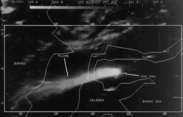 |
Figure 2. NOAA 7 thermal infrared satellite image showing an 800-km-long eruption plume from Una Una 28 July at 1430. White areas are coldest (see gray scale at top of figure). The coldest part of the plume had a temperature of -76°C, indicating that it had penetrated the stratosphere. Courtesy of Michael Matson. |
Another explosive episode first appeared on the imagery 2 August at 0500. Before activity ended at 1700, a plume had moved about 200 km to theSW and reached roughly 9-12 km altitude. A dense eruption column appeared over the island 3 August at 0000 and extended roughly 120 km to the W and SW two hours later. The plume was relatively diffuse and appeared to have reached only the mid-troposphere. Satellite images indicated that another explosion started 4 August at about 1000, feeding a plume that moved about 350 km to the NNW. The different direction of drift was the result of a weather change; this plume probably remained in the troposphere. AFP reported an eruption on 9 August at 0835 that ejected a gray plume to 3 km. No activity was evident on satellite images until 12 August at 0130, when a plume was observed that was not visible two hours earlier. At 0300, NOAA 7 data showed a dense plume, similar to that of 28 July, extending about 300 km SW to central Sulawesi.
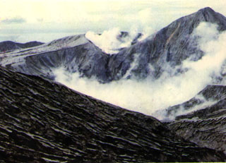
Geological Summary. Colo volcano forms the isolated small island of Una Una in the middle of the Gulf of Tomini in northern Sulawesi. The broad, low volcano contains a 2-km-wide caldera with a small central cone. Three eruptions have been recorded since the late 1800's, but two of those caused widespread damage over the island. The last eruption, in 1983, produced pyroclastic flows that swept over most of the island shortly after all residents had been evacuated.
Information Contacts: A. Sudradjat, VSI; N. Banks, HVO; M. Matson, J. Hawkins, O. Karst, and S. Kusselson, NOAA/NESDIS; AFP; Antara News Agency, Jakarta; UPI.