Report on St. Helens (United States) — July 1983

Scientific Event Alert Network Bulletin, vol. 8, no. 7 (July 1983)
Managing Editor: Lindsay McClelland.
St. Helens (United States) Lava dome growth continues; plumes emitted
Please cite this report as:
Global Volcanism Program, 1983. Report on St. Helens (United States) (McClelland, L., ed.). Scientific Event Alert Network Bulletin, 8:7. Smithsonian Institution. https://doi.org/10.5479/si.GVP.SEAN198307-321050
St. Helens
United States
46.2°N, 122.18°W; summit elev. 2549 m
All times are local (unless otherwise noted)
Growth of the composite lava dome continued through early August (figure 24). Net advance of the active lobe was reduced to roughly 10-20 m in July by frequent rockfalls from its front, but one area on the lobe thickened 11 m during the month. Deformation measurements showed continuing intrusive activity. The highest rates of expansion were on the NE side of the dome, where outward movement averaged 60-70 cm/day, although fluctuations by a factor of two to three were observed for periods lasting a maximum of 3-4 days. The station on the SE side of the dome typically moved outward 1-2 cm/day but this rate sometimes briefly increased to several centimeters per day. A short-term acceleration of endogenous growth in mid-July was accompanied by a slowing in extrusion of the new lobe.
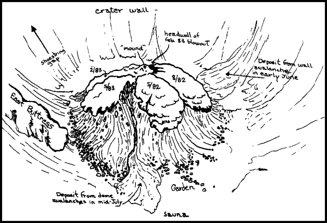 |
Figure 24. Sketch by Bobbie Myers of the Mt. St. Helens composite lava dome, viewed from the N on 17 July 1983. Recent lobes are dated. |
Two vents on the summit of the dome were the sources of three to six small steam-and-ash explosions per day in July and early August. Plumes from most of the explosions barely cleared the crater rim, typically causing a fallout of fine ash within the crater, but little or none outside. A larger explosion in late July produced ballistic fragments 1 cm in diameter and a plume with considerable lightning. A steam and ash plume reached 4.5 km altitude 4 August and another rose to 3.5 km on 6 August.
The average rate of SO2 emission in July was 120 ± 80 t/d. Measurements 4, 5, 6, and 10 July yielded mean values of 85 ± 15 t/d, then the emission rate increased 15, 17, and 21 July to 225 ± 70 t/d before dropping back to 80 ± 50 t/d 22-29 July and roughly 50 t/d 1-9 August. Mid-month increases in endogenous-dome growth and seismicity were also noted (see first and last paragraphs of this report).
Measurements were made of the SO2 content of two plumes produced by vapor-and-ash ejections. On 1 August, data collection began with the onset of the explosion and continued for 30 minutes after plume ejection ended. No change in the SO2 emission rate (55 ± 5 t/d) was observed. Two measurements before a plume ejection 9 August yielded rates of about 40 t/d. Values within the plume were initially 105 t/d before dropping gradually back to 40 t/d as it dissipated.
July seismic activity was similar to that of previous months. Vigorous surface activity was recorded, some of which was thought to be caused by avalanching from the crater walls on warm days. Several brief periods of increased seismicity were noted, and the largest, around the middle of the month, produced a noticeable step in the seismic energy release curve.
Geological Summary. Prior to 1980, Mount St. Helens was a conical volcano sometimes known as the Fujisan of America. During the 1980 eruption the upper 400 m of the summit was removed by slope failure, leaving a 2 x 3.5 km breached crater now partially filled by a lava dome. There have been nine major eruptive periods beginning about 40-50,000 years ago, and it has been the most active volcano in the Cascade Range during the Holocene. Prior to 2,200 years ago, tephra, lava domes, and pyroclastic flows were erupted, forming the older edifice, but few lava flows extended beyond the base of the volcano. The modern edifice consists of basaltic as well as andesitic and dacitic products from summit and flank vents. Eruptions in the 19th century originated from the Goat Rocks area on the N flank, and were witnessed by early settlers.
Information Contacts: D. Swanson, R. Symonds, E. Iwatsubo, B. Myers, USGS CVO, Vancouver, WA.