Report on St. Helens (United States) — June 1984

Scientific Event Alert Network Bulletin, vol. 9, no. 6 (June 1984)
Managing Editor: Lindsay McClelland.
St. Helens (United States) New lobe extruded into notch in dome's W flank
Please cite this report as:
Global Volcanism Program, 1984. Report on St. Helens (United States) (McClelland, L., ed.). Scientific Event Alert Network Bulletin, 9:6. Smithsonian Institution. https://doi.org/10.5479/si.GVP.SEAN198406-321050
St. Helens
United States
46.2°N, 122.18°W; summit elev. 2549 m
All times are local (unless otherwise noted)
A new lobe in the composite lava dome began to emerge in mid-June. Its location, on the W flank, was within the notch that was the source of explosions 14, 26, and 27 May, and 6 June as well as a similar event on 7 June. Growth of the W flank lobe had stopped by 1 July. Accelerating deformation on the dome's N side was measured in late June and early July, but rates of displacement began to decrease after several days and no lava reached the surface.
A small explosion occurred 7 June at 1720, when airline pilots observed an ash cloud that rose to about 9 km altitude. Increased water flow from the crater began at about 1740, and a mudflow about 3 m wide and 15 cm deep reached Spirit Lake at 1802.
Beginning 14-15 June, the number of earthquakes at the nearest crater seismometer (Yellow Rock) increased from about 20-30 to 50-60/day, and the number of surface (rockfall) events began to increase 16-17 June. The small new lobe was first seen during the afternoon of 17 June (by gas-monitoring aircraft pilot Allyn Merris), and was more clearly visible during an overflight at 2230 that night. The dome was photographed from the air 18 June (figure 25).
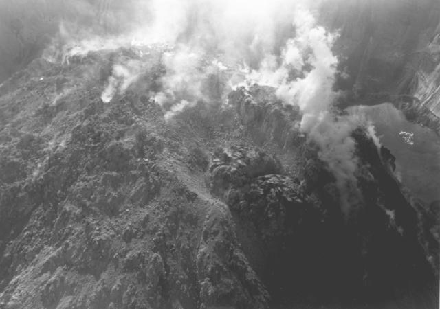 |
Figure 25. Photograph of the new lobe on the W side of the Mt. St. Helens composite dome taken on 18 June 1984, early in the extrusion episode. By 1 July, the lobe had overfilled the 50-m-wide notch. Photo by T. Casadevall. |
The following information is from Peter Otway.
"When first tracked, on 18 June, the leading edge of the lobe was moving downslope at over 30 m/day although rates near the extrusion site were at least 50% higher. By 22 June, movement of the leading edge had slowed to 13 m/day, and by 25 June, to 6 m/day. When next observed, on 1 July, the flow had stopped.
"The lobe, which overfilled the notch formed by the the May-June explosions, was 60 m wide at its maximum and 150 m long. Its volume was estimated to be of the order of 0.2 x 10⁶ m3.
"The extrusion of 16-17 June was preceded by a slight acceleration of spreading rate on the SE side of the dome from less than 10 mm/day during late May to 13 mm/day between 10 and 19 June, declining to 5 mm/day by the end of June. Although monitoring of the W side has not been possible because of the gas blasts that commenced in May, targets 100 m N and NE of the June lobe moved radially away from the extrusion site at 60 mm/day prior to 22 June.
"During this time, targets on the N side of the dome moved outward at rates that steadily increased from 5 mm/day in early June to 60 mm/day by 25 June, but then accelerated rapidly to peak at 0.8 m/day between 30 June and 2 July. By 10 July, the rates had fallen to 20 mm/day. The direction of movement for all northern targets prior to 25 June was NNE, away from the mid-June extrusion, but swung to the N as the rates rapidly increased beginning 25 June, suggesting that an intrusive event occurred in late June at a site at least 100 m E of the mid-June extrusion. Targets on the NE side of the dome averaged a steady 13 mm/day NNE movement during June indicating that this area has decoupled from the mobile N sector."
Rates of SO2 emission ranged from 15 to 35 t/d (near the detection limit) during the first 2 weeks of June. The next measurement, the morning of 18 June, was 105 t/d. Rates averaged about 100 t/d through 1 July, but had dropped to 40 t/d by 6 July.
Geological Summary. Prior to 1980, Mount St. Helens was a conical volcano sometimes known as the Fujisan of America. During the 1980 eruption the upper 400 m of the summit was removed by slope failure, leaving a 2 x 3.5 km breached crater now partially filled by a lava dome. There have been nine major eruptive periods beginning about 40-50,000 years ago, and it has been the most active volcano in the Cascade Range during the Holocene. Prior to 2,200 years ago, tephra, lava domes, and pyroclastic flows were erupted, forming the older edifice, but few lava flows extended beyond the base of the volcano. The modern edifice consists of basaltic as well as andesitic and dacitic products from summit and flank vents. Eruptions in the 19th century originated from the Goat Rocks area on the N flank, and were witnessed by early settlers.
Information Contacts: S. Brantley, T. Casadevall, E. Endo, C. Mullins, C. Newhall, P. Otway, USGS CVO, Vancouver, WA; R. Norris, University of Washington.