Report on St. Helens (United States) — August 1984

Scientific Event Alert Network Bulletin, vol. 9, no. 8 (August 1984)
Managing Editor: Lindsay McClelland.
St. Helens (United States) Intense deformation, then extrusion of new lobe
Please cite this report as:
Global Volcanism Program, 1984. Report on St. Helens (United States) (McClelland, L., ed.). Scientific Event Alert Network Bulletin, 9:8. Smithsonian Institution. https://doi.org/10.5479/si.GVP.SEAN198408-321050
St. Helens
United States
46.2°N, 122.18°W; summit elev. 2549 m
All times are local (unless otherwise noted)
Strong deformation, vigorous seismicity, and increased SO2 emission at Mt. St. Helens were followed by extrusion of a new lobe on the NW side of the composite lava dome (figure 26 is a profile showing the dome's 1980-1983 growth).
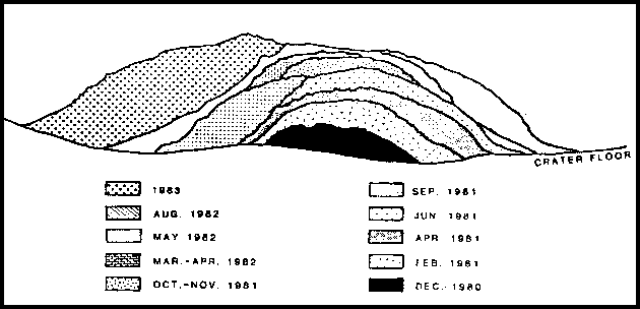 |
Figure 26. E-W profile of the composite lava dome, drawn from a succession of photographs taken from 1 km to the N. Successive lobes added to the dome December 1980-83 are shown. Growth since October 1983 is not shown. From Brantley and Topinka, 1984. |
Deformation on the N side of the dome gradually accelerated from 1 cm/day on 15 August to about 14 cm/day by the end of the month. A slight increase in the number of recorded earthquakes started on 9 August and steepening of the seismic energy release curve was evident by the 12th as occasional events in the M 1.5-2.3 range began to occur. Another slight upturn in earthquake counts started after 27 August. Rates of SO2 emission remained low in August, ranging from 12 to 37 t/d.
Deformation accelerated rapidly in early September, rising to 40 cm/day by 2 September and 70 cm/day by the 5th. Instantaneous rates of 1.5 m/day were measured early 8 September and reached 2 m/day late that afternoon. An extensive crack system defined the S margin of the zone of large-scale deformation, which included the dome's NW sector from about due N to about N70°W. On 4 and 5 September, fissuring extended from the W side of the dome across the N end of the June lobe, passing just N of the dome's summit, but it did not continue across the E side of the dome. As deformation became more rapid, rockfalls began to fill the widening fissures.
Seismic instruments began to detect increased rockfall activity on 6 September at about 2200, and earthquakes started to increase shortly thereafter. The number of small earthquakes increased further during the day 8 September. Between 0300 and 0400 on 9 September, the number of low-frequency (type L) events increased, as did the number of very small events previously termed "peppercorns," which appeared to grade upward in magnitude into the type L's. A major increase in earthquake activity continued through the day, saturating many nearby seismic stations set at maximum attenuation. At 1830, the earthquake rate began to drop, and within an hour had declined from one event every few minutes to virtually none. Simultaneously, background tremor-like activity began to build, increasing strongly through the evening. Tremor reached maximum amplitude about 0300, saturating nearby stations, and was detected by seismometers on the S side of Mt. Rainier, about 60 km away. Tremor declined about dawn on the 10th and discrete earthquakes became visible again on seismic records. Because of the tremor saturation during the night, it was not possible to determine at what time the discrete earthquakes had resumed. The number of earthquakes gradually decreased from about one every 2 minutes to 5-10/hour by the 11th.
Deformation measurements suggested that maximum rates of internal dome growth approximately coincided with the strongest seismicity. Measurements of targets on the NW side of the dome early 10 September indicated that outward movement of almost 52 m had occurred since the previous afternoon. Instantaneous rates of 15 m/day were measured between 1000 and 1030, dropping to about 10 m/day in late afternoon and a few meters per day on the 11th.
Aerial observations before dawn 10 September also showed vigorous activity. Large incandescent block-and-ash avalanches originating from three areas, two on the dome's NW flank and one on the N flank, occurred about every 5 minutes. The avalanches moved quickly down the flank and several hundred meters onto the crater floor, building an extensive talus pile. Cascades of individual blocks were continuous, occurring at rates of hundreds per minute. Avalanches had been distinctly smaller and less frequent during an overflight 8 hours earlier, and none was seen on a flight before dawn on the 9th. No new areas of incandescence were seen on the E and S sectors of the dome, although pre-existing incandescent areas had brightened somewhat.
Rates of SO2 emission also reached maximum values on 10 September, increasing from 14 t/d 30 August, to 54 t/d on 5 September, 440 t/d on the 8th, and 786 t/d on the 10th. Enhanced SO2 emission was accompanied by increased fuming and small steam-and-ash ejections. The largest rose about 1 km above the crater rim early 9 September, dropping about 1 mm of ash in the crater and a trace SE of the volcano. All of the ash in this plume was from older dome rocks.
On 12 September, geologists observed that new lava had been extruded, extending about 300 m down the NW flank. By the next day, seismicity had declined to background levels and deformation had slowed.
Reference. Brantley, S. and Topinka, L. (eds.), 1984, Volcanic Studies at the U.S. Geological Survey's David A. Johnston Cascades Volcano Observatory, Vancouver, Washington; Earthquake Information Bulletin, v. 16, no. 2, p. 43-122.
Geological Summary. Prior to 1980, Mount St. Helens was a conical volcano sometimes known as the Fujisan of America. During the 1980 eruption the upper 400 m of the summit was removed by slope failure, leaving a 2 x 3.5 km breached crater now partially filled by a lava dome. There have been nine major eruptive periods beginning about 40-50,000 years ago, and it has been the most active volcano in the Cascade Range during the Holocene. Prior to 2,200 years ago, tephra, lava domes, and pyroclastic flows were erupted, forming the older edifice, but few lava flows extended beyond the base of the volcano. The modern edifice consists of basaltic as well as andesitic and dacitic products from summit and flank vents. Eruptions in the 19th century originated from the Goat Rocks area on the N flank, and were witnessed by early settlers.
Information Contacts: M. Doukas, R. Holcomb, D. Swanson, J. Sutton, USGS CVO, Vancouver, WA; R. Norris, University of Washington; UPI.