Report on Kilauea (United States) — October 1984

Scientific Event Alert Network Bulletin, vol. 9, no. 10 (October 1984)
Managing Editor: Lindsay McClelland.
Kilauea (United States) Episode 26; shortest of 1983-84 eruption
Please cite this report as:
Global Volcanism Program, 1984. Report on Kilauea (United States) (McClelland, L., ed.). Scientific Event Alert Network Bulletin, 9:10. Smithsonian Institution. https://doi.org/10.5479/si.GVP.SEAN198410-332010
Kilauea
United States
19.421°N, 155.287°W; summit elev. 1222 m
All times are local (unless otherwise noted)
"By the end of October, 41 days had passed since the last vigorous production of lava and high fountaining on the E rift zone. However, low-level activity continued during this period. Magma was visible several tens of meters below the top of the conduit. Periodic to irregular gas-piston activity, consisting of slowly rising magma followed by low-level Strombolian activity and rapid drainback coincident with heavy degassing, occurred at intervals of minutes to hours. SO2 emissions during the interphase period remained normal at about 100 t/d.
"On 25 October, lava ponded at the top of the conduit and occasionally spilled onto the floor of Pu'u O. On 27 October, a small pahoehoe flow, similar to that preceding episode 25, moved down the N spillway approximately 300 m from the conduit. During the next five days, a small pahoehoe shield, about 100 m in diameter and 10 m high, was built above the conduit and mainly within the rim of Pu'u O. A lava temperature of 1,145°C, near the maximum measured during the 1983-84 eruption, was determined by thermocouple.
"On 2 November, a period of high fountaining, continuous lava production, and rapid summit deflation, designated as episode 26, occurred from 1140 to 1636. This was the shortest episode since the eruption began in January 1983. A comparison of the lengths of eruptive episodes and repose periods is shown in figure 31.
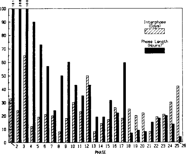 |
Figure 31. Comparison of lengths of eruptive phases (in hours) and preceding interphase periods (in days) for phases 2-26 of the E rift zone eruption. |
Deformation. "Between the end of episode 25 (20 September) and 31 October, 17 µrad of E-W inflation were recorded at the summit (Uwekahuna). This increase brought the level of inflation to its highest point since episode 21 began in late June. Geodetic measurements near Pu'u O and about 9 km uprift indicated that very little net deformation was occurring across the rift zone. EDM measurements SW of Pu'u O show that the pattern of minor pre-eruption extension and post-eruption contraction reported in August appears to be continuing. However, theodolite measurements NE of Pu'u O showed no movement above detection limits.
Seismicity. "Seismic activity was relatively low during October. In the summit area, the number of microearthquakes gradually increased corresponding to the pattern of inflation. In the middle E rift zone, the frequency of tiny shocks resulting from minor structural and thermal adjustments near Pu'u O also increased. Harmonic tremor varied in amplitude from constant, to erratic, to cyclic one-minute bursts characteristic of gas-piston activity within the Pu'u O vent."
Geological Summary. Kilauea overlaps the E flank of the massive Mauna Loa shield volcano in the island of Hawaii. Eruptions are prominent in Polynesian legends; written documentation since 1820 records frequent summit and flank lava flow eruptions interspersed with periods of long-term lava lake activity at Halemaumau crater in the summit caldera until 1924. The 3 x 5 km caldera was formed in several stages about 1,500 years ago and during the 18th century; eruptions have also originated from the lengthy East and Southwest rift zones, which extend to the ocean in both directions. About 90% of the surface of the basaltic shield volcano is formed of lava flows less than about 1,100 years old; 70% of the surface is younger than 600 years. The long-term eruption from the East rift zone between 1983 and 2018 produced lava flows covering more than 100 km2, destroyed hundreds of houses, and added new coastline.
Information Contacts: G. Ulrich, A. Okamura, and R. Koyanagi, HVO.