Report on Erebus (Antarctica) — March 1985

Scientific Event Alert Network Bulletin, vol. 10, no. 3 (March 1985)
Managing Editor: Lindsay McClelland.
Erebus (Antarctica) Explosions continue, ejecting large pumiceous bombs
Please cite this report as:
Global Volcanism Program, 1985. Report on Erebus (Antarctica) (McClelland, L., ed.). Scientific Event Alert Network Bulletin, 10:3. Smithsonian Institution. https://doi.org/10.5479/si.GVP.SEAN198503-390020
Erebus
Antarctica
77.53°S, 167.17°E; summit elev. 3794 m
All times are local (unless otherwise noted)
During November and December, about 4-12 explosions occurred per day. Many threw bombs over the crater rim, especially on the N side. The character of the activity changed in early December to high-velocity gas streaming episodes that lasted about 30 seconds each. A few bombs were entrained with the gas. Analysis of the bombs showed that they were of identical composition to the anorthoclase phonolite of previous years; no changes were noted in glass composition or SO2 content of the magma. No blocks were ejected. The explosions occurred from a small new vent in the center of the inner crater, on the S edge of the former lava lake. The vent seemed to increase in size, reaching ~30 m in diameter by late December. Sounds from the vent in late December were similar to those previously produced by degassing from the lava lake. Lava was not visible, but it was not possible to see the bottom of the vent.
In previous years, an active vent had been located just S of the SE edge of the lava lake. This vent was not present in November but reappeared in early December in a similar position. Gas streaming episodes were not observed in late December. However, the 8-16 explosion events/day recorded in February by the seismic network on the volcano were accompanied by about a dozen periods of seismicity that lasted more than a minute and appeared to be records of gas streaming episodes. Magnitudes were increasing in February after a decrease during the austral summer.
SO2 measurements using an airborne COSPEC were unsuccessful because the plume hugged the ground, dropping over the crater rim. Geologists estimated that a minimum of ~30 t/d of SO2 were being emitted, much less than the 230 t/d measured the previous austral summer. The odor of SO2 in the plume had decreased substantially from the previous year. . . . Reoccupation of a network of stations around the main crater rim (figure 5) suggested that there had been [minor but significant inflation (23 mm)] in the past year [bringing the total over the last 4 years to 45 mm (figure 6). No tilt has been detected from arrays on the outer slopes of the crater rim during that time.]
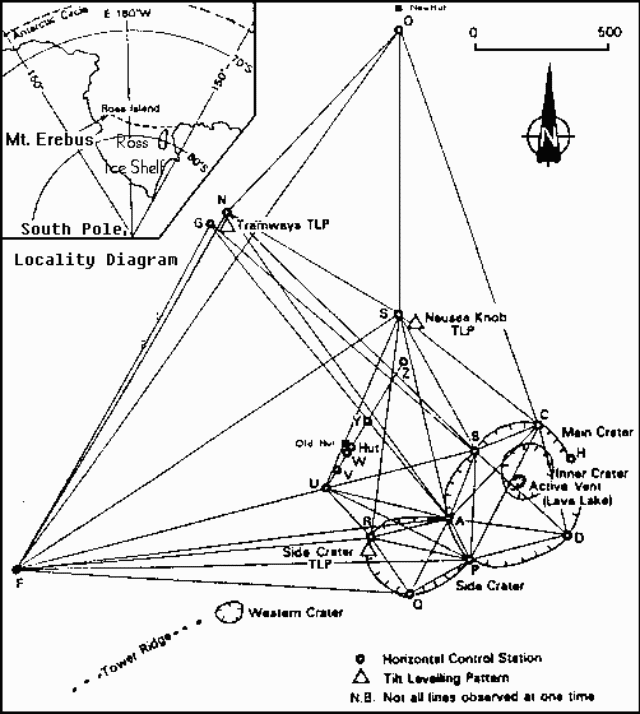 |
Figure 5. Deformation network and craters at Mt. Erebus. From Blick, 1987. |
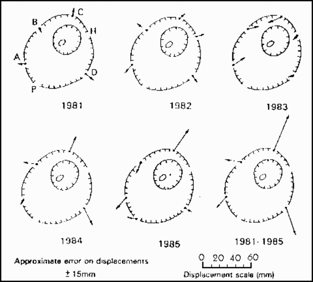 |
Figure 6. Displacements of stations around the main crater of Mt. Erebus, 1981-85. From Blick, 1987. |
Further References. Blick, G.H., 1987, Mt. Erebus, Antarctica: volcanological observations and deformation survey: New Zealand Volcanological Record, v. 15, p. 52-55.
Blick, G.H., Otway, P.M., and Scott, B.J., 1989, Deformation monitoring of Mt. Erebus, Antarctica, 1980-1985, in Latter, J.H. (ed.), Volcanic hazards; assessment and monitoring: Springer-Verlag, Berlin, Germany, p. 554-560..
Summaries of activity at Mt. Erebus in the Antarctic Journal of the United States (year described: citation); 1975: v. 11, no. 4, p. 270-271; 1977-78: v. 13, no. 4, p. 32-34; 1978-79: v. 14, no. 5, p. 35-36; 1980-81: v. 16, no. 5, p. 34; 1981-82: v. 17, no. 5, p. 29-31; 1982-83: v. 18, no. 5, p. 41-44; 1983-84: v. 19, no. 5, p. 25-27; 1984-85: v. 20, no. 5, p. 25-28.
Geological Summary. Mount Erebus, the world's southernmost historically active volcano, overlooks the McMurdo research station on Ross Island. It is the largest of three major volcanoes forming the crudely triangular Ross Island. The summit of the dominantly phonolitic volcano has been modified by one or two generations of caldera formation. A summit plateau at about 3,200 m elevation marks the rim of the youngest caldera, which formed during the late-Pleistocene and within which the modern cone was constructed. An elliptical 500 x 600 m wide, 110-m-deep crater truncates the summit and contains an active lava lake within a 250-m-wide, 100-m-deep inner crater; other lava lakes are sometimes present. The glacier-covered volcano was erupting when first sighted by Captain James Ross in 1841. Continuous lava-lake activity with minor explosions, punctuated by occasional larger Strombolian explosions that eject bombs onto the crater rim, has been documented since 1972, but has probably been occurring for much of the volcano's recent history.
Information Contacts: P. Kyle, New Mexico Inst. of Mining & Tech.; J. Kienle, Univ. of Alaska; W. Rose, Michigan Tech. Univ.; P. Otway, DSIR, Wairakei, New Zealand.