Report on Niuafo'ou (Tonga) — September 1985
Scientific Event Alert Network Bulletin, vol. 10, no. 9 (September 1985)
Managing Editor: Lindsay McClelland.
Niuafo'ou (Tonga) Earthquake swarm and pumice eruption in caldera lake
Please cite this report as:
Global Volcanism Program, 1985. Report on Niuafo'ou (Tonga) (McClelland, L., ed.). Scientific Event Alert Network Bulletin, 10:9. Smithsonian Institution. https://doi.org/10.5479/si.GVP.SEAN198509-243110
Niuafo'ou
Tonga
15.6°S, 175.63°W; summit elev. 260 m
All times are local (unless otherwise noted)
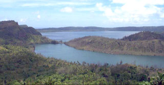
During the night of 21-22 March, an earthquake swarm with Modified Mercalli intensities as high as VII scale was felt on the island of Niuafo'ou (figure 1). A large crack formed on the NE flank, and floating pumice appeared in the caldera lake.
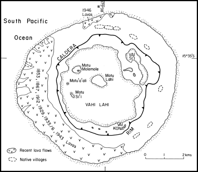 |
Figure 1. Map of Niuafo`ou, showing the distribution of historical lava flows. The outlines of caldera lakes Vai Lahi and Vai Si'i, and the solfataric area Vai Kona, are stippled. Courtesy of Paul Taylor. |
The first felt earthquake (MM IV) was at 2050 on 21 March. Strong tremors, lasting about 2 seconds each, continued for 30 minutes. A thunderous rumbling noise was heard, but it was difficult for island residents to locate its origin. Seismicity continued from 2130 to 2200 with intensities of II-IV; the tremors appeared to have a W to E motion. Between 2200 and 2300, the motion of the tremors appeared to change to E to W and intensities increased to III-V. Rumblings increased until [about] midnight when a particularly loud noise was heard and earthquake intensities increased to VI-VII. By 0100, the number of felt earthquakes had decreased and intensities had declined to III-IV. A small event of intensity II was felt at 0156. None of the earthquakes were large enough to be recorded at the Afiamalu seismic station, Upolu, Western Samoa (the nearest seismograph, about 500 km ENE of the volcano). [Villagers at Betani (Petani) and Tongamama`o (SE side of the island) reported very loud rumblings like thunder "which they estimated to have come from the reef SE (of the villages) and not from underground" (New Zealand Foreign Affairs Report Telegram, 23 March 1985, p. 2; submitted by J. Latter).]
During the night, a 250-m-long crack was discovered near the village of Fata'ulua (figure 2), extending inland from the shore. It appears that nothing was erupted from it. The RNZAF flew over the island on 23 March, and reported that it appeared normal and no destruction was observed.
 |
Figure 2. Map of the NE part of Niuafo`ou, showing the location of the March 1985 cracks (A and B); the villages affected by the earthquakes; and the approximate distribution of pumice floating in the crater lake in late May. Courtesy of Paul Taylor. |
On 24 March, Mr. Fifita, the Chief Meteorological Officer of Tonga, gave the following information to John Latter: No earthquakes were felt on Niuafo`ou after 1132 on the 22nd. Residents saw was fresh black pumice on the shore of Motu Lahi island in the caldera lake (figure 2). [A sample examined at Victoria University of Wellington was a very vesicular basaltic andesite.] From reports that he had received, Fifita estimated the extent of the pumice as 100 m long, 7 m wide, and 7-10 cm thick. There was no sign of a new crater, bubbles were not seen in the lake, nor was the lake water hot.
Further References. Rogers, G., 1981, The Evacuation of Niaufo`ou, an Outlier in the Kingdom of Tonga; Journal of Pacific History, v. 16, p. 149-163.
Taylor, P.W., 1986, Geology and Petrology of Niuafo`ou Island, Tonga; Subaerial Volcanism in an Active Back-arc Basin; New Zealand International Volcanological Congress Abstracts, p. 123.
Geological Summary. Niuafo'ou ("Tin Can Island") is a low 8-km-wide island that forms the summit of a largely submerged basaltic shield volcano in the north central Lau Basin about 170 km W of the northern end of the Tofua volcanic arc. The circular island encloses a 5-km-wide caldera that is mostly filled by a lake whose bottom extends to below sea level. The inner walls of the caldera drop sharply to the lake, named Big Lake (or Vai Lahi), which contains several small islands and pyroclastic cones on its NE shore. Eruptions recorded since 1814, mostly from circumferential fissures on the west-to-south side of the island, have often damaged villages. A major eruption in 1946 forced evacuation of most of its 1,200 inhabitants.
Information Contacts: J. Latter, DSIR, Wellington; Mr. Fifita, Chief Meteorological Officer, Tonga; R. Blong and P. Taylor, Macquarie Univ.