Report on Villarrica (Chile) — November 1985

Scientific Event Alert Network Bulletin, vol. 10, no. 11 (November 1985)
Managing Editor: Lindsay McClelland.
Villarrica (Chile) Small lava fountains and ash; increased seismicity
Please cite this report as:
Global Volcanism Program, 1985. Report on Villarrica (Chile) (McClelland, L., ed.). Scientific Event Alert Network Bulletin, 10:11. Smithsonian Institution. https://doi.org/10.5479/si.GVP.SEAN198511-357120
Villarrica
Chile
39.42°S, 71.93°W; summit elev. 2847 m
All times are local (unless otherwise noted)
The following is a report from Gustavo Fuentealba Cifuentes.
"When the last eruptive cycle of Villarrica Volcano (30 October-26 February) began to decay in January 1985, seismic activity also decreased. Between January and June 1985, the seismograph located on the N flank of the volcano recorded a monthly average of 15 volcanic earthquakes (Minakami's B-type). In February, only five seismic events were recorded with very little harmonic tremor. However, since June 1985 volcano-seismic activity has increased significantly. At the same time, notable harmonic tremor was observed. Figure 2 shows monthly seismic activity between January and November 1985. This situation was continuing as of 25 November, with a small gap in mid-late November. On 19 November at 0700, harmonic tremor stopped abruptly, and only apparently very shallow seismic activity was recorded. On 21 November at 1000, harmonic tremor activity resumed.
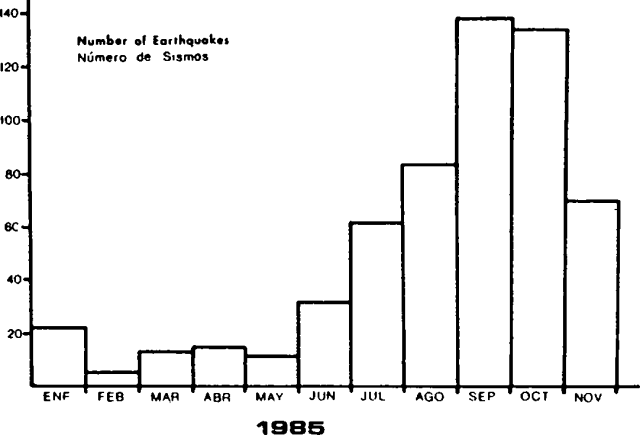 |
Figure 2. Number of earthquakes per month at Villarrica, January-November 1985. Courtesy of Gustavo Fuentealba C. |
"According to personal observations and reports from Pucón, a town at the N foot of the volcano, an increase in fumarolic activity and lava fountaining with weak explosions and very small ash emissions have been registered since April. A red glow has been seen at night since late September."
Further References. Acevedo, P., and Fuentealba, G., 1987, Antecedentes de la actividad microsísmica del volcán Villarrica relacionada con la erupción de Octubre de 1984: Boletín de Vulcanología (Universidad Nacional, Heredia, Costa Rica), no. 18, p. 13-17.
Moreno, H., Fuentealba, G., and Riffo, P. (in press), The 1984-1985 eruption of Villarrica, southern Andes of Chile (39°21'S): Basaltic Lava Flows Furrowed the Ice Cap.
Geological Summary. The glacier-covered Villarrica stratovolcano, in the northern Lakes District of central Chile, is ~15 km south of the city of Pucon. A 2-km-wide caldera that formed about 3,500 years ago is located at the base of the presently active, dominantly basaltic to basaltic-andesite cone at the NW margin of a 6-km-wide Pleistocene caldera. More than 30 scoria cones and fissure vents are present on the flanks. Plinian eruptions and pyroclastic flows that have extended up to 20 km from the volcano were produced during the Holocene. Lava flows up to 18 km long have issued from summit and flank vents. Eruptions documented since 1558 CE have consisted largely of mild-to-moderate explosive activity with occasional lava effusion. Glaciers cover 40 km2 of the volcano, and lahars have damaged towns on its flanks.
Information Contacts: G. Fuentealba C., P. Riffo A., and P. Acevedo, Univ. de La Frontera, Temuco; H. Moreno R., Univ. de Chile, Santiago.