Report on Kavachi (Solomon Islands) — February 1986
Scientific Event Alert Network Bulletin, vol. 11, no. 2 (February 1986)
Managing Editor: Lindsay McClelland.
Kavachi (Solomon Islands) Continuing submarine activity
Please cite this report as:
Global Volcanism Program, 1986. Report on Kavachi (Solomon Islands) (McClelland, L., ed.). Scientific Event Alert Network Bulletin, 11:2. Smithsonian Institution. https://doi.org/10.5479/si.GVP.SEAN198602-255060
Kavachi
Solomon Islands
8.991°S, 157.979°E; summit elev. -20 m
All times are local (unless otherwise noted)
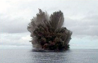
The submarine eruption . . . described in 10:12 had been observed by residents of a nearby island in early December and was continuing in late February, but had ended by 3 March.
From Saira village, roughly 25 km from Kavachi on Vangunu Island, Oliver Jino reported that the eruption sequence began on 9 December. After the previously reported observations from aircraft and ships 30 December-7 January, the next sighting was on 20 January, when Dr. G. Baines noted three ejections of water and steam, 1.5-2 minutes apart, from a Solair plane flying >45 km from the volcano. An area that looked like a coral reef but was probably volcanic debris extended downcurrent from the vent. On 24 January, Mr. B. Papukera, another Solair passenger, observed a single similar ejection. No activity was evident from a Solair plane on 5 February. On 25 February, Solair Captain Don Lemon observed renewed activity ejecting water and steam to 100 m or more asl. Two days later, Lemon again flew near the volcano, observing gas bubbles over the vent and muddy-looking water drifting away from it, but no explosions. On 3 March, personnel in a powered dinghy from the RV Thomas Washington searched the area but found no sign of activity.
Geological Summary. Named for a sea-god of the Gatokae and Vangunu peoples, Kavachi is located in the Solomon Islands south of Vangunu Island. Sometimes referred to as Rejo te Kvachi ("Kavachi's Oven"), this shallow submarine basaltic-to-andesitic volcano has produced ephemeral islands up to 1 km long many times since its first recorded eruption during 1939. Residents of the nearby islands of Vanguna and Nggatokae (Gatokae) reported "fire on the water" prior to 1939, a possible reference to earlier eruptions. The roughly conical edifice rises from water depths of 1.1-1.2 km on the north and greater depths to the SE. Frequent shallow submarine and occasional subaerial eruptions produce phreatomagmatic explosions that eject steam, ash, and incandescent bombs. On a number of occasions lava flows were observed on the ephemeral islands.
Information Contacts: D. Tuni, Ministry of Natural Resources, Honiara.