Report on Augustine (United States) — July 1986
Scientific Event Alert Network Bulletin, vol. 11, no. 7 (July 1986)
Managing Editor: Lindsay McClelland.
Augustine (United States) Slow lava dome growth; pyroclastic flows; vigorous fuming
Please cite this report as:
Global Volcanism Program, 1986. Report on Augustine (United States) (McClelland, L., ed.). Scientific Event Alert Network Bulletin, 11:7. Smithsonian Institution. https://doi.org/10.5479/si.GVP.SEAN198607-313010
Augustine
United States
59.3626°N, 153.435°W; summit elev. 1218 m
All times are local (unless otherwise noted)
Active degassing of Augustine continued following the major dome extrusion phase of 23-28 April. During field studies from late June through mid-July, no major changes were noted in the morphology of the new dome, although slow dome growth appeared to be continuing as seen by occasional dome-collapse pyroclastic flows and incandescent rockfalls. Merapi-type pyroclastic flows extending 1-2 km down the N flank were observed in late evening on 26 June, around noon 1 July, and at 2123 on 17 July. Inspection of seismic records suggested that they occurred on other occasions as well. A coarse debris flow, 1-2 m thick at its terminus, was observed on 2 July and was probably emplaced during a rainstorm the previous night. It stopped 2 km from the summit within the axial levees of the NW pyroclastic flow. The terminus of the blocky 1986 lava flow (figure 13) appeared to be at the same elevation (~600 m) as on 6 May. Active fumaroles covered much of its surface, and incandescent cracks were observed.
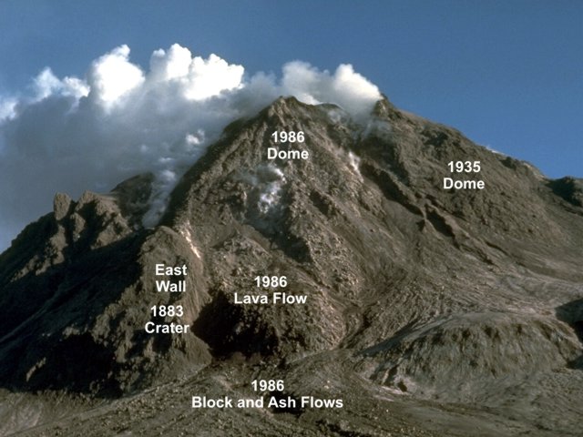 |
Figure 13. Annotated telephoto view of Augustine from the N on 14 July 1986. Portions of the area labeled "1986 Dome" may be remnants of the 1976 dome. Fumaroles obscure the E margin of the 1986 dome; remnants of the 1976 and 1964 domes on the S side of the summit crater are not visible in this view. Courtesy of Lee Siebert, SI. |
Intense fuming prevented ground observations of the dome while geologists were at the summit, but an overflight confirmed that the 1986 dome was emplaced within a crater in a remnant of the 1976 dome. The top of the new dome was lower than the crescent-shaped remnant of the 1964 dome on the S side of the crater, and was roughly comparable to the elevation of the 1935 dome remnant on the NW side. The most vigorous fuming originated from vents in the moat between the new dome and a ramp below the 1964 dome.
Maximum gas temperatures measured by Bob Symonds at summit crater fumaroles were 625-645°C. Fumarole condensates had a pH of between 0 and 0.5. Measured fumarole temperatures on 1986 pyroclastic flow deposits on the N flank varied from about 200 to 250°C; pH values ranged from 0 to 1. During an overflight on 24 July at about noon, COSPEC measurements by Symonds indicated that the SO2 flux of the plume was 380 ± 45 t/d, a value comparable to that observed at Mt. St. Helens in December 1980.
Heat flow measurements from steel pipes inserted in the pyroclastic flows recorded a maximum temperature of 525°C at 6.16 m depth on the NW flow on 12 July. An adjacent hole showed isothermal convection at the boiling point for the upper 1.20 m and apparently penetrated through the flow, producing a reverse temperature gradient (figure 14). NE flow holes encountered large lithic blocks at shallow depths; 3l5°C temperatures were measured at the maximum depth of 2.58 m on 16 July.
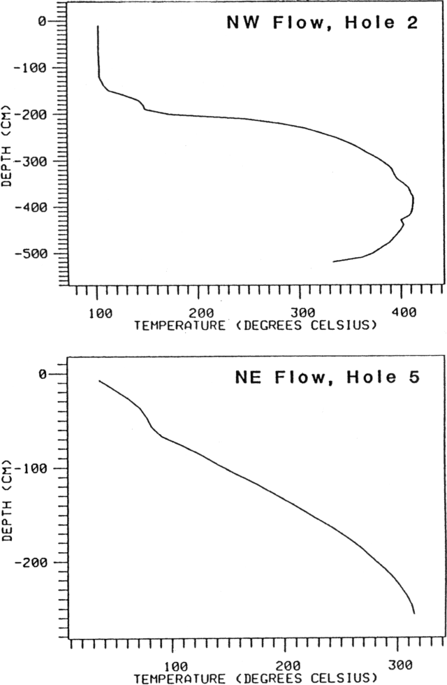 |
Figure 14. Temperature profiles from NW (top) and NE (bottom) pyroclastic flow lobes. The data were obtained from just NW of point 1 and at point 2, respectively, of figure 7. Note that both depth and temperature scales are different. Courtesy of Juergen Kienle. |
Since 10 May the daily number of rockfall avalanches or Merapi-type pyroclastic flows declined to about a half dozen/day (see 11:04 for pre- 10 May data). A modest increase in daily events to 30-40/day was noted beginning 13-14 August. At press time continuous noise on seismic records from 0006 to 0200 on 20 August indicated that an explosive eruption had taken place. Pilots reported ash and steam emission that afternoon and noted new pyroclastic flows extending 3/4 of the way down the N and NE flanks.
Geological Summary. Augustine volcano, rising above Kamishak Bay in the southern Cook Inlet about 290 km SW of Anchorage, is the most active volcano of the eastern Aleutian arc. It consists of a complex of overlapping summit lava domes surrounded by an apron of volcaniclastic debris that descends to the sea on all sides. Few lava flows are exposed; the flanks consist mainly of debris-avalanche and pyroclastic-flow deposits formed by repeated collapse and regrowth of the summit. The latest episode of edifice collapse occurred during Augustine's large 1883 eruption; subsequent dome growth has restored the edifice to a height comparable to that prior to 1883. The oldest dated volcanic rocks on Augustine are more than 40,000 years old. At least 11 large debris avalanches have reached the sea during the past 1,800-2,000 years, and five major pumiceous tephras have been erupted during this interval. Recorded eruptions have typically consisted of explosive activity with emplacement of pumiceous pyroclastic-flow deposits followed by lava dome extrusion with associated block-and-ash flows.
Information Contacts: J. Kienle and Tony Limke, Geophysical Institute, University of Alaska, Fairbanks; Robert Symonds, Michigan Technological Univ; Lee Siebert, SI.