Report on St. Helens (United States) — October 1986

Scientific Event Alert Network Bulletin, vol. 11, no. 10 (October 1986)
Managing Editor: Lindsay McClelland.
St. Helens (United States) Strong seismicity and tilt with October extrusion
Please cite this report as:
Global Volcanism Program, 1986. Report on St. Helens (United States) (McClelland, L., ed.). Scientific Event Alert Network Bulletin, 11:10. Smithsonian Institution. https://doi.org/10.5479/si.GVP.SEAN198610-321050
St. Helens
United States
46.2°N, 122.18°W; summit elev. 2549 m
All times are local (unless otherwise noted)
In late October, Mt. St. Helens completed its second dome-building episode of 1986, about 5 months after the previous episode (SEAN 11:04 and 11:05). After 3 weeks of increasing precursory activity, the new lobe began to emerge from a fissure near the center of the dome during the night of 21-22 October (SEAN 11:09).
The new lobe had added 10 m to the height of the dome by the morning of 22 October, and 20 meters more by the next day, when the [lobe's] dimensions were estimated at 200-300 m by 200 m by 40-45 m thick. Extrusion was slow enough that wooden marker posts on top of the dome remained erect even when carried for tens of meters. Time-lapse film showed the new lava pushing upward through a N-S fissure, rising vertically, and collapsing to the sides in sheet-like masses. When geologists were next able to enter the crater, on 3 November, extrusion had ended and the dome had subsided 10 m. With earlier dome-building episodes, more typical values for post-extrusion subsidence have been 3-4 m. The new lobe appeared morphologically and petrographically similar to the May 1986 and September 1984 lobes, which were disrupted and partially buried by this extrusion episode (figures 34 and 35). Fractures 30 m deep and 30 m wide extended almost completely through the September lobe.
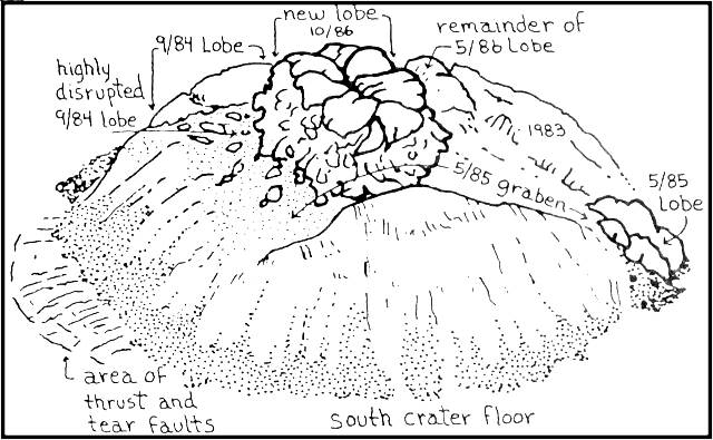 |
Figure 34. Drawing by Bobbie Myers of the primary features of the composite lava dome at Mt. St. Helens as of 28 October. |
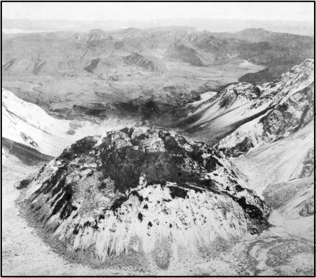 |
Figure 35. Oblique airphoto by Lyn Topinka on 28 October, looking N, showing the lava dome at Mt. St. Helens, the crater breach, Spirit Lake (middle distance), and Mt. Rainier (background). |
Thrust faults on the crater floor SW of the dome disrupted debris along a 400-500-m sector. From horizontal displacement measurements on the W side of the dome, just N of the faults, Don Swanson estimates that fault offset was 7 m. Tear faults, some showing strike-slip movement, bounded the thrust blocks.
The October dome-building episode released much more seismic energy than that of May 1986. Most earthquake magnitudes were near or slightly below 3. The high energy release seemed to result from the large number of surface events during the breakup of the oversteepened May and September lobes, and the development of thrust faults in the crater floor.
Tiltmeters recorded consistent outward co-seismic tilting on all four flanks of the dome. The strongest occurred on the W flank, where 11° of outward tilt was recorded before the instrument was destroyed at 0400 on 22 October. Just under 1° of tilt (15,000 µrads) was recorded on the N flank. The S and E flanks tilted outward 4,500 and 4,000 µrads, then several hundred µrads inward after extrusion of the lobe. The N flank did not show a similar relaxation. Total horizontal displacement along EDM lines reached 5-10 m on the SW flank (before that target was destroyed on 22 October) and 7 m on the W flank.
SO2 emissions peaked at 675 ± 50 t/d on 22 October, up from 550 ± 50 t/d on 21 October. Emission rates decreased to 260 ± 50 t/d on 23 October and 160 ± 15 t/d by 24 October.
Stationary magnetometers on the dome's SE flank and base recorded no change in field intensity during the event. In the past, handheld magnetometer data had indicated that the dome magnetized at the rate of a few gammas/day after extrusion of a new lobe.
Geological Summary. Prior to 1980, Mount St. Helens was a conical volcano sometimes known as the Fujisan of America. During the 1980 eruption the upper 400 m of the summit was removed by slope failure, leaving a 2 x 3.5 km breached crater now partially filled by a lava dome. There have been nine major eruptive periods beginning about 40-50,000 years ago, and it has been the most active volcano in the Cascade Range during the Holocene. Prior to 2,200 years ago, tephra, lava domes, and pyroclastic flows were erupted, forming the older edifice, but few lava flows extended beyond the base of the volcano. The modern edifice consists of basaltic as well as andesitic and dacitic products from summit and flank vents. Eruptions in the 19th century originated from the Goat Rocks area on the N flank, and were witnessed by early settlers.
Information Contacts: D. Swanson, D. Dzurisin, E. Endo, and P. Pringle, CVO; C. Jonientz-Trisler, University of Washington.