Report on Akutan (United States) — January 1987
Scientific Event Alert Network Bulletin, vol. 12, no. 1 (January 1987)
Managing Editor: Lindsay McClelland.
Akutan (United States) Steam and ash emission
Please cite this report as:
Global Volcanism Program, 1987. Report on Akutan (United States) (McClelland, L., ed.). Scientific Event Alert Network Bulletin, 12:1. Smithsonian Institution. https://doi.org/10.5479/si.GVP.SEAN198701-311320
Akutan
United States
54.134°N, 165.986°W; summit elev. 1303 m
All times are local (unless otherwise noted)
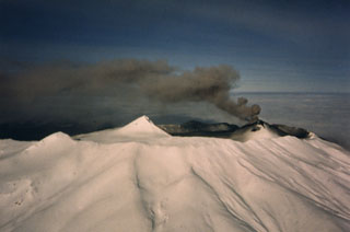
From 5 January to 11 February intermittent steam and ash plumes were reported from a cinder cone (table 1). Minor ashfall occurred at Akutan village on 1 February.
Table 1. Summary of reports of activity at Akutan, 5 January-3 March 1987, collected by J. Reeder. Observers (initials in brackets): Tom Madsen, Aleutian Air; Harold Wilson, Guy Morgan, Theresa Dubber (passenger), Nick Sias, Peninsula Airways; Lee Goch, Don Munson, Janice Reeve Ogle, Reeve Aleutian Airways; David McGlashan, Akutan village; Teddy Jepsen, Trident Sea Foods Corp., Akutan; Jerry Chisum and Ray Wells, Markair; Captain Mets and the 17th Tactical Airlift Squadron; Julie Hathaway and Abi Dickson, Unalaska; Stan Carrick and Ed Collazzi, State of Alaska Hydrologists.
| Date | Time | Activity [with observers] |
| 05 Jan 1987 | 1150 | Above-average steaming and sulfuric odors [TM]. |
| 05 Jan 1987 | 1600 | Steam plume rose 180 m above the cinder cone; melted snow left black areas on the cone [HW]. |
| 31 Jan 1987 | 1100 | Steam and ash plume drifted NW [TM]. |
| 31 Jan 1987 | 1500 | Minor steam emission [LG, DM, JO]. |
| 02 Feb 1987 | 1030 | Vertical ash plume grew to 900 m; upper N flank covered with fresh ash [TJ]. |
| 02 Feb 1987 | 1445 | No ash or steam emissions [LG, JF]. |
| 03 Feb 1987 | 1435 | 530-m-high steam-and-ash plume; most ash emitted from an upper NW-flank vent on the cinder cone; steam plume on the upper S flank [TM]. |
| 03 Feb 1987 | 1510 | 180-m-high plume drifting 9 km NE; ash covered the caldera [GM, TD]. |
| 07 Feb 1987 | 1220 | Dark-brown ash plume extended 5.5 km NE; plume was gone 1 hour later [JC]. |
| 10 Feb 1987 | 1950 | Plume reached 4,900 m altitude (summit altitude is 1,300 m) and drifted 8 km N [CM]. |
| 11 Feb 1987 | a.m. | Gray ash plume rose continuously; drifted SW; fresh black ash visible on upper N flank [TJ]. |
| 11 Feb 1987 | 1015 | Plume reached 300 m above the summit; drifted 65-75 km WSW [TM]. |
| 11 Feb 1987 | 1247 | Dark brownish-gray plume rose to 2,100 m altitude, drifted W [JC]. |
Geological Summary. Akutan contains a 2-km-wide caldera with a large cinder cone in the NE part of the caldera that has been the source of frequent explosive eruptions and occasional lava effusion that covers the caldera floor. An older, largely buried caldera was formed during the late Pleistocene or early Holocene. Two volcanic centers are located on the NW flank. Lava Peak is of Pleistocene age, and a cinder cone lower on the flank produced a lava flow in 1852 that extended the shoreline of the island and forms Lava Point. The 60-365 m deep younger caldera was formed during a major explosive eruption about 1,600 years ago and contains at least three lakes. A lava flow in 1978 traveled through a narrow breach in the north caldera rim almost to the coast. Fumaroles occur at the base of the caldera cinder cone, and hot springs are located NE of the caldera at the head of Hot Springs Bay valley and along the shores of Hot Springs Bay.
Information Contacts: J. Reeder, ADGGS.