Report on Banda Api (Indonesia) — June 1987
Scientific Event Alert Network Bulletin, vol. 12, no. 6 (June 1987)
Managing Editor: Lindsay McClelland.
Banda Api (Indonesia) Small plume observed after large earthquake
Please cite this report as:
Global Volcanism Program, 1987. Report on Banda Api (Indonesia) (McClelland, L., ed.). Scientific Event Alert Network Bulletin, 12:6. Smithsonian Institution. https://doi.org/10.5479/si.GVP.SEAN198706-265090
Banda Api
Indonesia
4.523°S, 129.881°E; summit elev. 596 m
All times are local (unless otherwise noted)
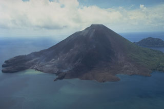
A M 6.7 tectonic earthquake occurred 150 km SE of Banda Api on 17 June (preliminary epicenter 5.58°S, 130.88°E). Activity consisting of a white plume, reaching 100 m above Banda Api's crater, was reportedly observed after the earthquake. However, photographs taken during a climb to the crater 24-26 April showed no plume or gas emission.
Geological Summary. The 3-km-wide island of Banda Api is the northern-most volcano in the Banda arc and has a long period of recorded observation because of its key location in the Portuguese and Dutch spice trade. The basaltic-to-rhyodacitic volcano is located in the SW corner of a mostly submerged 7 km caldera. At least two episodes of caldera formation are thought to have occurred, with the arcuate islands of Lonthor and Neira considered to be pre-caldera remnants. A conical peak rises to about 600 m at the center of the island. Eruptions have been recorded since 1586 CE, mostly consisting of Strombolian eruptions from the summit crater, but larger explosive eruptions have occurred and occasional lava flows have reached the coast.
Information Contacts: VSI.