Report on Ol Doinyo Lengai (Tanzania) — August 1987

Scientific Event Alert Network Bulletin, vol. 12, no. 8 (August 1987)
Managing Editor: Lindsay McClelland.
Ol Doinyo Lengai (Tanzania) Eruptive history January 1983-June 1987
Please cite this report as:
Global Volcanism Program, 1987. Report on Ol Doinyo Lengai (Tanzania) (McClelland, L., ed.). Scientific Event Alert Network Bulletin, 12:8. Smithsonian Institution. https://doi.org/10.5479/si.GVP.SEAN198708-222120
Ol Doinyo Lengai
Tanzania
2.764°S, 35.914°E; summit elev. 2962 m
All times are local (unless otherwise noted)
The following . . . is a compilation of reports from visitors to the volcano since 1983. Names of sources are in parentheses after their information. [See Nyamweru, 1988, for a more detailed version.]
Photographs taken on a flight over the crater in early April 1983 showed a narrow tongue of black lava stretching from the base of the N wall over more than half of the ~180-m-wide crater floor (figure 1) (Croze and Fanshawe). Three months later, in July, a group visited the crater rim and observed that on the upper 10% of the outer slopes vegetation had died and a thin layer of white ash had fallen. Many fissures along the rim of the N crater were issuing clouds of sulfurous steam and sulfur crystals were forming in cracks in the ground. The N crater appeared shallower than it had before the eruption of early 1983. Very liquid, dark colored "mud" was ejected at intervals to heights of ~2-3 m, from two or three small vents at the N end of the crater, with a noise similar to ocean surf (Peterson).
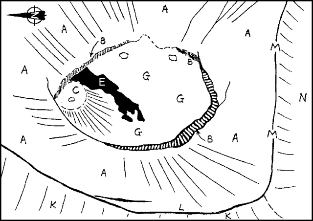 |
Figure 1. Near-vertical aerial view of Ol Doinyo Lengai's N crater in early April 1983. Traced from photo by J. Fanshawe; courtesy of C. Nyamweru. Key: A: Upper segment of crater wall, sloping and crossed by shallow rills. Most parts are light gray to brown in color. B: Vertical to near-vertical lower segment of crater wall. C: Small ash cones; color ranges from black (fresh) to pale gray (weathered). D: Dark gray to black lava, rough surface (aa?). E: Dark gray to black lava, smooth surface often with flow structures (pahoehoe?) F: Talus slope. G: Crater floor with no sign of recent lava flows (within the last few weeks or months); mid-pale gray or almost white in color. J: Bank of pale gray ash (?). K: Outer flanks; mid-gray to brown surface of indurated pyroclasts. Variable vegetation. L: Crater rim. M: Saddle separating the larger, active, lower part of N crater from smaller, inactive, higher S corner. |
During a May 1984 visit, two vents on the N side of the crater floor (figure 2) contained a black bubbling liquid that was occasionally thrown an estimated 6 m into the air (Trott). Three months later, on 2 August 1984, dark gray to black, ropy, mud-like crust had formed over the inside surface of the inner crater (surface G in figure 2). On the N side of the crater floor, a small cluster of cones, ~3 m high, ejected small blobs of mud-like lava. A continuous deep rumbling occurred from within the crater (Skelton). By February 1985, a lake that was very black, quite liquid, and boiling vigorously, covered ~1/4 of the crater floor (Borner). In October 1985, the lake was covered with a solid crust, but three cones, ~3 m high, had formed. The largest one, on the W side, had bubbling black "mud" inside, that was being thrown violently towards the cone's rim (Borner).
A group spent two hours on the crater floor on 27 December 1985. The crater floor was generally flat with a 10-m rock "spine" (probably made of lava) near the N end. A number of deep holes in the crater floor led into tunnels that emitted steam with considerable force. The fissures described by Peterson in 1983 also continued to emit steam and sulfurous fumes. Noise and tremor seemed to originate from below the crater at 5- to 30-minute intervals (Waldron). Lava samples from the crater floor were analyzed and found to be natrocarbonatite, consisting almost entirely of nyerereite and gregoryite. A thin section showed clear tabular nyerereite and cloudy rounded gregoryite phenocrysts in a finely crystalline groundmass that was primarily carbonate minerals (Hay). The texture and composition of this lava was very similar to those formed in [1960 and 1966].
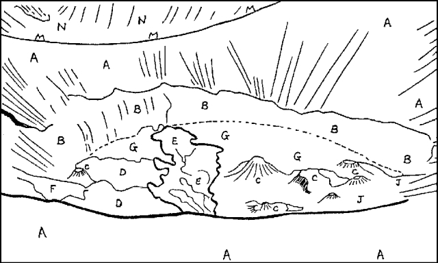 |
Figure 2. Ol Doinyo Lengai's N crater seen from the rim in May 1984. North is to the right or the lower right corner. See figure 1 for key. Traced from photo by F. Trott; courtesy of C. Nyamweru. |
On 1 May 1986 the same group found that the tunnels beneath the crater had all been filled by more recent flows and there were three small peaks (instead of one), each ~8 m high. Eruption of clots of "brownish dark cement" was occurring every few seconds from a small vent near the top of one of the peaks. Very fresh-looking, dark brown, ropy lava had spread out around the base of the peaks and extended several tens of meters from the base of the cone (Waldron).
In November 1986 there was a considerably larger area of dark fresh-looking lava visible on the N side of the crater than there had been in May. Several small vents were concentrated towards the N side of the crater and at least three were throwing out clots of lava. Black lava had flowed into the crater from a small cone on the crater rim that formed between July 1984 and July 1985. The crater appeared shallower than it had been in 1983; the vertical cliff that had formed the lower segment of the slope (area B in figure 2) into the crater had completely disappeared, and at the S end of the crater the slope above it was also much shorter than it was in 1983. Very roughly, some 10-20 m of vertical slope could have been lost due to infilling by the volcanic material erupted since 1983 (Peterson).
In February 1987 an aerial view of the crater (figure 3) confirmed the crater's shallow appearance. The crater floor also looked much paler than in November 1986, suggesting that the lava surface had undergone characteristic alteration and little new material had been erupted in the previous few weeks. On 30 June 1987, a couple of small vents on the N side were still active. The vent on the N rim had grown some since last seen in November 1986 (Peterson).
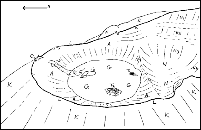 |
Figure 3. Ol Doinyo Lengai on 4 February 1987, traced by C. Nyamweru from photograph by Adrian Warren and Keith Scholey. Key: C1: Rim cone apparently formed between July 1984 and June 1985. D: Possible lava flow originating from a vent on the N wall of the crater. N1-N4: Steep sections of the wall of the inactive S corner of the N crater, green with vegetation. T1-T3: Small features similar to lava domes or blisters on the crater floor; they were partially collapsed with vents a few meters in diameter. (see figure 1 caption for key to other features). |
Reference. Nyamweru, C., 1988, Activity of Ol Doinyo Lengai volcano, Tanzania, 1983-1987: Journal of African Earth Science, v. 7, p. 603-610.
Geological Summary. The symmetrical Ol Doinyo Lengai is the only volcano known to have erupted carbonatite tephras and lavas in historical time. The prominent stratovolcano, known to the Maasai as "The Mountain of God," rises abruptly above the broad plain south of Lake Natron in the Gregory Rift Valley. The cone-building stage ended about 15,000 years ago and was followed by periodic ejection of natrocarbonatitic and nephelinite tephra during the Holocene. Historical eruptions have consisted of smaller tephra ejections and emission of numerous natrocarbonatitic lava flows on the floor of the summit crater and occasionally down the upper flanks. The depth and morphology of the northern crater have changed dramatically during the course of historical eruptions, ranging from steep crater walls about 200 m deep in the mid-20th century to shallow platforms mostly filling the crater. Long-term lava effusion in the summit crater beginning in 1983 had by the turn of the century mostly filled the northern crater; by late 1998 lava had begun overflowing the crater rim.
Information Contacts: C. Nyamweru, Kenyatta Univ, Nairobi, Kenya.