Report on Mahawu (Indonesia) — August 1987
Scientific Event Alert Network Bulletin, vol. 12, no. 8 (August 1987)
Managing Editor: Lindsay McClelland.
Mahawu (Indonesia) 1977 lake data corrected
Please cite this report as:
Global Volcanism Program, 1987. Report on Mahawu (Indonesia) (McClelland, L., ed.). Scientific Event Alert Network Bulletin, 12:8. Smithsonian Institution. https://doi.org/10.5479/si.GVP.SEAN198708-266110
Mahawu
Indonesia
1.352°N, 124.865°E; summit elev. 1299 m
All times are local (unless otherwise noted)
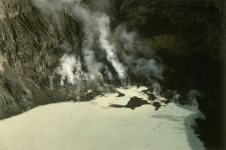
During the November 1977 visit by Nairn and Bachri, the crater lake was 80 m in diameter and its temperature was 65.5°C (correcting the values reported in 12:07). Lake depth was estimated at 10 m by a guide, based on his earlier observation of the crater floor at a time when the lake was dry. The explosions from the lake were quite small.
Geological Summary. The elongated Mahawu volcano immediately east of Lokon-Empung volcano is the northernmost of a series of young volcanoes along a SSW-NNE line near the margin of the Quaternary Tondano caldera. Mahawu is capped by a 180-m-wide, 140-m-deep crater that sometimes contains a small crater lake, and has two pyroclastic cones on its N flank. Historical activity has been restricted to occasional small explosive eruptions recorded since 1789. In 1994 fumaroles, mudpots, and small geysers were observed along the shores of a greenish-colored crater lake.
Information Contacts: I. Nairn, NZGS Rotorua, New Zealand.