Report on Kilauea (United States) — August 1987

Scientific Event Alert Network Bulletin, vol. 12, no. 8 (August 1987)
Managing Editor: Lindsay McClelland.
Kilauea (United States) Lava production continues; deep tremor
Please cite this report as:
Global Volcanism Program, 1987. Report on Kilauea (United States) (McClelland, L., ed.). Scientific Event Alert Network Bulletin, 12:8. Smithsonian Institution. https://doi.org/10.5479/si.GVP.SEAN198708-332010
Kilauea
United States
19.421°N, 155.287°W; summit elev. 1222 m
All times are local (unless otherwise noted)
The low-level eruptive activity . . . continued through August. Lava advanced SE from the vent area through well-developed tubes over the steep slope of a major fault scarp ("pali") threatening only the E end of Royal Gardens Subdivision and covering a small portion of an unused access road. At ~150 m elevation, lava moved slightly W of earlier flows, and by the end of the month the flow front had advanced to ~25 m elevation, 1 km from the ocean. During the first week of September, lava overrode earlier flows that covered Hwy 130, and the most active part of the 200-m-wide flow, along its W margin, had moved to within 100 m of the Chain of Craters Road inside the national park (figure 52). A small lobe was approaching the ocean E of the park, but advance was only sporadic. The level of the lava pond over the vent continued to vary, with a few small, brief overflows onto the shield during the month. Most of the lava emptied from the neck at the SE end of the pond into the tube system.
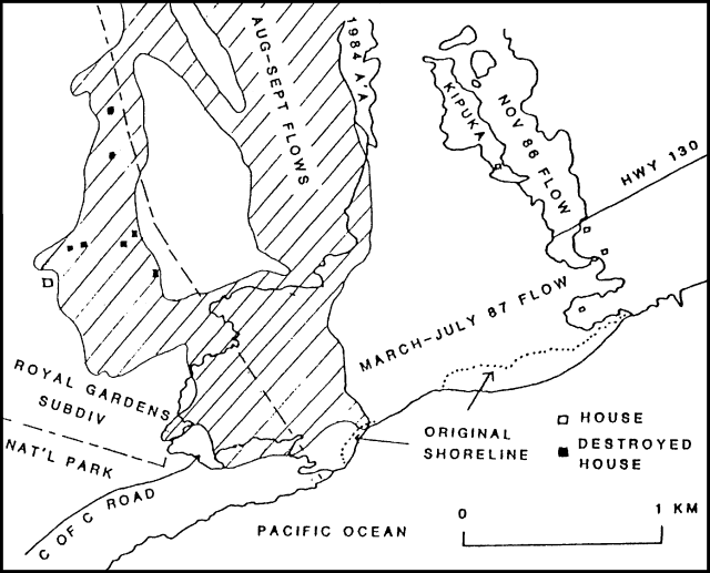 |
Figure 52. Kīlauea's recent lava flows near the S coast. The hachured area is a preliminary sketch of the August-September flows; outlines of other flows are based on airphoto data. Filled squares represent houses destroyed in September. |
Harmonic tremor continued at a low level below the shield vent and Pu`u `O`o. Tremor occasionally varied at intervals of a few hours, but generally remained constant for periods of a few days. Bursts of 40-60-km-deep tremor SW of Kīlauea became increasingly frequent during the last half of the month after three weeks of relative quiet. By mid-August, the number of seismic events beneath Pu`u `O`o (structural adjustments after the 26 June conduit collapse event) had declined considerably, from ~200 shallow microshocks/day in July to ~50/day in late August. There were no unusually significant earthquakes in August; eight had magnitudes of 2.5-4.2. Most occurred in persistent seismic source areas 5-10 km deep in the S flanks of Kīlauea and Mauna Loa.
Geological Summary. Kilauea overlaps the E flank of the massive Mauna Loa shield volcano in the island of Hawaii. Eruptions are prominent in Polynesian legends; written documentation since 1820 records frequent summit and flank lava flow eruptions interspersed with periods of long-term lava lake activity at Halemaumau crater in the summit caldera until 1924. The 3 x 5 km caldera was formed in several stages about 1,500 years ago and during the 18th century; eruptions have also originated from the lengthy East and Southwest rift zones, which extend to the ocean in both directions. About 90% of the surface of the basaltic shield volcano is formed of lava flows less than about 1,100 years old; 70% of the surface is younger than 600 years. The long-term eruption from the East rift zone between 1983 and 2018 produced lava flows covering more than 100 km2, destroyed hundreds of houses, and added new coastline.
Information Contacts: C. Heliker and R. Koyanagi, HVO.