Report on Sirung (Indonesia) — December 1987
Scientific Event Alert Network Bulletin, vol. 12, no. 12 (December 1987)
Managing Editor: Lindsay McClelland.
Sirung (Indonesia) Fumaroles and crater lake normal after earthquake
Please cite this report as:
Global Volcanism Program, 1987. Report on Sirung (Indonesia) (McClelland, L., ed.). Scientific Event Alert Network Bulletin, 12:12. Smithsonian Institution. https://doi.org/10.5479/si.GVP.SEAN198712-264270
Sirung
Indonesia
8.508°S, 124.13°E; summit elev. 862 m
All times are local (unless otherwise noted)
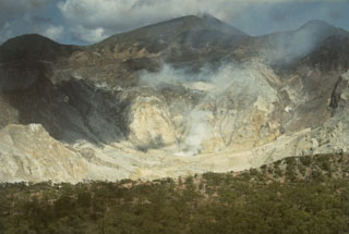
A VSI observer visited the volcano on 12 December. Fumaroles and the crater lake were normal and showed no evidence of increased activity that might be attributed to the M 6.5 earthquake of 26 November (preliminary epicenter 8.35°S, 124.25°E). The only notable change in the crater was a fresh landslide scar that may have resulted from the earthquake.
Geological Summary. Sirung volcano is located at the NE end of a 14-km-long line of volcanic centers that form a peninsula at the southern end of Pantar Island. The volcano is truncated by a 2-km-wide caldera whose floor often contains one or more small lakes. Much of the volcano is constructed of basaltic lava flows, and the Gunung Sirung lava dome forms the high point on the caldera's western rim. A number of phreatic eruptions have occurred from vents within the caldera during the 20th century. Forested Gunung Topaki, the high point of the volcanic chain, lies at the SW end and contains a symmetrical summit crater.
Information Contacts: VSI.