Report on Las Pilas-El Hoyo Complex (Nicaragua) — January 1988
Scientific Event Alert Network Bulletin, vol. 13, no. 1 (January 1988)
Managing Editor: Lindsay McClelland.
Las Pilas-El Hoyo Complex (Nicaragua) Gas emission continuing from 1952 fissure
Please cite this report as:
Global Volcanism Program, 1988. Report on Las Pilas-El Hoyo Complex (Nicaragua) (McClelland, L., ed.). Scientific Event Alert Network Bulletin, 13:1. Smithsonian Institution. https://doi.org/10.5479/si.GVP.SEAN198801-344080
Las Pilas-El Hoyo Complex
Nicaragua
12.4922°N, 86.6786°W; summit elev. 1088 m
All times are local (unless otherwise noted)
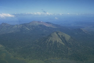
The [summit-area] fissure formed in the 1952 eruption was still emitting gas on 16 January 1988. Another small eruption was reported in 1954.
Geological Summary. Las Pilas-El Hoyo volcanic complex, overlooking Cerro Negro volcano to the NW, includes a diverse cluster of cones within about a 3-km-diameter area. A N-S-trending fracture system cutting across the edifice is marked by numerous flank vents, including maars, that are part of a 30-km-long volcanic massif. The Cerro Negro chain of cinder cones is listed separately in this compilation because of its extensive historical eruptions and possible distinct magmatic system. The lake-filled Asososca maar is located adjacent to the Cerro Asososca cone on the southern side of the fissure system, south of the axis of the Marrabios Range. Two small maars west of Lake Managua are located at the southern end of the fissure. Aside from a possible eruption in the 16th century, eruptions of Las Pilas took place in the 1950s from a fissure that cuts the eastern side of the 700-m-wide crater and extends down the N flank.
Information Contacts: B. van Wyk de Vries, H. Rymer, and G. Brown, Open Univ; P. Hradecky and H. Taleno, INETER.