Report on Etna (Italy) — March 1988
Scientific Event Alert Network Bulletin, vol. 13, no. 3 (March 1988)
Managing Editor: Lindsay McClelland.
Etna (Italy) Inflation and seismicity
Please cite this report as:
Global Volcanism Program, 1988. Report on Etna (Italy) (McClelland, L., ed.). Scientific Event Alert Network Bulletin, 13:3. Smithsonian Institution. https://doi.org/10.5479/si.GVP.SEAN198803-211060
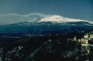
Etna
Italy
37.748°N, 14.999°E; summit elev. 3357 m
All times are local (unless otherwise noted)
The following is from a joint French (CNRS/PIRPSEV)-Italian (CNR) monitoring program.
Ground deformation and microseismicity data are transmitted by an ARGOS satellite station, 1 km SSE of the central craters at 2,920 m asl (near the Torre del Filosofo). Two tiltmeters and a vertical geophone are installed inside a 50-m-long lava tube.
From November 1987 through January 1988, no ground deformation was detected and microseismicity was at a low level (100 events/day). In February, ~ 3 µrads/day of nearly continuous inflation was measured by the N-S component of the tilt instrumentation, but E-W tilt remained essentially flat (figure 26). Microseismicity remained at a low level until 25 February, when both the number of events and noise amplitude began to increase (figure 27). A sharp (30 µrad) N-S deflation occurred 29 February-1 March, with a further increase in the number of events (to 700-950/day) and noise amplitude.
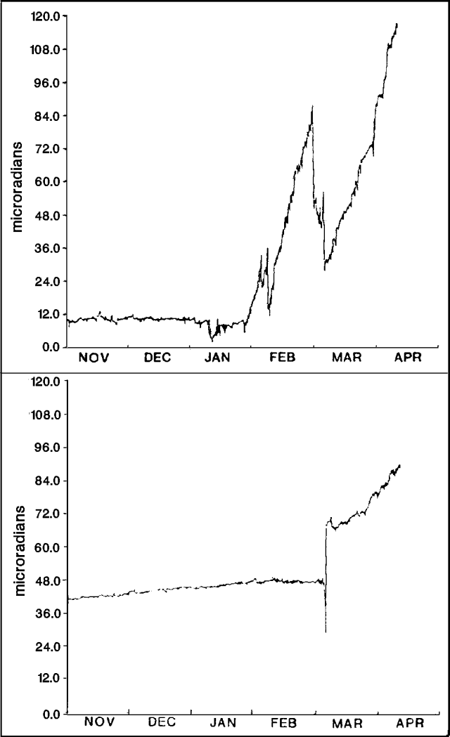 |
Figure 26. Summit tilt measured 1 November 1987-10 April 1988 by the N-S (top), and E-W (bottom) components at site TDF, 1 km SSE of the central craters at 2920 m asl (near the Torre del Filosofo). Courtesy of the joint French-Italian Etna survey program. |
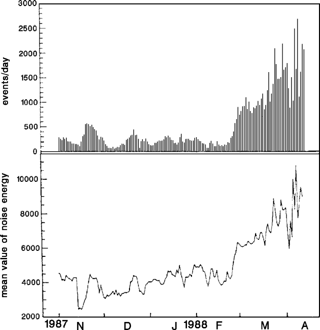 |
Figure 27. Number of seismic events/day with amplitudes >4 Nm (top), and daily mean value of noise energy (bottom), measured at site TDF, 1 November 1987-12 April 1988. Courtesy of the joint French-Italian Etna survey program. |
Seismicity continued to build 1-5 March, to 1,100 earthquakes/day. An additional 15 µrad of N-S deflation 5 March was accompanied by the onset of 20 µrad of rapid uplift to the E. From 5 March through early April, NNE-trending inflation has continued at ~ 4 µrad/day, and microseismicity has remained strong, reaching a maximum of 2,700 shocks/day on 8 April. Since the end of February, the 10-station ARGOS seismic network has located many shallow earthquakes in the NE quadrant of the volcano. Local and regional networks have recorded many earthquakes on Sicily's E coast, especially near Etna. Some reached M3 with hypocenters deeper that 10 km. One was felt during the night of 1-2 April by residents of Santa Venerina (15 km SSE of the summit) and Guardia-Mangano (18 km SSE). The ground deformation and microseismicity data suggested to the French/Italian team that significant stress modifications had been located beneath the central craters, and these have since moved to the E flank. No magma had reached the surface as of early April and degassing activity from Bocca Nuova and Southeast Crater remained normal.
Geological Summary. Mount Etna, towering above Catania on the island of Sicily, has one of the world's longest documented records of volcanism, dating back to 1500 BCE. Historical lava flows of basaltic composition cover much of the surface of this massive volcano, whose edifice is the highest and most voluminous in Italy. The Mongibello stratovolcano, truncated by several small calderas, was constructed during the late Pleistocene and Holocene over an older shield volcano. The most prominent morphological feature of Etna is the Valle del Bove, a 5 x 10 km caldera open to the east. Two styles of eruptive activity typically occur, sometimes simultaneously. Persistent explosive eruptions, sometimes with minor lava emissions, take place from one or more summit craters. Flank vents, typically with higher effusion rates, are less frequently active and originate from fissures that open progressively downward from near the summit (usually accompanied by Strombolian eruptions at the upper end). Cinder cones are commonly constructed over the vents of lower-flank lava flows. Lava flows extend to the foot of the volcano on all sides and have reached the sea over a broad area on the SE flank.
Information Contacts: C. Archambault, Centre National d'Etudes des Telécommunications; F. Barberi, Univ di Pisa; R. Basile, Osservatorio Sismologico, Acireale; P. Briole and C. Pambrun, IPGP; J. Glot, IRIGM; J. Liparski, ICSC World Laboratory; O. Nicoloso, Nicolosi.