Report on Loloru (Papua New Guinea) — April 1988
Scientific Event Alert Network Bulletin, vol. 13, no. 4 (April 1988)
Managing Editor: Lindsay McClelland.
Loloru (Papua New Guinea) Higher fumarole temperature; sulfur ejected
Please cite this report as:
Global Volcanism Program, 1988. Report on Loloru (Papua New Guinea) (McClelland, L., ed.). Scientific Event Alert Network Bulletin, 13:4. Smithsonian Institution. https://doi.org/10.5479/si.GVP.SEAN198804-255030
Loloru
Papua New Guinea
6.52°S, 155.62°E; summit elev. 1887 m
All times are local (unless otherwise noted)
"The main thermal area on the middle NE flank of the dome was visited on 25 April. A temperature of 108°C was measured at the main fumarole, which was surrounded by a mound of sulphur ~1 m high. Measurements since 1964 had obtained maximum temperatures of 93-97°C. Emissions from this fumarole formed a column up to 20 m high, and were accompanied by a low roaring sound. Both H2S and SO2 were detected, and occasional droplets of molten sulphur were ejected."
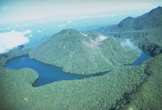
Geological Summary. Loloru, the SE-most volcano on Bougainville Island, is the source of a broad ignimbrite apron that covers much of the southern part of the island. The summit consists of two nested calderas, and a forested andesitic lava dome that restricts a crescent-shaped lake to the eastern side of the younger caldera. The smooth flanks of the pyroclastic shield are dissected by radiating deep valleys. A pristine lava flow occurs on the SE flank. Loloru is constructed within the 10 x 15 km Pleistocene Laluai caldera. The topographically higher Taroka group of volcanoes to the NW and the Takuan group to the north also were constructed within the caldera and deflected the bulk of Loloru ignimbrites to the south. The most recent of several major Holocene explosive eruptions took place about 3,000 years ago.
Information Contacts: D. Lolok, C. McKee, and B. Talai, RVO.