Report on Bandaisan (Japan) — November 1988
Scientific Event Alert Network Bulletin, vol. 13, no. 11 (November 1988)
Managing Editor: Lindsay McClelland.
Bandaisan (Japan) Increased seismicity
Please cite this report as:
Global Volcanism Program, 1988. Report on Bandaisan (Japan) (McClelland, L., ed.). Scientific Event Alert Network Bulletin, 13:11. Smithsonian Institution. https://doi.org/10.5479/si.GVP.SEAN198811-283160
Bandaisan
Japan
37.601°N, 140.072°E; summit elev. 1816 m
All times are local (unless otherwise noted)
Seismicity increased toward the end of November. A total of 188 events were recorded by the seismometer 1.8 km NNW of the summit, up sharply from the background level of ~20/month (figure 1).
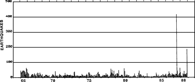 |
Figure 1. Monthly number of recorded earthquakes at Bandai, 1965-88. Courtesy of JMA. |
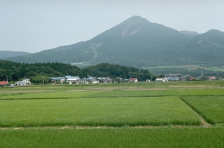
Geological Summary. One of Japan's most noted volcanoes, Bandaisan rises above the north shore of Lake Inawashiro. This complex is formed of several overlapping andesitic stratovolcanoes, the largest of which is Obandai. Kobandaisan peak, which collapsed in 1888, was formed about 50,000 years ago. Obandai was constructed about 40,000 years ago after a Plinian eruption resulted in the collapse of an older edifice and the Okinajima debris avalanche to the SW. The last magmatic eruption took place more than 25,000 years ago, but four major phreatic eruptions have occurred during the past 5,000 years, most recently in 806 and 1888 CE. Seen from the south, Bandaisan presents a conical profile, but much of the north side of the volcano is missing as a result of the collapse of Kobandaisan during the 1888 eruption, causing a debris avalanche that buried several villages and formed several large lakes.
Information Contacts: JMA; AP; UPI.