Report on Ol Doinyo Lengai (Tanzania) — January 1989

Scientific Event Alert Network Bulletin, vol. 14, no. 1 (January 1989)
Managing Editor: Lindsay McClelland.
Ol Doinyo Lengai (Tanzania) Aerial inspection reveals small new flows
Please cite this report as:
Global Volcanism Program, 1989. Report on Ol Doinyo Lengai (Tanzania) (McClelland, L., ed.). Scientific Event Alert Network Bulletin, 14:1. Smithsonian Institution. https://doi.org/10.5479/si.GVP.SEAN198901-222120
Ol Doinyo Lengai
Tanzania
2.764°S, 35.914°E; summit elev. 2962 m
All times are local (unless otherwise noted)
During . . . 22-25 November 1988 . . . the N crater [was] mapped by pacing and prismatic compass (figure 12). An aerial inspection from 0730-0800 on 14 December 1988 revealed small fresh flows (1-2 days old) . . . from the W side of T5/T9 . . . . [Vent T11] appeared cold and hard. The inner nested cone that was forming [on] 25 November had not grown significantly. No new lava had entered the S crater. Fumarolic activity continued around the crater rim, saddle, and crater walls.
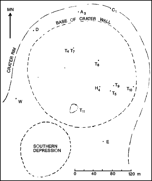 |
Figure 12. Map of Ol Doinyo Lengai, 24 November 1988. Measurements were taken to the highest points on each feature, except for T4/T7, where the measurement was to the westernmost pinnacle. W-E was used as the baseline along the saddle between the N and S craters. Courtesy of C. Nyamweru |
Geological Summary. The symmetrical Ol Doinyo Lengai is the only volcano known to have erupted carbonatite tephras and lavas in historical time. The prominent stratovolcano, known to the Maasai as "The Mountain of God," rises abruptly above the broad plain south of Lake Natron in the Gregory Rift Valley. The cone-building stage ended about 15,000 years ago and was followed by periodic ejection of natrocarbonatitic and nephelinite tephra during the Holocene. Historical eruptions have consisted of smaller tephra ejections and emission of numerous natrocarbonatitic lava flows on the floor of the summit crater and occasionally down the upper flanks. The depth and morphology of the northern crater have changed dramatically during the course of historical eruptions, ranging from steep crater walls about 200 m deep in the mid-20th century to shallow platforms mostly filling the crater. Long-term lava effusion in the summit crater beginning in 1983 had by the turn of the century mostly filled the northern crater; by late 1998 lava had begun overflowing the crater rim.
Information Contacts: C. Nyamweru, Kenyatta Univ.