Report on Kilauea (United States) — March 1989

Scientific Event Alert Network Bulletin, vol. 14, no. 3 (March 1989)
Managing Editor: Lindsay McClelland.
Kilauea (United States) Breakouts upslope slow lava bench growth at coast
Please cite this report as:
Global Volcanism Program, 1989. Report on Kilauea (United States) (McClelland, L., ed.). Scientific Event Alert Network Bulletin, 14:3. Smithsonian Institution. https://doi.org/10.5479/si.GVP.SEAN198903-332010
Kilauea
United States
19.421°N, 155.287°W; summit elev. 1222 m
All times are local (unless otherwise noted)
The level of the lava pond in Kupaianaha vent . . . varied from 21 to 25 m below the rim during March (figure 57). Lava breakouts from the tube system were relatively frequent near the major fault scarp at ~270-360 m elevation. Lava that emerged from the W tube system advanced to 150 m elevation, flowed ~120 m into forest, and passed near the Royal Gardens subdivision, causing no damage. Sporadic breakouts from the E tube produced sluggish pahoehoe flows. Lava advanced to the point where a December 1986 flow had . . . entered the Kalapana Gardens subdivision. Breakouts from the central tube had advanced down the E side of the flow field to 45 m elevation by the end of the month, but remained on top of older flows.
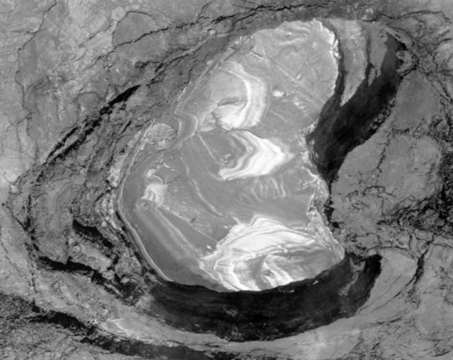 |
Figure 57. The lava pond at Kupaianaha vent on Kīlauea's East rift zone. In this photograph by J. Griggs (USGS), the lava is mostly covered with crust and is about 15 m below the rim of the pond. The pond is ~100 m across at its widest point. The entrance to the main lava tube (below the surface) is located in the upper left (SE) wall of the pond. |
Lava continued to enter the ocean, building a lava bench (figures 58 and 59), although at a diminished rate during strong surface activity. The active portion of the bench was 200 x 80 m in March, and older inactive portions remained susceptible to collapse. Minor collapses occurred 3 and 17 March, then a major collapse on the 23rd at 0335 destroyed 65% of the bench, including almost all of the active section. By the end of the month, the bench was rebuilding and the new active portion measured ~170 x 20 m. Explosivity during the collapses was minor.
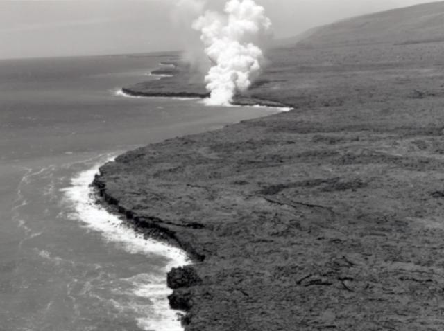 |
Figure 58. View by J. Griggs (USGS) from the E side of Kīlauea's 1986-89 flow field, looking W. The steam plume marks the point where lava has been continuously entering the ocean since May 1988. |
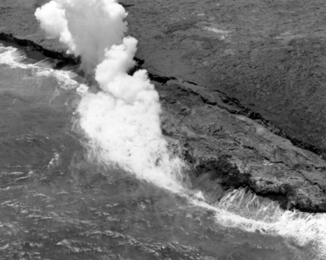 |
Figure 59. Close-up aerial view by J. Griggs (USGS) of Kīlauea's actively growing lava bench, 1-3 m below the older sea cliff. As the bench grows, it spreads laterally (parallel to the sea cliff) as well as seaward. In the photograph, the bench is 30-40 m wide. A smooth tephra deposit, extending onshore from the edge of the sea cliff, is visible to the right of the plume. |
Low-level tremor continued near vents on the middle East rift zone and where lava entered the ocean. Bench collapse was registered as a series of rockfall and acoustic signals at the Wahaula seismic station, 3 km away. Intermediate-depth, long-period events and tremor were intermittent beneath the summit. Bursts of deep tremor were centered 40-60 km beneath the S part of Hawaii.
Geological Summary. Kilauea overlaps the E flank of the massive Mauna Loa shield volcano in the island of Hawaii. Eruptions are prominent in Polynesian legends; written documentation since 1820 records frequent summit and flank lava flow eruptions interspersed with periods of long-term lava lake activity at Halemaumau crater in the summit caldera until 1924. The 3 x 5 km caldera was formed in several stages about 1,500 years ago and during the 18th century; eruptions have also originated from the lengthy East and Southwest rift zones, which extend to the ocean in both directions. About 90% of the surface of the basaltic shield volcano is formed of lava flows less than about 1,100 years old; 70% of the surface is younger than 600 years. The long-term eruption from the East rift zone between 1983 and 2018 produced lava flows covering more than 100 km2, destroyed hundreds of houses, and added new coastline.
Information Contacts: C. Heliker and R. Koyanagi, HVO.