Report on Kilauea (United States) — April 1989

Scientific Event Alert Network Bulletin, vol. 14, no. 4 (April 1989)
Managing Editor: Lindsay McClelland.
Kilauea (United States) Lava flows threaten houses
Please cite this report as:
Global Volcanism Program, 1989. Report on Kilauea (United States) (McClelland, L., ed.). Scientific Event Alert Network Bulletin, 14:4. Smithsonian Institution. https://doi.org/10.5479/si.GVP.SEAN198904-332010
Kilauea
United States
19.421°N, 155.287°W; summit elev. 1222 m
All times are local (unless otherwise noted)
Kīlauea's . . . eruption continued to feed lava through tubes into the ocean near Kupapau Point during April. Surface lava breakouts along the W tube were active 1-12 April and extended from ~300 m (top of the fault scarp) to 70 m altitude. Lava traveled along the W side of the flow field, entering the E margin of the Royal Gardens subdivision (figure 60). A major breakout on the 13th at ~500 m elevation remained active throughout the month. Large surface flows burned forest to the W and on 25 April passed within 50 m of an occupied home . . . . Access to the upper subdivision, as well as several houses, were threatened. By the end of the month, the flow had reached 60 m elevation and slowed, but was still active. Surface activity from the E tube at the top of the fault scarp was sporadic in early April but ceased after the 10th. The terminus of a breakout from the central tube was active just above the Kapaahu kipuka but stagnated after the 12th. The lava breakouts from the W tube on the 13th apparently lowered the magma supply to the E and central tubes, causing their flows to stagnate. The active portion of the seacoast bench that had formed since the 23 March collapse measured 160 x 60 m at the beginning of the month. Following two large collapses on 13 April (at 2024) and 22 April (at 2307), the bench continued to rebuild.
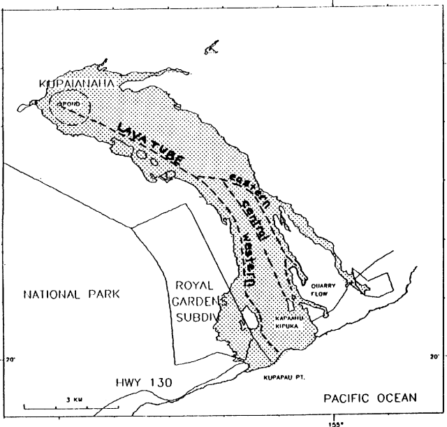 |
Figure 60. Sketch map showing lava flows produced from Kupaianaha, July 1986-April 1989, and the current lava tube system. The April surface flows were mostly confined to the 1986-89 flow field. Courtesy of HVO. |
The lava pond at Kupaianaha was 20-25 m below the rim during April. Lava was observed in the crater bottom of Pu`u `O`o . . . for most of the month, ranging from spatter to a sizeable lava pond that covered much of the crater floor. Gas pistoning events were witnessed at mid-month. By the 25th, only glowing holes in the rubble at the crater bottom could be seen.
Most of April's 18 strongly recorded seismic events . . . were tightly clustered beneath Kīlauea's summit and S flank. Shallow events (0-5 km depth) continued to be recorded. The number of intermediate-depth long-period events beneath the summit decreased and developed a fluctuating pattern after a persistent high rate in March. Increasingly longer bursts of deep tremor (40-60 km depth), at near-regular time intervals during the first half of the month decreased thereafter. Low-level tremor continued beneath Pu`u `O`o and Kupaianaha. Relatively steady tremor amplitude beneath Pu`u `O`o was interrupted 13-17 April by short gas piston bursts and long intervals of banded tremor, correlated with increased activity in the crater. Tremor returned to a relatively steady state in the latter part of the month. Low-amplitude signals from lava entering the sea near Kupapau Point continued to be recorded.
Geological Summary. Kilauea overlaps the E flank of the massive Mauna Loa shield volcano in the island of Hawaii. Eruptions are prominent in Polynesian legends; written documentation since 1820 records frequent summit and flank lava flow eruptions interspersed with periods of long-term lava lake activity at Halemaumau crater in the summit caldera until 1924. The 3 x 5 km caldera was formed in several stages about 1,500 years ago and during the 18th century; eruptions have also originated from the lengthy East and Southwest rift zones, which extend to the ocean in both directions. About 90% of the surface of the basaltic shield volcano is formed of lava flows less than about 1,100 years old; 70% of the surface is younger than 600 years. The long-term eruption from the East rift zone between 1983 and 2018 produced lava flows covering more than 100 km2, destroyed hundreds of houses, and added new coastline.
Information Contacts: C. Heliker and R. Koyanagi, HVO.